Property Record
97 N Hatfield Rd, Hatfield, MA 01038
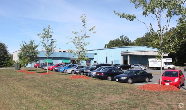
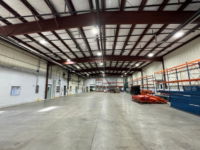
This Property Is For Sale
Current Lease Availabilities
Property Detail
97 N Hatfield Rd
HATF-000211-000025
Hampshire
Commercialbuilding
Massachusetts
I
2 AC
2025
Hampshire County
2025
Hartford
821500
Amherst Town-Northampton, MA
29,335 SF
NEARBY LISTINGS FOR SALE OR LEASE
DEMOGRAPHICS near 97 N Hatfield Rd
1 mile
3 mile
5 mile
2025 Total Population
529
5,117
44,663
2030 Population
522
5,047
44,695
Pop Growth 2025-2030
(1.32%)
(1.37%)
+ 0.07%
Average Age
46
47
35
2025 Total Households
239
2,299
12,561
HH Growth 2025-2030
(1.26%)
(1.30%)
(0.14%)
Median Household Inc
$80,357
$102,853
$80,528
Avg Household Size
2.20
2.20
2.20
2025 Avg HH Vehicles
2.00
2.00
2.00
Median Home Value
$419,178
$456,439
$447,616
Median Year Built
1960
1962
1967
Nearby Places
Map Layers
Map Styles
 Street
 Aerial
Layers
 Traffic
 Biking
Places
Listings with unknown addresses are not visible on the map
- Restaurants
- Banks
- Shops
- Fitness
- Groceries
PUBLIC TRANSPORTATION
AIRPORT
Bradley International
Drive
Walk
Distance
Bradley International
63 min
37.7 mi
Nearby Properties
Address
Land Use
TOTAL SIZE
Lot Size
Zoning
Address
Land Use
TOTAL SIZE
Lot Size
Zoning
476,724 SF
57.56 AC
I
Address
Land Use
TOTAL SIZE
Lot Size
Zoning
359,938 SF
38.84 AC
I
Address
Land Use
TOTAL SIZE
Lot Size
Zoning
59,471 SF
35 AC
LGT
Address
Land Use
TOTAL SIZE
Lot Size
Zoning
53,344 SF
9.07 AC
TC
Address
Land Use
TOTAL SIZE
Lot Size
Zoning
280,518 SF
60.66 AC
I
Address
Land Use
TOTAL SIZE
Lot Size
Zoning
55,644 SF
5.21 AC
BUS
Address
Land Use
TOTAL SIZE
Lot Size
Zoning
33,525 SF
5.36 AC
I
Address
Land Use
TOTAL SIZE
Lot Size
Zoning
4,897 SF
7.63 AC
I
Address
Land Use
TOTAL SIZE
Lot Size
Zoning
99,595 SF
47 AC
R4
Address
Land Use
TOTAL SIZE
Lot Size
Zoning
22,936 SF
5.13 AC
B
Address
Land Use
TOTAL SIZE
Lot Size
Zoning
29,575 SF
3.52 AC
LGT
Address
Land Use
TOTAL SIZE
Lot Size
Zoning
58,439 SF
2.97 AC
LGT
Address
Land Use
TOTAL SIZE
Lot Size
Zoning
56,924 SF
7.50 AC
I
Address
Land Use
TOTAL SIZE
Lot Size
Zoning
42,789 SF
4.16 AC
I
Address
Land Use
TOTAL SIZE
Lot Size
Zoning
70,318 SF
10.46 AC
I
Address
Land Use
TOTAL SIZE
Lot Size
Zoning
24,976 SF
3.82 AC
LI
Address
Land Use
TOTAL SIZE
Lot Size
Zoning
26,079 SF
1.62 AC
TC
Address
Land Use
TOTAL SIZE
Lot Size
Zoning
5,346 SF
9.50 AC
LB
Address
Land Use
TOTAL SIZE
Lot Size
Zoning
23,460 SF
8.61 AC
B
Address
Land Use
TOTAL SIZE
Lot Size
Zoning
1,775 SF
1.61 AC
HB
Address
Land Use
TOTAL SIZE
Lot Size
Zoning
24,360 SF
2.75 AC
LGT
Address
Land Use
TOTAL SIZE
Lot Size
Zoning
72,027 SF
16 AC
TC
Address
Land Use
TOTAL SIZE
Lot Size
Zoning
11,141 SF
15.67 AC
LGT
Address
Land Use
TOTAL SIZE
Lot Size
Zoning
896 SF
18.84 AC
LGT
Address
Land Use
TOTAL SIZE
Lot Size
Zoning
5.49 AC
C
Address
Land Use
TOTAL SIZE
Lot Size
Zoning
26,772 SF
4.87 AC
B
Address
Land Use
TOTAL SIZE
Lot Size
Zoning
3.22 AC
C
Address
Land Use
TOTAL SIZE
Lot Size
Zoning
33,025 SF
5.53 AC
B
Address
Land Use
TOTAL SIZE
Lot Size
Zoning
15,289 SF
4.87 AC
B
The World's #1 Commercial Real Estate Marketplace
Connect with us
© 2026 CoStar Group
The information above has been obtained from sources believed reliable. While we do not doubt its accuracy we have not verified it and make no guarantee, warranty or representation about it. It is your responsibility to independently confirm its accuracy and completeness. Any projections, opinions, assumptions, or estimates used are for example only and do not represent the current or future performance of the property. The value of this transaction to you depends on tax and other factors which should be evaluated by your tax, financial, and legal advisors. You and your advisors should conduct a careful, independent investigation of the property to determine to your satisfaction the suitability of the property for your needs.