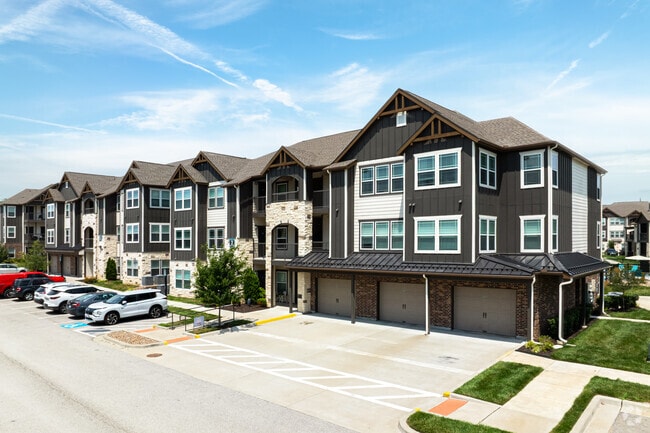
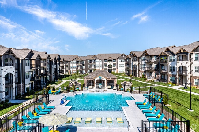
Property Record
97 Ne 97Th St, Kansas City, MO 64155

NEARBY LISTINGS FOR SALE OR LEASE
Property Detail
97 Ne 97Th St
Kansas City, MO-KS
At North
09-917-00-01-013-00
97 AT NORTH OAK LT 1
Residentialacreage
Clay
X
Missouri
29095C0064G
1
2024
20.34 AC
2025
Meadowbrook Heights
021313
Kansas City
DEMOGRAPHICS near 97 Ne 97Th St
1 Mile
3 Mile
5 Mile
2024 Total Population
10,814
50,660
118,307
2029 Population
11,260
53,520
126,016
Pop Growth 2024-2029
+ 4.12%
+ 5.65%
+ 6.52%
Average Age
38
38
39
2024 Total Households
4,267
20,085
48,243
HH Growth 2024-2029
+ 4.15%
+ 5.72%
+ 6.61%
Median Household Inc
$73,539
$84,123
$78,242
Avg Household Size
2.50
2.50
2.40
2024 Avg HH Vehicles
2.00
2.00
2.00
Median Home Value
$243,233
$252,860
$254,535
Median Year Built
1994
1995
1992
Nearby Places
Map Layers
Map Styles
 Street
 Aerial
- Restaurants
- Banks
- Shops
- Fitness
- Groceries
PUBLIC TRANSPORTATION
AIRPORT
Kansas City International
DRIVE
WALK
Distance
Kansas City International
17 min
11.6 mi
Freight Ports
Tulsa Port Of Catoosa
DRIVE
WALK
Distance
Tulsa Port Of Catoosa
283 min
251.5 mi
Nearby Properties
Address
Land Use
TOTAL SIZE
Lot Size
Zoning
Address
Land Use
TOTAL SIZE
Lot Size
Zoning
220.49 AC
Address
Land Use
TOTAL SIZE
Lot Size
Zoning
Address
Land Use
TOTAL SIZE
Lot Size
Zoning
195.27 AC
Address
Land Use
TOTAL SIZE
Lot Size
Zoning
56.76 AC
Address
Land Use
TOTAL SIZE
Lot Size
Zoning
68.42 AC
Address
Land Use
TOTAL SIZE
Lot Size
Zoning
Address
Land Use
TOTAL SIZE
Lot Size
Zoning
50.67 AC
Address
Land Use
TOTAL SIZE
Lot Size
Zoning
417,393 SF
22.13 AC
Address
Land Use
TOTAL SIZE
Lot Size
Zoning
Address
Land Use
TOTAL SIZE
Lot Size
Zoning
349,586 SF
29.58 AC
Address
Land Use
TOTAL SIZE
Lot Size
Zoning
42.55 AC
Address
Land Use
TOTAL SIZE
Lot Size
Zoning
16.71 AC
Address
Land Use
TOTAL SIZE
Lot Size
Zoning
14.01 AC
Address
Land Use
TOTAL SIZE
Lot Size
Zoning
13.25 AC
Address
Land Use
TOTAL SIZE
Lot Size
Zoning
20.09 AC
Address
Land Use
TOTAL SIZE
Lot Size
Zoning
4.84 AC
Address
Land Use
TOTAL SIZE
Lot Size
Zoning
Address
Land Use
TOTAL SIZE
Lot Size
Zoning
491,028 SF
16.35 AC
Address
Land Use
TOTAL SIZE
Lot Size
Zoning
5.69 AC
Address
Land Use
TOTAL SIZE
Lot Size
Zoning
255,096 SF
24.86 AC
Address
Land Use
TOTAL SIZE
Lot Size
Zoning
Address
Land Use
TOTAL SIZE
Lot Size
Zoning
13.01 AC
Address
Land Use
TOTAL SIZE
Lot Size
Zoning
Address
Land Use
TOTAL SIZE
Lot Size
Zoning
10.82 AC
Address
Land Use
TOTAL SIZE
Lot Size
Zoning
0.86 AC
Address
Land Use
TOTAL SIZE
Lot Size
Zoning
11.98 AC
Address
Land Use
TOTAL SIZE
Lot Size
Zoning
2.43 AC
Address
Land Use
TOTAL SIZE
Lot Size
Zoning
2,678 SF
12.77 AC
Address
Land Use
TOTAL SIZE
Lot Size
Zoning
10.29 AC
The World's #1 Commercial Real Estate Marketplace
Connect with us
© 2026 CoStar Group
The information above has been obtained from sources believed reliable. While we do not doubt its accuracy we have not verified it and make no guarantee, warranty or representation about it. It is your responsibility to independently confirm its accuracy and completeness. Any projections, opinions, assumptions, or estimates used are for example only and do not represent the current or future performance of the property. The value of this transaction to you depends on tax and other factors which should be evaluated by your tax, financial, and legal advisors. You and your advisors should conduct a careful, independent investigation of the property to determine to your satisfaction the suitability of the property for your needs.