Property Record
97 Patchchogue-Yaphank Rd, Yaphank, NY 11980

Save to a Folder
{{folder.Name}}
{{folder.ListingIds.length}} Properties
{{folder.ListingIds.length}} Property
Create a New Folder
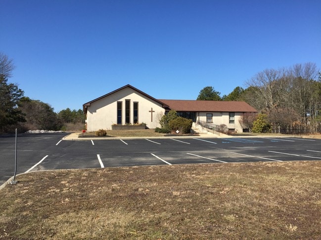
Property Detail
97 Patchchogue-Yaphank Rd
Nassau County-Suffolk County, NY
N LEEDS T124 200 E PATCH YP X1254
0200-739-00-01-00-001-004
SUFFOLK
Religious
New York
B and X Area of moderate flood hazard, usually the area between the limits of the 100-year and 500-year floods.
100
2024
5.42 AC
2025
Central Suffolk
158707
Long Island (New York)
NEARBY LISTINGS FOR SALE OR LEASE
DEMOGRAPHICS near 97 Patchchogue-Yaphank Rd
1 mile
3 mile
5 mile
2025 Total Population
933
41,039
139,436
2030 Population
930
40,895
139,243
Pop Growth 2025-2030
(0.32%)
(0.35%)
(0.14%)
Average Age
41
40
41
2025 Total Households
312
13,227
47,894
HH Growth 2025-2030
(0.32%)
(0.67%)
(0.38%)
Median Household Inc
$121,484
$108,743
$108,864
Avg Household Size
2.90
2.90
2.80
2025 Avg HH Vehicles
2.00
2.00
2.00
Median Home Value
$506,579
$466,773
$464,150
Median Year Built
1984
1977
1976
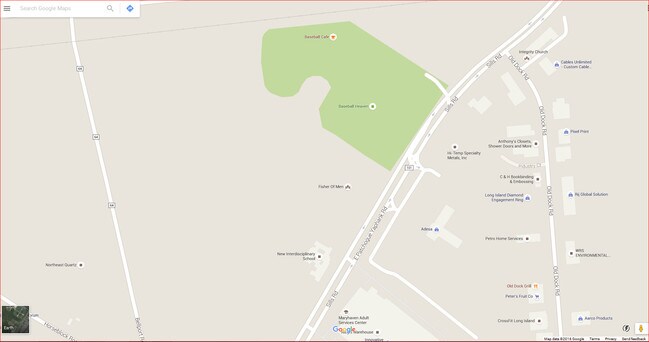
Nearby Places
Map Layers
Map Styles
 Street
 Aerial
Layers
 Traffic
 Biking
Places
Listings with unknown addresses are not visible on the map
- Restaurants
- Banks
- Shops
- Fitness
- Groceries
PUBLIC TRANSPORTATION
COMMUTER RAIL
Yaphank Station (Greenport Branch - Long Island Rail Road)
Drive
Walk
Distance
Yaphank Station (Greenport Branch - Long Island Rail Road)
5 min
2.8 mi
Medford Station (Greenport Branch - Long Island Rail Road)
Drive
Walk
Distance
Medford Station (Greenport Branch - Long Island Rail Road)
6 min
3.6 mi
AIRPORT
Long Island MacArthur
Drive
Walk
Distance
Long Island MacArthur
18 min
10.6 mi
Freight Ports
Port of New Haven
Drive
Walk
Distance
Port of New Haven
131 min
49.8 mi
SALE & LEASE HISTORY
LISTING DATE
SALE/LEASE

Apr 13, 2017
For Sale
Nearby Properties
Address
Land Use
TOTAL SIZE
Lot Size
Zoning
Address
Land Use
TOTAL SIZE
Lot Size
Zoning
19.30 AC
Address
Land Use
TOTAL SIZE
Lot Size
Zoning
60,680 SF
2.30 AC
LI40
Address
Land Use
TOTAL SIZE
Lot Size
Zoning
4,925 SF
0.27 AC
VILLA
Address
Land Use
TOTAL SIZE
Lot Size
Zoning
3,238 SF
0.15 AC
VILLA
Address
Land Use
TOTAL SIZE
Lot Size
Zoning
1,362 SF
0.41 AC
HC
Address
Land Use
TOTAL SIZE
Lot Size
Zoning
0.80 AC
CR80
Address
Land Use
TOTAL SIZE
Lot Size
Zoning
19.01 AC
Address
Land Use
TOTAL SIZE
Lot Size
Zoning
0.98 AC
CR80
Address
Land Use
TOTAL SIZE
Lot Size
Zoning
Address
Land Use
TOTAL SIZE
Lot Size
Zoning
71.41 AC
Address
Land Use
TOTAL SIZE
Lot Size
Zoning
12.47 AC
Address
Land Use
TOTAL SIZE
Lot Size
Zoning
0.53 AC
R20
Address
Land Use
TOTAL SIZE
Lot Size
Zoning
32.70 AC
Address
Land Use
TOTAL SIZE
Lot Size
Zoning
165.20 AC
Address
Land Use
TOTAL SIZE
Lot Size
Zoning
14.10 AC
Address
Land Use
TOTAL SIZE
Lot Size
Zoning
63.90 AC
Address
Land Use
TOTAL SIZE
Lot Size
Zoning
16.04 AC
Address
Land Use
TOTAL SIZE
Lot Size
Zoning
73.70 AC
Address
Land Use
TOTAL SIZE
Lot Size
Zoning
37.29 AC
Address
Land Use
TOTAL SIZE
Lot Size
Zoning
14.02 AC
Address
Land Use
TOTAL SIZE
Lot Size
Zoning
Address
Land Use
TOTAL SIZE
Lot Size
Zoning
Address
Land Use
TOTAL SIZE
Lot Size
Zoning
49.68 AC
Address
Land Use
TOTAL SIZE
Lot Size
Zoning
Address
Land Use
TOTAL SIZE
Lot Size
Zoning
37.80 AC
Address
Land Use
TOTAL SIZE
Lot Size
Zoning
28.10 AC
Address
Land Use
TOTAL SIZE
Lot Size
Zoning
27.87 AC
Address
Land Use
TOTAL SIZE
Lot Size
Zoning
3.33 AC
Address
Land Use
TOTAL SIZE
Lot Size
Zoning
28.59 AC
Address
Land Use
TOTAL SIZE
Lot Size
Zoning
32.24 AC
The World's #1 Commercial Real Estate Marketplace
Connect with us
© 2026 CoStar Group
The information above has been obtained from sources believed reliable. While we do not doubt its accuracy we have not verified it and make no guarantee, warranty or representation about it. It is your responsibility to independently confirm its accuracy and completeness. Any projections, opinions, assumptions, or estimates used are for example only and do not represent the current or future performance of the property. The value of this transaction to you depends on tax and other factors which should be evaluated by your tax, financial, and legal advisors. You and your advisors should conduct a careful, independent investigation of the property to determine to your satisfaction the suitability of the property for your needs.