Property Record
97R Preston Rd, Jewett City, CT 06351


NEARBY LISTINGS FOR SALE OR LEASE
-
-
View all Jewett City listings for sale on LoopNet.com
Property Detail
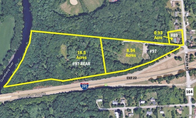
97R Preston Rd
GRIS-000044-000087-000049
New London
Commercialacreage
Connecticut
X
49
09011C0228H
18.60 AC
2024
NE New London/Norwich
2025
Hartford
709200
Norwich-New London, CT
DEMOGRAPHICS near 97R Preston Rd
1 Mile
3 Mile
5 Mile
2024 Total Population
2,380
10,916
25,319
2029 Population
2,457
10,988
25,336
Pop Growth 2024-2029
+ 3.24%
+ 0.66%
+ 0.07%
Average Age
40
42
42
2024 Total Households
1,011
4,411
10,434
HH Growth 2024-2029
+ 3.36%
+ 0.73%
+ 0.09%
Median Household Inc
$53,873
$67,500
$66,847
Avg Household Size
2.30
2.50
2.40
2024 Avg HH Vehicles
2.00
2.00
2.00
Median Home Value
$186,627
$257,220
$247,778
Median Year Built
1970
1973
1972
Nearby Places
Map Layers
Map Styles
 Street
 Aerial
- Restaurants
- Banks
- Shops
- Fitness
- Groceries
SALE & LEASE HISTORY
LISTING DATE
SALE/LEASE

Sep 24, 2016
For Sale
Aug 09, 2017
For Sale
Nearby Properties
Address
Land Use
TOTAL SIZE
Lot Size
Zoning
Address
Land Use
TOTAL SIZE
Lot Size
Zoning
160,789 SF
14 AC
R20
Address
Land Use
TOTAL SIZE
Lot Size
Zoning
21.33 AC
C4
Address
Land Use
TOTAL SIZE
Lot Size
Zoning
3 AC
BR
Address
Land Use
TOTAL SIZE
Lot Size
Zoning
182,533 SF
21.53 AC
C4
Address
Land Use
TOTAL SIZE
Lot Size
Zoning
138,994 SF
35.90 AC
BR
Address
Land Use
TOTAL SIZE
Lot Size
Zoning
23.61 AC
R60
Address
Land Use
TOTAL SIZE
Lot Size
Zoning
137,895 SF
11.28 AC
C4
Address
Land Use
TOTAL SIZE
Lot Size
Zoning
115,363 SF
16.51 AC
C4
Address
Land Use
TOTAL SIZE
Lot Size
Zoning
132,690 SF
63.74 AC
R-20
Address
Land Use
TOTAL SIZE
Lot Size
Zoning
138,642 SF
9.94 AC
C4
Address
Land Use
TOTAL SIZE
Lot Size
Zoning
77,971 SF
1.67 AC
C2
Address
Land Use
TOTAL SIZE
Lot Size
Zoning
34,004 SF
16.32 AC
C4
Address
Land Use
TOTAL SIZE
Lot Size
Zoning
5.64 AC
C1
Address
Land Use
TOTAL SIZE
Lot Size
Zoning
14,082 SF
1.66 AC
R60
Address
Land Use
TOTAL SIZE
Lot Size
Zoning
73,564 SF
8.29 AC
C-I
Address
Land Use
TOTAL SIZE
Lot Size
Zoning
21,084 SF
1.70 AC
B-C
Address
Land Use
TOTAL SIZE
Lot Size
Zoning
44,820 SF
4.47 AC
C1
Address
Land Use
TOTAL SIZE
Lot Size
Zoning
26,335 SF
200.90 AC
C3
Address
Land Use
TOTAL SIZE
Lot Size
Zoning
5,027 SF
83 AC
C1
Address
Land Use
TOTAL SIZE
Lot Size
Zoning
17,074 SF
2.67 AC
C4
Address
Land Use
TOTAL SIZE
Lot Size
Zoning
18,503 SF
1.83 AC
C4
Address
Land Use
TOTAL SIZE
Lot Size
Zoning
15,788 SF
0.43 AC
B-C
Address
Land Use
TOTAL SIZE
Lot Size
Zoning
16,418 SF
7.30 AC
200
Address
Land Use
TOTAL SIZE
Lot Size
Zoning
1.99 AC
B-R
Address
Land Use
TOTAL SIZE
Lot Size
Zoning
5,508 SF
59.80 AC
C2
Address
Land Use
TOTAL SIZE
Lot Size
Zoning
50 AC
C1
Address
Land Use
TOTAL SIZE
Lot Size
Zoning
25,276 SF
2.61 AC
BR
Address
Land Use
TOTAL SIZE
Lot Size
Zoning
10,382 SF
6.33 AC
C4
Address
Land Use
TOTAL SIZE
Lot Size
Zoning
6.53 AC
BRM
Address
Land Use
TOTAL SIZE
Lot Size
Zoning
6,240 SF
2 AC
BRC
The World's #1 Commercial Real Estate Marketplace
Connect with us
© 2025 CoStar Group
The information above has been obtained from sources believed reliable. While we do not doubt its accuracy we have not verified it and make no guarantee, warranty or representation about it. It is your responsibility to independently confirm its accuracy and completeness. Any projections, opinions, assumptions, or estimates used are for example only and do not represent the current or future performance of the property. The value of this transaction to you depends on tax and other factors which should be evaluated by your tax, financial, and legal advisors. You and your advisors should conduct a careful, independent investigation of the property to determine to your satisfaction the suitability of the property for your needs.