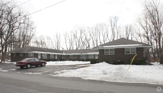
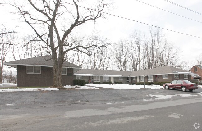
Property Record
97 Sherman St, Schenectady, NY 12303

Property Detail
97 Sherman St
059-016-0002-008-000-0000
PT107 APTS,BK,8U HIGHBRDGE MNR 4 5.-399-3
Apartment
Schenectady
R-1, B-1
New York
B and X Area of moderate flood hazard, usually the area between the limits of the 100-year and 500-year floods.
8.000
2025
0.28 AC
2024
Outer Schenectady County
032901
Albany/Schenectady/Troy
5,760 SF
Albany-Schenectady-Troy, NY
NEARBY LISTINGS FOR SALE OR LEASE
-
-
View all Schenectady listings for sale on LoopNet.com
DEMOGRAPHICS near 97 Sherman St
1 mile
3 mile
5 mile
2024 Total Population
8,602
90,293
160,265
2029 Population
8,684
91,326
162,878
Pop Growth 2024-2029
+ 0.95%
+ 1.14%
+ 1.63%
Average Age
44
40
40
2024 Total Households
3,872
36,033
65,112
HH Growth 2024-2029
+ 0.88%
+ 1.24%
+ 1.77%
Median Household Inc
$73,486
$68,511
$76,427
Avg Household Size
2.10
2.30
2.30
2024 Avg HH Vehicles
2.00
2.00
2.00
Median Home Value
$206,616
$218,671
$253,685
Median Year Built
1958
1951
1956
Nearby Places
Map Layers
Map Styles
 Street
 Aerial
Transit
 Traffic
 Biking
Places
Listings with unknown addresses are not visible on the map
- Restaurants
- Banks
- Shops
- Fitness
- Groceries
PUBLIC TRANSPORTATION
AIRPORT
Albany International
Drive
Walk
Distance
Albany International
18 min
9.4 mi
Nearby Properties
Address
Land Use
TOTAL SIZE
Lot Size
Zoning
Address
Land Use
TOTAL SIZE
Lot Size
Zoning
11,700 SF
43.80 AC
R2
Address
Land Use
TOTAL SIZE
Lot Size
Zoning
184,878 SF
15.58 AC
03 - MULTI
Address
Land Use
TOTAL SIZE
Lot Size
Zoning
102,862 SF
32.45 AC
CS
Address
Land Use
TOTAL SIZE
Lot Size
Zoning
120,755 SF
33.88 AC
R1
Address
Land Use
TOTAL SIZE
Lot Size
Zoning
138,014 SF
4 AC
02 - SINGL
Address
Land Use
TOTAL SIZE
Lot Size
Zoning
382,858 SF
70.33 AC
R-1
Address
Land Use
TOTAL SIZE
Lot Size
Zoning
59,240 SF
0.72 AC
05 - COMME
Address
Land Use
TOTAL SIZE
Lot Size
Zoning
234,485 SF
42.50 AC
02 - SINGL
Address
Land Use
TOTAL SIZE
Lot Size
Zoning
284,171 SF
16.40 AC
03 - MULTI
Address
Land Use
TOTAL SIZE
Lot Size
Zoning
183,759 SF
1.40 AC
05 - COMME
Address
Land Use
TOTAL SIZE
Lot Size
Zoning
181,230 SF
1.02 AC
05 - COMME
Address
Land Use
TOTAL SIZE
Lot Size
Zoning
67,526 SF
9.40 AC
R1
Address
Land Use
TOTAL SIZE
Lot Size
Zoning
4,680 SF
11.39 AC
CH
Address
Land Use
TOTAL SIZE
Lot Size
Zoning
78,326 SF
27.47 AC
R40
Address
Land Use
TOTAL SIZE
Lot Size
Zoning
21,791 SF
4.93 AC
B-1, B-2
Address
Land Use
TOTAL SIZE
Lot Size
Zoning
21,791 SF
4.86 AC
B-1, B-2
Address
Land Use
TOTAL SIZE
Lot Size
Zoning
93,846 SF
3 AC
R2
Address
Land Use
TOTAL SIZE
Lot Size
Zoning
Address
Land Use
TOTAL SIZE
Lot Size
Zoning
86,049 SF
17.10 AC
RO30
Address
Land Use
TOTAL SIZE
Lot Size
Zoning
45,896 SF
10.20 AC
03 - MULTI
Address
Land Use
TOTAL SIZE
Lot Size
Zoning
135,155 SF
6.43 AC
03 - MULTI
Address
Land Use
TOTAL SIZE
Lot Size
Zoning
202,050 SF
20.75 AC
B-2
Address
Land Use
TOTAL SIZE
Lot Size
Zoning
116,392 SF
1.84 AC
05 - COMME
Address
Land Use
TOTAL SIZE
Lot Size
Zoning
79,041 SF
13.20 AC
CN
Address
Land Use
TOTAL SIZE
Lot Size
Zoning
7,216 SF
15.90 AC
03 - MULTI
Address
Land Use
TOTAL SIZE
Lot Size
Zoning
120,373 SF
9.68 AC
CS
Address
Land Use
TOTAL SIZE
Lot Size
Zoning
127,632 SF
3.50 AC
B-1
Address
Land Use
TOTAL SIZE
Lot Size
Zoning
161,606 SF
1.14 AC
05 - COMME
Address
Land Use
TOTAL SIZE
Lot Size
Zoning
97,440 SF
8.15 AC
B-2
Address
Land Use
TOTAL SIZE
Lot Size
Zoning
111,915 SF
15.04 AC
05 - COMME
The World's #1 Commercial Real Estate Marketplace
Connect with us
© 2026 CoStar Group
The information above has been obtained from sources believed reliable. While we do not doubt its accuracy we have not verified it and make no guarantee, warranty or representation about it. It is your responsibility to independently confirm its accuracy and completeness. Any projections, opinions, assumptions, or estimates used are for example only and do not represent the current or future performance of the property. The value of this transaction to you depends on tax and other factors which should be evaluated by your tax, financial, and legal advisors. You and your advisors should conduct a careful, independent investigation of the property to determine to your satisfaction the suitability of the property for your needs.