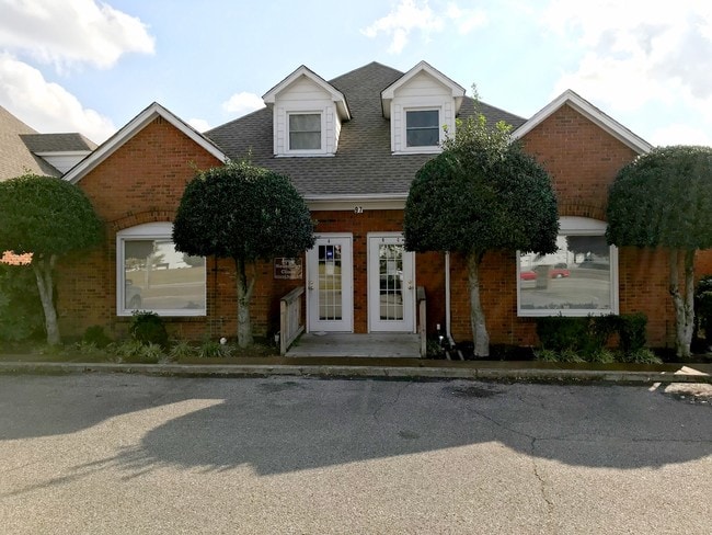
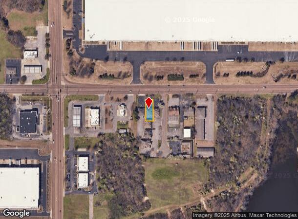
Property Record
97 Stateline Rd W, Southaven, MS 38671

NEARBY LISTINGS FOR SALE OR LEASE
Property Detail
97 Stateline Rd W
Memphis, TN-MS-AR
Greenbrook
1074191000000600
GREENBROOK COMMERCIAL PARK 2ND REVISION LOT 6
Officebuilding
DeSoto
X
Mississippi
47157C0580F
6
2024
0.16 AC
2024
DeSoto County
070522
Memphis
3,245 SF
DEMOGRAPHICS near 97 Stateline Rd W
1 Mile
3 Mile
5 Mile
2024 Total Population
3,381
49,858
131,994
2029 Population
3,575
52,235
138,512
Pop Growth 2024-2029
+ 5.74%
+ 4.77%
+ 4.94%
Average Age
37
38
38
2024 Total Households
1,240
18,950
50,181
HH Growth 2024-2029
+ 5.81%
+ 4.78%
+ 5.00%
Median Household Inc
$42,608
$51,447
$47,296
Avg Household Size
2.70
2.60
2.60
2024 Avg HH Vehicles
2.00
2.00
2.00
Median Home Value
$122,237
$149,648
$146,274
Median Year Built
1977
1976
1978
Nearby Places
- Restaurants
- Banks
- Shops
- Fitness
- Groceries
PUBLIC TRANSPORTATION
AIRPORT
Memphis International
DRIVE
WALK
Distance
Memphis International
14 min
5.8 mi
SALE & LEASE HISTORY
LISTING DATE
SALE/LEASE

Sep 24, 2016
For Sale
Mar 28, 2018
For Sale
Jan 12, 2017
For Lease
Dec 07, 2017
For Sale
Nearby Properties
Address
Land Use
TOTAL SIZE
Lot Size
Zoning
Address
Land Use
TOTAL SIZE
Lot Size
Zoning
1,013,319 SF
38.86 AC
EMP
Address
Land Use
TOTAL SIZE
Lot Size
Zoning
986,374 SF
68.79 AC
CA
Address
Land Use
TOTAL SIZE
Lot Size
Zoning
717,155 SF
83.34 AC
CA
Address
Land Use
TOTAL SIZE
Lot Size
Zoning
897,076 SF
47.33 AC
CA
Address
Land Use
TOTAL SIZE
Lot Size
Zoning
732,894 SF
79.73 AC
WD
Address
Land Use
TOTAL SIZE
Lot Size
Zoning
586,847 SF
37 AC
CA
Address
Land Use
TOTAL SIZE
Lot Size
Zoning
1,009,363 SF
78.56 AC
EMP
Address
Land Use
TOTAL SIZE
Lot Size
Zoning
328,300 SF
33.78 AC
CA
Address
Land Use
TOTAL SIZE
Lot Size
Zoning
853,440 SF
39.22 AC
EMP
Address
Land Use
TOTAL SIZE
Lot Size
Zoning
321.59 AC
R-8
Address
Land Use
TOTAL SIZE
Lot Size
Zoning
265,600 SF
22.03 AC
CA
Address
Land Use
TOTAL SIZE
Lot Size
Zoning
63,842 SF
11 AC
R-6
Address
Land Use
TOTAL SIZE
Lot Size
Zoning
432,700 SF
28.16 AC
EMP
Address
Land Use
TOTAL SIZE
Lot Size
Zoning
338,368 SF
15.70 AC
R-8
Address
Land Use
TOTAL SIZE
Lot Size
Zoning
344,016 SF
16.50 AC
R-8
Address
Land Use
TOTAL SIZE
Lot Size
Zoning
316,573 SF
30.77 AC
CA
Address
Land Use
TOTAL SIZE
Lot Size
Zoning
188,404 SF
59.17 AC
R-8
Address
Land Use
TOTAL SIZE
Lot Size
Zoning
165,227 SF
25.12 AC
RU-3
Address
Land Use
TOTAL SIZE
Lot Size
Zoning
298,852 SF
18.75 AC
RU-2
Address
Land Use
TOTAL SIZE
Lot Size
Zoning
245,848 SF
12.06 AC
CA
Address
Land Use
TOTAL SIZE
Lot Size
Zoning
61,164 SF
36.95 AC
RU-3
Address
Land Use
TOTAL SIZE
Lot Size
Zoning
811,203 SF
47.71 AC
M-1
Address
Land Use
TOTAL SIZE
Lot Size
Zoning
230,103 SF
22.07 AC
CMU-2
Address
Land Use
TOTAL SIZE
Lot Size
Zoning
48.35 AC
EMP
Address
Land Use
TOTAL SIZE
Lot Size
Zoning
226,438 SF
19.52 AC
C-1
Address
Land Use
TOTAL SIZE
Lot Size
Zoning
39.98 AC
PUD
Address
Land Use
TOTAL SIZE
Lot Size
Zoning
741,634 SF
34.89 AC
PBP
Address
Land Use
TOTAL SIZE
Lot Size
Zoning
779,780 SF
46.22 AC
PBP
Address
Land Use
TOTAL SIZE
Lot Size
Zoning
213,853 SF
15.08 AC
CA
Address
Land Use
TOTAL SIZE
Lot Size
Zoning
201,383 SF
13.20 AC
CA
The World's #1 Commercial Real Estate Marketplace
Connect with us
© 2025 CoStar Group
The information above has been obtained from sources believed reliable. While we do not doubt its accuracy we have not verified it and make no guarantee, warranty or representation about it. It is your responsibility to independently confirm its accuracy and completeness. Any projections, opinions, assumptions, or estimates used are for example only and do not represent the current or future performance of the property. The value of this transaction to you depends on tax and other factors which should be evaluated by your tax, financial, and legal advisors. You and your advisors should conduct a careful, independent investigation of the property to determine to your satisfaction the suitability of the property for your needs.