Property Record
970 Kennedys Lndg, Cincinnati, OH 45245

NEARBY LISTINGS FOR SALE OR LEASE
Property Detail
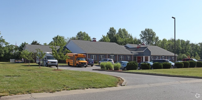
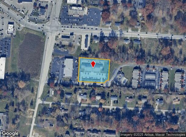
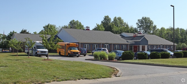
970 Kennedys Lndg
Daycare
Clermont
X
Ohio
21037C0075E
1.61 AC
2024
Eastgate/Anderson Twp
2024
Cincinnati/Dayton
041306
Cincinnati, OH-KY-IN
11,775 SF
41-31-04A-219
DEMOGRAPHICS near 970 Kennedys Lndg
1 Mile
3 Mile
5 Mile
2024 Total Population
8,381
52,571
101,470
2029 Population
8,641
54,095
103,341
Pop Growth 2024-2029
+ 3.10%
+ 2.90%
+ 1.84%
Average Age
41
41
41
2024 Total Households
3,924
22,231
41,058
HH Growth 2024-2029
+ 3.39%
+ 3.04%
+ 2.05%
Median Household Inc
$62,235
$64,497
$71,555
Avg Household Size
2.00
2.30
2.40
2024 Avg HH Vehicles
2.00
2.00
2.00
Median Home Value
$191,584
$210,712
$241,607
Median Year Built
1990
1985
1984
Nearby Places
Map Layers
Map Styles
 Street
 Aerial
- Restaurants
- Banks
- Shops
- Fitness
- Groceries
PUBLIC TRANSPORTATION
AIRPORT
Cincinnati/Northern Kentucky International
DRIVE
WALK
Distance
Cincinnati/Northern Kentucky International
41 min
27.1 mi
Nearby Properties
Address
Land Use
TOTAL SIZE
Lot Size
Zoning
Address
Land Use
TOTAL SIZE
Lot Size
Zoning
7,560 SF
79.10 AC
Address
Land Use
TOTAL SIZE
Lot Size
Zoning
104,856 SF
32.81 AC
Address
Land Use
TOTAL SIZE
Lot Size
Zoning
50,382 SF
33.05 AC
Address
Land Use
TOTAL SIZE
Lot Size
Zoning
154,426 SF
35.05 AC
Address
Land Use
TOTAL SIZE
Lot Size
Zoning
Address
Land Use
TOTAL SIZE
Lot Size
Zoning
52,178 SF
5.98 AC
Address
Land Use
TOTAL SIZE
Lot Size
Zoning
236,920 SF
18.94 AC
Address
Land Use
TOTAL SIZE
Lot Size
Zoning
49.15 AC
Address
Land Use
TOTAL SIZE
Lot Size
Zoning
56,080 SF
4.40 AC
Address
Land Use
TOTAL SIZE
Lot Size
Zoning
72,272 SF
20.31 AC
Address
Land Use
TOTAL SIZE
Lot Size
Zoning
42,078 SF
58.22 AC
Address
Land Use
TOTAL SIZE
Lot Size
Zoning
14.24 AC
Address
Land Use
TOTAL SIZE
Lot Size
Zoning
78,145 SF
19.91 AC
Address
Land Use
TOTAL SIZE
Lot Size
Zoning
26,637 SF
6.97 AC
Address
Land Use
TOTAL SIZE
Lot Size
Zoning
17,700 SF
50.11 AC
Address
Land Use
TOTAL SIZE
Lot Size
Zoning
27.01 AC
Address
Land Use
TOTAL SIZE
Lot Size
Zoning
9,088 SF
42.09 AC
Address
Land Use
TOTAL SIZE
Lot Size
Zoning
980 SF
5.01 AC
Address
Land Use
TOTAL SIZE
Lot Size
Zoning
3,803 SF
21.34 AC
Address
Land Use
TOTAL SIZE
Lot Size
Zoning
70,456 SF
15.28 AC
Address
Land Use
TOTAL SIZE
Lot Size
Zoning
79,064 SF
7.34 AC
Address
Land Use
TOTAL SIZE
Lot Size
Zoning
44,047 SF
3.37 AC
Address
Land Use
TOTAL SIZE
Lot Size
Zoning
83,608 SF
4.45 AC
Address
Land Use
TOTAL SIZE
Lot Size
Zoning
11,442 SF
9.70 AC
Address
Land Use
TOTAL SIZE
Lot Size
Zoning
168,266 SF
105.07 AC
Address
Land Use
TOTAL SIZE
Lot Size
Zoning
70,489 SF
8.57 AC
Address
Land Use
TOTAL SIZE
Lot Size
Zoning
59,730 SF
9.28 AC
Address
Land Use
TOTAL SIZE
Lot Size
Zoning
9.59 AC
Address
Land Use
TOTAL SIZE
Lot Size
Zoning
230,428 SF
32.44 AC
Address
Land Use
TOTAL SIZE
Lot Size
Zoning
396,288 SF
31.14 AC
The World's #1 Commercial Real Estate Marketplace
Connect with us
© 2025 CoStar Group
The information above has been obtained from sources believed reliable. While we do not doubt its accuracy we have not verified it and make no guarantee, warranty or representation about it. It is your responsibility to independently confirm its accuracy and completeness. Any projections, opinions, assumptions, or estimates used are for example only and do not represent the current or future performance of the property. The value of this transaction to you depends on tax and other factors which should be evaluated by your tax, financial, and legal advisors. You and your advisors should conduct a careful, independent investigation of the property to determine to your satisfaction the suitability of the property for your needs.