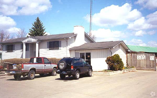
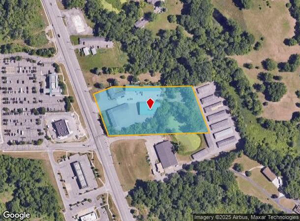
Property Record
9700 Dixie Hwy, Clarkston, MI 48348
NEARBY LISTINGS FOR SALE OR LEASE
Property Detail
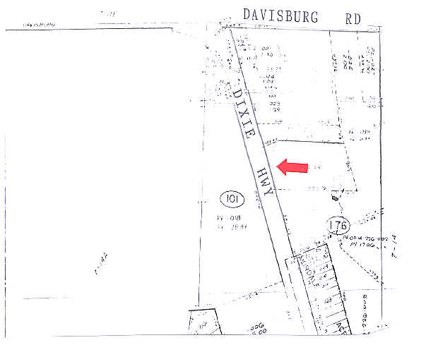
9700 Dixie Hwy
07-14-176-005
T4N, R8E, SEC 14 PART OF NW 1/4 BEG AT PT DIST N 86-48-05 W 1141.79 FT & S 15-47-45 E 412.50 FT & S 15-24-45 E 375.54 FT FROM
Warehouse
Oakland
X
Michigan
26125C0190F
4.08 AC
2024
Lakes Area
2024
Detroit
126300
Detroit-Warren-Dearborn, MI
22,848 SF
DEMOGRAPHICS near 9700 Dixie Hwy
1 Mile
3 Mile
5 Mile
2024 Total Population
2,697
15,710
37,340
2029 Population
2,657
15,614
37,105
Pop Growth 2024-2029
(1.48%)
(0.61%)
(0.63%)
Average Age
42
42
43
2024 Total Households
998
5,720
14,180
HH Growth 2024-2029
(1.60%)
(0.65%)
(0.69%)
Median Household Inc
$129,643
$109,886
$105,340
Avg Household Size
2.70
2.70
2.60
2024 Avg HH Vehicles
2.00
2.00
2.00
Median Home Value
$430,555
$368,162
$338,246
Median Year Built
1991
1989
1982
Nearby Places
- Restaurants
- Banks
- Shops
- Fitness
- Groceries
PUBLIC TRANSPORTATION
AIRPORT
Bishop International
DRIVE
WALK
Distance
Bishop International
39 min
23.8 mi
SALE & LEASE HISTORY
LISTING DATE
SALE/LEASE

Dec 30, 2021
For Sale
Nearby Properties
Address
Land Use
TOTAL SIZE
Lot Size
Zoning
Address
Land Use
TOTAL SIZE
Lot Size
Zoning
21,719 SF
26.34 AC
R2
Address
Land Use
TOTAL SIZE
Lot Size
Zoning
32,059 SF
BLL
Address
Land Use
TOTAL SIZE
Lot Size
Zoning
34,111 SF
20.14 AC
Address
Land Use
TOTAL SIZE
Lot Size
Zoning
34,807 SF
3.34 AC
OS-2
Address
Land Use
TOTAL SIZE
Lot Size
Zoning
30,726 SF
3.44 AC
R3
Address
Land Use
TOTAL SIZE
Lot Size
Zoning
6,981 SF
88.04 AC
Address
Land Use
TOTAL SIZE
Lot Size
Zoning
8,617 SF
71.35 AC
MM
Address
Land Use
TOTAL SIZE
Lot Size
Zoning
261,633 SF
1,321.20 AC
C2GEN
Address
Land Use
TOTAL SIZE
Lot Size
Zoning
26,221 SF
15.76 AC
C2
Address
Land Use
TOTAL SIZE
Lot Size
Zoning
44,258 SF
8.86 AC
C2GEN
Address
Land Use
TOTAL SIZE
Lot Size
Zoning
28.31 AC
R1C
Address
Land Use
TOTAL SIZE
Lot Size
Zoning
59,491 SF
6.94 AC
C2GEN
Address
Land Use
TOTAL SIZE
Lot Size
Zoning
74,592 SF
8.05 AC
RMMULT
Address
Land Use
TOTAL SIZE
Lot Size
Zoning
57,600 SF
15.72 AC
M1LITE
Address
Land Use
TOTAL SIZE
Lot Size
Zoning
28,694 SF
5.03 AC
C2GEN
Address
Land Use
TOTAL SIZE
Lot Size
Zoning
77,403 SF
4.58 AC
M1LITE
Address
Land Use
TOTAL SIZE
Lot Size
Zoning
14,218 SF
16.94 AC
Address
Land Use
TOTAL SIZE
Lot Size
Zoning
23.56 AC
OS-2
Address
Land Use
TOTAL SIZE
Lot Size
Zoning
64,195 SF
5.01 AC
M1LITE
Address
Land Use
TOTAL SIZE
Lot Size
Zoning
20,135 SF
4.54 AC
C2
Address
Land Use
TOTAL SIZE
Lot Size
Zoning
13,667 SF
2.33 AC
R1
Address
Land Use
TOTAL SIZE
Lot Size
Zoning
12,226 SF
1.70 AC
O
Address
Land Use
TOTAL SIZE
Lot Size
Zoning
24.97 AC
Address
Land Use
TOTAL SIZE
Lot Size
Zoning
19.27 AC
C2
Address
Land Use
TOTAL SIZE
Lot Size
Zoning
12,226 SF
1.70 AC
O
Address
Land Use
TOTAL SIZE
Lot Size
Zoning
4,068 SF
1.44 AC
C2
Address
Land Use
TOTAL SIZE
Lot Size
Zoning
11,526 SF
6.45 AC
BI
Address
Land Use
TOTAL SIZE
Lot Size
Zoning
31,378 SF
2.42 AC
M1LITE
Address
Land Use
TOTAL SIZE
Lot Size
Zoning
3,313 SF
1.09 AC
PUD
Address
Land Use
TOTAL SIZE
Lot Size
Zoning
6,268 SF
4.33 AC
OS
The World's #1 Commercial Real Estate Marketplace
Connect with us
© 2025 CoStar Group
The information above has been obtained from sources believed reliable. While we do not doubt its accuracy we have not verified it and make no guarantee, warranty or representation about it. It is your responsibility to independently confirm its accuracy and completeness. Any projections, opinions, assumptions, or estimates used are for example only and do not represent the current or future performance of the property. The value of this transaction to you depends on tax and other factors which should be evaluated by your tax, financial, and legal advisors. You and your advisors should conduct a careful, independent investigation of the property to determine to your satisfaction the suitability of the property for your needs.