Property Record
9700 E Highway 290, Austin, TX 78724
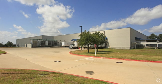

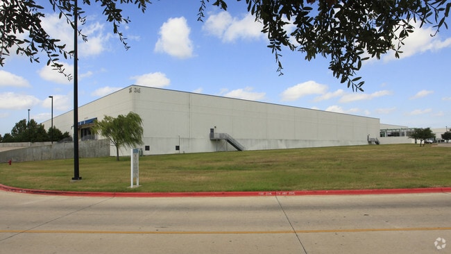
Property Detail
9700 E Highway 290
Austin-Round Rock-San Marcos, TX
LOT 3 BLK A APPLIED MATERIALS SUBD SEC 1
236732
TRAVIS
Industrialgeneral
Texas
B and X Area of moderate flood hazard, usually the area between the limits of the 100-year and 500-year floods.
3
2025
55.12 AC
2025
Northeast
042400
Austin
594,000 SF
NEARBY LISTINGS FOR SALE OR LEASE
DEMOGRAPHICS near 9700 E Highway 290
1 mile
3 mile
5 mile
2024 Total Population
3,403
27,070
147,818
2029 Population
3,531
28,775
156,724
Pop Growth 2024-2029
+ 3.76%
+ 6.30%
+ 6.02%
Average Age
37
35
36
2024 Total Households
1,147
8,832
51,919
HH Growth 2024-2029
+ 4.62%
+ 6.91%
+ 6.57%
Median Household Inc
$129,191
$97,855
$79,809
Avg Household Size
2.90
3.00
2.70
2024 Avg HH Vehicles
2.00
2.00
2.00
Median Home Value
$434,615
$382,023
$391,539
Median Year Built
2010
2008
2003
Nearby Places
Map Layers
Map Styles
 Street
 Aerial
Transit
 Traffic
 Biking
Places
Listings with unknown addresses are not visible on the map
- Restaurants
- Banks
- Shops
- Fitness
- Groceries
PUBLIC TRANSPORTATION
AIRPORT
Austin-Bergstrom International
Drive
Walk
Distance
Austin-Bergstrom International
28 min
19.1 mi
Freight Ports
Calhoun Port
Drive
Walk
Distance
Calhoun Port
189 min
162.0 mi
Nearby Properties
Address
Land Use
TOTAL SIZE
Lot Size
Zoning
Address
Land Use
TOTAL SIZE
Lot Size
Zoning
729,000 SF
16.16 AC
Address
Land Use
TOTAL SIZE
Lot Size
Zoning
398,475 SF
35.14 AC
Address
Land Use
TOTAL SIZE
Lot Size
Zoning
381,495 SF
13.54 AC
Address
Land Use
TOTAL SIZE
Lot Size
Zoning
752,804 SF
180.91 AC
Address
Land Use
TOTAL SIZE
Lot Size
Zoning
411,429 SF
61.03 AC
Address
Land Use
TOTAL SIZE
Lot Size
Zoning
376,385 SF
26.47 AC
Address
Land Use
TOTAL SIZE
Lot Size
Zoning
323,425 SF
14.20 AC
Address
Land Use
TOTAL SIZE
Lot Size
Zoning
292,050 SF
15.65 AC
Address
Land Use
TOTAL SIZE
Lot Size
Zoning
358,683 SF
17.54 AC
Address
Land Use
TOTAL SIZE
Lot Size
Zoning
769,240 SF
71.87 AC
Address
Land Use
TOTAL SIZE
Lot Size
Zoning
483,840 SF
47.88 AC
Address
Land Use
TOTAL SIZE
Lot Size
Zoning
261,594 SF
6.66 AC
Address
Land Use
TOTAL SIZE
Lot Size
Zoning
326,138 SF
15.95 AC
Address
Land Use
TOTAL SIZE
Lot Size
Zoning
255,750 SF
13.38 AC
Address
Land Use
TOTAL SIZE
Lot Size
Zoning
336,658 SF
22.91 AC
Address
Land Use
TOTAL SIZE
Lot Size
Zoning
371,200 SF
27.11 AC
Address
Land Use
TOTAL SIZE
Lot Size
Zoning
320.84 AC
Address
Land Use
TOTAL SIZE
Lot Size
Zoning
289,982 SF
21.01 AC
Address
Land Use
TOTAL SIZE
Lot Size
Zoning
343,200 SF
21.79 AC
Address
Land Use
TOTAL SIZE
Lot Size
Zoning
2,326,880 SF
180.02 AC
Address
Land Use
TOTAL SIZE
Lot Size
Zoning
319,535 SF
20.06 AC
Address
Land Use
TOTAL SIZE
Lot Size
Zoning
4,187 SF
117.72 AC
Address
Land Use
TOTAL SIZE
Lot Size
Zoning
423,360 SF
32.31 AC
Address
Land Use
TOTAL SIZE
Lot Size
Zoning
217,800 SF
16.42 AC
Address
Land Use
TOTAL SIZE
Lot Size
Zoning
237,896 SF
11.61 AC
Address
Land Use
TOTAL SIZE
Lot Size
Zoning
251,659 SF
4.27 AC
Address
Land Use
TOTAL SIZE
Lot Size
Zoning
228,710 SF
8.87 AC
Address
Land Use
TOTAL SIZE
Lot Size
Zoning
252,560 SF
19.25 AC
Address
Land Use
TOTAL SIZE
Lot Size
Zoning
253,962 SF
14.29 AC
The World's #1 Commercial Real Estate Marketplace
Connect with us
© 2026 CoStar Group
The information above has been obtained from sources believed reliable. While we do not doubt its accuracy we have not verified it and make no guarantee, warranty or representation about it. It is your responsibility to independently confirm its accuracy and completeness. Any projections, opinions, assumptions, or estimates used are for example only and do not represent the current or future performance of the property. The value of this transaction to you depends on tax and other factors which should be evaluated by your tax, financial, and legal advisors. You and your advisors should conduct a careful, independent investigation of the property to determine to your satisfaction the suitability of the property for your needs.