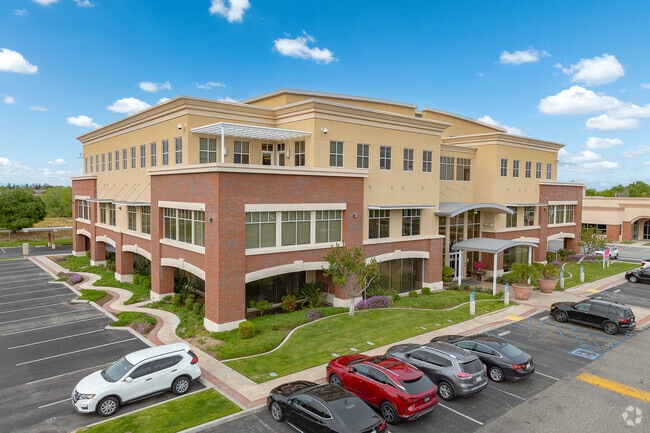
Property Record
9700 Stockdale Hwy, Bakersfield, CA 93311

NEARBY LISTINGS FOR SALE OR LEASE
Property Detail
9700 Stockdale Hwy
390-380-19-00-1
PARCEL MAP 10625 , LOT 4
Officebuilding
Kern
X
California
06029C2276F
4
2024
2.50 AC
2025
University Centre
002806
Bakersfield
46,344 SF
Bakersfield, CA
DEMOGRAPHICS near 9700 Stockdale Hwy
1 Mile
3 Mile
5 Mile
2024 Total Population
7,889
92,421
251,663
2029 Population
7,991
92,465
251,915
Pop Growth 2024-2029
+ 1.29%
+ 0.05%
+ 0.10%
Average Age
39
39
37
2024 Total Households
2,674
33,546
84,807
HH Growth 2024-2029
+ 1.27%
+ 0.01%
+ 0.02%
Median Household Inc
$110,241
$93,182
$85,268
Avg Household Size
2.70
2.70
2.90
2024 Avg HH Vehicles
2.00
2.00
2.00
Median Home Value
$369,506
$350,930
$339,734
Median Year Built
1997
1989
1990
Nearby Places
Map Layers
Map Styles
 Street
 Aerial
- Restaurants
- Banks
- Shops
- Fitness
- Groceries
PUBLIC TRANSPORTATION
COMMUTER RAIL
Bakersfield (San Joaquins - Amtrak)
DRIVE
WALK
Distance
Bakersfield (San Joaquins - Amtrak)
13 min
7.0 mi
AIRPORT
Meadows Field
DRIVE
WALK
Distance
Meadows Field
21 min
9.9 mi
Freight Ports
The Port of Hueneme
DRIVE
WALK
Distance
The Port of Hueneme
157 min
124.4 mi
Nearby Properties
Address
Land Use
TOTAL SIZE
Lot Size
Zoning
Address
Land Use
TOTAL SIZE
Lot Size
Zoning
60.03 AC
M-3
Address
Land Use
TOTAL SIZE
Lot Size
Zoning
3,788 SF
54.09 AC
M3
Address
Land Use
TOTAL SIZE
Lot Size
Zoning
1,200 SF
5.89 AC
M-1
Address
Land Use
TOTAL SIZE
Lot Size
Zoning
5,850 SF
10.96 AC
C2
Address
Land Use
TOTAL SIZE
Lot Size
Zoning
6,702 SF
18.75 AC
C-2
Address
Land Use
TOTAL SIZE
Lot Size
Zoning
14,529 SF
27.73 AC
R-2
Address
Land Use
TOTAL SIZE
Lot Size
Zoning
241,051 SF
18.48 AC
CO
Address
Land Use
TOTAL SIZE
Lot Size
Zoning
7,008 SF
46 AC
R1
Address
Land Use
TOTAL SIZE
Lot Size
Zoning
253,532 SF
14.69 AC
Address
Land Use
TOTAL SIZE
Lot Size
Zoning
35,250 SF
10.33 AC
C-2 PCD
Address
Land Use
TOTAL SIZE
Lot Size
Zoning
149,197 SF
8.21 AC
PUD
Address
Land Use
TOTAL SIZE
Lot Size
Zoning
15,027 SF
17.72 AC
C-2
Address
Land Use
TOTAL SIZE
Lot Size
Zoning
51,517 SF
8.11 AC
CO
Address
Land Use
TOTAL SIZE
Lot Size
Zoning
99,368 SF
6.95 AC
CO
Address
Land Use
TOTAL SIZE
Lot Size
Zoning
214,746 SF
14.91 AC
Address
Land Use
TOTAL SIZE
Lot Size
Zoning
138,923 SF
9.97 AC
C-2
Address
Land Use
TOTAL SIZE
Lot Size
Zoning
210,432 SF
13.52 AC
R-2
Address
Land Use
TOTAL SIZE
Lot Size
Zoning
93,274 SF
6.20 AC
R-2
Address
Land Use
TOTAL SIZE
Lot Size
Zoning
55,532 SF
4.18 AC
CO
Address
Land Use
TOTAL SIZE
Lot Size
Zoning
83,388 SF
3.15 AC
Address
Land Use
TOTAL SIZE
Lot Size
Zoning
192,500 SF
11.48 AC
R-2
Address
Land Use
TOTAL SIZE
Lot Size
Zoning
83,936 SF
4.39 AC
R-2
Address
Land Use
TOTAL SIZE
Lot Size
Zoning
193,524 SF
2.34 AC
C-O
Address
Land Use
TOTAL SIZE
Lot Size
Zoning
1,949 SF
6.43 AC
R-2
Address
Land Use
TOTAL SIZE
Lot Size
Zoning
24,888 SF
5.75 AC
WM-R2
Address
Land Use
TOTAL SIZE
Lot Size
Zoning
51,666 SF
6.08 AC
C2
Address
Land Use
TOTAL SIZE
Lot Size
Zoning
144,414 SF
11.90 AC
PCD
Address
Land Use
TOTAL SIZE
Lot Size
Zoning
115,267 SF
9.14 AC
C-2
Address
Land Use
TOTAL SIZE
Lot Size
Zoning
55,586 SF
2.49 AC
C-O
The World's #1 Commercial Real Estate Marketplace
Connect with us
© 2026 CoStar Group
The information above has been obtained from sources believed reliable. While we do not doubt its accuracy we have not verified it and make no guarantee, warranty or representation about it. It is your responsibility to independently confirm its accuracy and completeness. Any projections, opinions, assumptions, or estimates used are for example only and do not represent the current or future performance of the property. The value of this transaction to you depends on tax and other factors which should be evaluated by your tax, financial, and legal advisors. You and your advisors should conduct a careful, independent investigation of the property to determine to your satisfaction the suitability of the property for your needs.