Property Record
9701 Dessau Rd, Austin, TX 78754
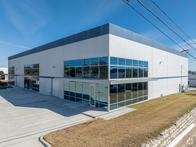


Property Detail
9701 Dessau Rd
242166
ABS 29 SUR 58 APPLEGATE J ACR 9.8972
Industrialgeneral
Travis
B and X Area of moderate flood hazard, usually the area between the limits of the 100-year and 500-year floods.
Texas
2025
9.90 AC
2025
Northeast
043500
Austin
133,000 SF
Austin-Round Rock-San Marcos, TX
NEARBY LISTINGS FOR SALE OR LEASE
DEMOGRAPHICS near 9701 Dessau Rd
1 mile
3 mile
5 mile
2025 Total Population
14,338
126,758
313,434
2030 Population
15,011
132,823
329,489
Pop Growth 2025-2030
+ 4.69%
+ 4.78%
+ 5.12%
Average Age
36
36
37
2025 Total Households
4,980
49,205
133,152
HH Growth 2025-2030
+ 5.40%
+ 5.50%
+ 5.75%
Median Household Inc
$76,329
$68,858
$79,714
Avg Household Size
2.70
2.50
2.30
2025 Avg HH Vehicles
2.00
2.00
2.00
Median Home Value
$364,407
$434,123
$505,054
Median Year Built
1992
1986
1992
Nearby Places
Map Layers
Map Styles
 Street
 Aerial
Transit
 Traffic
 Biking
Places
Listings with unknown addresses are not visible on the map
- Restaurants
- Banks
- Shops
- Fitness
- Groceries
PUBLIC TRANSPORTATION
AIRPORT
Austin-Bergstrom International
Drive
Walk
Distance
Austin-Bergstrom International
30 min
17.0 mi
SALE & LEASE HISTORY
LISTING DATE
SALE/LEASE

Oct 26, 2022
For Lease
Nearby Properties
Address
Land Use
TOTAL SIZE
Lot Size
Zoning
Address
Land Use
TOTAL SIZE
Lot Size
Zoning
348,496 SF
17.59 AC
Address
Land Use
TOTAL SIZE
Lot Size
Zoning
379,500 SF
17.99 AC
Address
Land Use
TOTAL SIZE
Lot Size
Zoning
276,772 SF
4.68 AC
Address
Land Use
TOTAL SIZE
Lot Size
Zoning
274,943 SF
42.35 AC
Address
Land Use
TOTAL SIZE
Lot Size
Zoning
459,304 SF
28.36 AC
Address
Land Use
TOTAL SIZE
Lot Size
Zoning
752,804 SF
180.91 AC
Address
Land Use
TOTAL SIZE
Lot Size
Zoning
270,780 SF
18.17 AC
Address
Land Use
TOTAL SIZE
Lot Size
Zoning
376,385 SF
26.47 AC
Address
Land Use
TOTAL SIZE
Lot Size
Zoning
384,776 SF
22.88 AC
Address
Land Use
TOTAL SIZE
Lot Size
Zoning
264,401 SF
10.48 AC
Address
Land Use
TOTAL SIZE
Lot Size
Zoning
237,603 SF
8.38 AC
Address
Land Use
TOTAL SIZE
Lot Size
Zoning
254,796 SF
11.29 AC
Address
Land Use
TOTAL SIZE
Lot Size
Zoning
277,987 SF
11.01 AC
Address
Land Use
TOTAL SIZE
Lot Size
Zoning
179,670 SF
2.89 AC
Address
Land Use
TOTAL SIZE
Lot Size
Zoning
242,484 SF
15.50 AC
Address
Land Use
TOTAL SIZE
Lot Size
Zoning
400,630 SF
15.30 AC
Address
Land Use
TOTAL SIZE
Lot Size
Zoning
379,200 SF
19.79 AC
Address
Land Use
TOTAL SIZE
Lot Size
Zoning
241,800 SF
13.27 AC
Address
Land Use
TOTAL SIZE
Lot Size
Zoning
331,943 SF
22.87 AC
Address
Land Use
TOTAL SIZE
Lot Size
Zoning
326,138 SF
15.95 AC
Address
Land Use
TOTAL SIZE
Lot Size
Zoning
316,064 SF
18.98 AC
Address
Land Use
TOTAL SIZE
Lot Size
Zoning
336,658 SF
22.91 AC
Address
Land Use
TOTAL SIZE
Lot Size
Zoning
350,341 SF
30.34 AC
Address
Land Use
TOTAL SIZE
Lot Size
Zoning
297,000 SF
16.85 AC
Address
Land Use
TOTAL SIZE
Lot Size
Zoning
168,450 SF
8.16 AC
Address
Land Use
TOTAL SIZE
Lot Size
Zoning
138,338 SF
12.52 AC
Address
Land Use
TOTAL SIZE
Lot Size
Zoning
272,286 SF
27.02 AC
Address
Land Use
TOTAL SIZE
Lot Size
Zoning
320.84 AC
Address
Land Use
TOTAL SIZE
Lot Size
Zoning
224,272 SF
13.15 AC
Address
Land Use
TOTAL SIZE
Lot Size
Zoning
2,326,880 SF
180.02 AC
The World's #1 Commercial Real Estate Marketplace
Connect with us
© 2026 CoStar Group
The information above has been obtained from sources believed reliable. While we do not doubt its accuracy we have not verified it and make no guarantee, warranty or representation about it. It is your responsibility to independently confirm its accuracy and completeness. Any projections, opinions, assumptions, or estimates used are for example only and do not represent the current or future performance of the property. The value of this transaction to you depends on tax and other factors which should be evaluated by your tax, financial, and legal advisors. You and your advisors should conduct a careful, independent investigation of the property to determine to your satisfaction the suitability of the property for your needs.