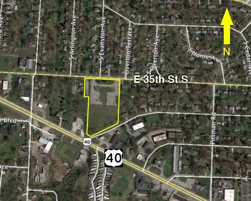
Property Record
9701 E 35Th St S, Independence, MO 64052
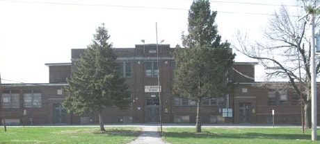

Property Detail
9701 E 35Th St S
Kansas City, MO-KS
EAST HOLLYWOOD E 50 OF LOT 110 & TH PT OF SEC 20-49-32 DAF BEG 1016 W & 30 S OF NE COR OF NE 1/4 TH S 480 TH SWLY AL G N ROW LI OF 35TH TER 360 MOL TH NWLY ALG N ROW LI OF HWY
32-210-01-33-00-0-00-000
JACKSON
Commercialacreage
Missouri
B and X Area of moderate flood hazard, usually the area between the limits of the 100-year and 500-year floods.
110
2024
4 AC
2025
East Jackson County
011900
Kansas City
24,477 SF
NEARBY LISTINGS FOR SALE OR LEASE
DEMOGRAPHICS near 9701 E 35Th St S
1 mile
3 mile
5 mile
2025 Total Population
6,816
61,551
192,904
2030 Population
6,849
62,144
196,578
Pop Growth 2025-2030
+ 0.48%
+ 0.96%
+ 1.90%
Average Age
40
40
40
2025 Total Households
2,889
25,403
77,989
HH Growth 2025-2030
+ 0.45%
+ 0.94%
+ 1.79%
Median Household Inc
$55,804
$57,431
$53,067
Avg Household Size
2.30
2.30
2.40
2025 Avg HH Vehicles
2.00
2.00
2.00
Median Home Value
$156,425
$147,915
$142,865
Median Year Built
1960
1959
1960
Nearby Places
Map Layers
Map Styles
 Street
 Aerial
Layers
 Traffic
 Biking
Places
Listings with unknown addresses are not visible on the map
- Restaurants
- Banks
- Shops
- Fitness
- Groceries
PUBLIC TRANSPORTATION
COMMUTER RAIL
Drive
Walk
Distance
8 min
4.0 mi
Drive
Walk
Distance
15 min
8.0 mi
AIRPORT
Kansas City International
Drive
Walk
Distance
Kansas City International
38 min
29.6 mi
SALE & LEASE HISTORY
LISTING DATE
SALE/LEASE

Nov 09, 2016
For Sale
Nov 08, 2016
For Sale
Jul 18, 2024
For Sale
Nearby Properties
Address
Land Use
TOTAL SIZE
Lot Size
Zoning
Address
Land Use
TOTAL SIZE
Lot Size
Zoning
963,895 SF
20.27 AC
Address
Land Use
TOTAL SIZE
Lot Size
Zoning
474,624 SF
18.82 AC
Address
Land Use
TOTAL SIZE
Lot Size
Zoning
519,315 SF
28.47 AC
Address
Land Use
TOTAL SIZE
Lot Size
Zoning
Address
Land Use
TOTAL SIZE
Lot Size
Zoning
455,100 SF
42.02 AC
Address
Land Use
TOTAL SIZE
Lot Size
Zoning
213,615 SF
15.50 AC
Address
Land Use
TOTAL SIZE
Lot Size
Zoning
74,801 SF
8.93 AC
Address
Land Use
TOTAL SIZE
Lot Size
Zoning
210,008 SF
16.89 AC
Address
Land Use
TOTAL SIZE
Lot Size
Zoning
608,833 SF
40.53 AC
Address
Land Use
TOTAL SIZE
Lot Size
Zoning
220,176 SF
8.61 AC
Address
Land Use
TOTAL SIZE
Lot Size
Zoning
138,353 SF
23.03 AC
Address
Land Use
TOTAL SIZE
Lot Size
Zoning
49,964 SF
39.88 AC
Address
Land Use
TOTAL SIZE
Lot Size
Zoning
157,666 SF
18.54 AC
Address
Land Use
TOTAL SIZE
Lot Size
Zoning
139,713 SF
15.70 AC
Address
Land Use
TOTAL SIZE
Lot Size
Zoning
134,082 SF
1.79 AC
Address
Land Use
TOTAL SIZE
Lot Size
Zoning
42,188 SF
7.82 AC
Address
Land Use
TOTAL SIZE
Lot Size
Zoning
71,339 SF
0.68 AC
Address
Land Use
TOTAL SIZE
Lot Size
Zoning
190,810 SF
26.90 AC
Address
Land Use
TOTAL SIZE
Lot Size
Zoning
Address
Land Use
TOTAL SIZE
Lot Size
Zoning
23,925 SF
19.96 AC
Address
Land Use
TOTAL SIZE
Lot Size
Zoning
103,866 SF
13.29 AC
Address
Land Use
TOTAL SIZE
Lot Size
Zoning
118,908 SF
152 AC
Address
Land Use
TOTAL SIZE
Lot Size
Zoning
101,687 SF
10.78 AC
Address
Land Use
TOTAL SIZE
Lot Size
Zoning
145,569 SF
16.90 AC
Address
Land Use
TOTAL SIZE
Lot Size
Zoning
114,248 SF
5.02 AC
Address
Land Use
TOTAL SIZE
Lot Size
Zoning
80,433 SF
7.24 AC
Address
Land Use
TOTAL SIZE
Lot Size
Zoning
71,368 SF
5.64 AC
Address
Land Use
TOTAL SIZE
Lot Size
Zoning
57,732 SF
22.42 AC
Address
Land Use
TOTAL SIZE
Lot Size
Zoning
82,432 SF
5.24 AC
Address
Land Use
TOTAL SIZE
Lot Size
Zoning
58,800 SF
5.72 AC
The World's #1 Commercial Real Estate Marketplace
Connect with us
© 2026 CoStar Group
The information above has been obtained from sources believed reliable. While we do not doubt its accuracy we have not verified it and make no guarantee, warranty or representation about it. It is your responsibility to independently confirm its accuracy and completeness. Any projections, opinions, assumptions, or estimates used are for example only and do not represent the current or future performance of the property. The value of this transaction to you depends on tax and other factors which should be evaluated by your tax, financial, and legal advisors. You and your advisors should conduct a careful, independent investigation of the property to determine to your satisfaction the suitability of the property for your needs.