Property Record
9728 Zumwalt Ave, Reedley, CA 93654
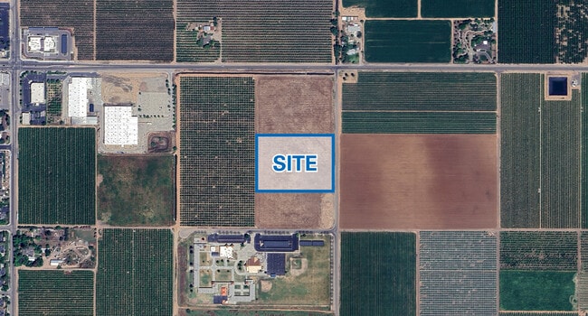
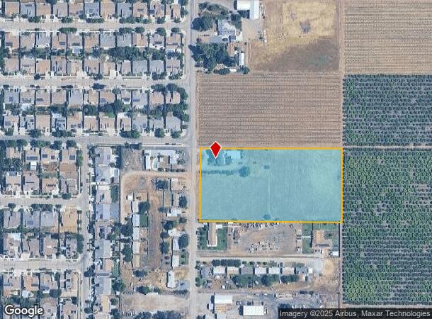
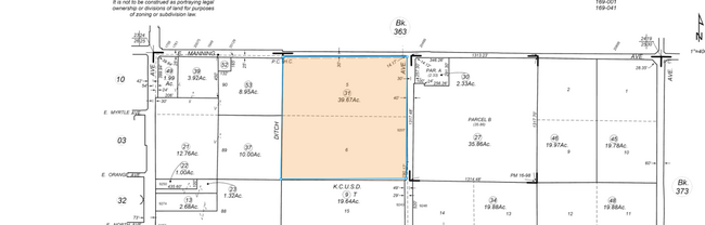
This Property Is For Sale
NEARBY LISTINGS FOR SALE OR LEASE
Property Detail
9728 Zumwalt Ave
Fresno, CA
Fresno
370-060-21
California
Sfr
4.85 AC
X
E Outlying Fresno County
06107C0310E
Fresno
1,560 SF
DEMOGRAPHICS near 9728 Zumwalt Ave
1 Mile
3 Mile
5 Mile
2024 Total Population
7,058
32,157
57,417
2029 Population
7,206
32,871
58,763
Pop Growth 2024-2029
+ 2.10%
+ 2.22%
+ 2.34%
Average Age
35
36
35
2024 Total Households
1,807
8,953
15,899
HH Growth 2024-2029
+ 2.16%
+ 2.17%
+ 2.28%
Median Household Inc
$56,040
$59,527
$57,326
Avg Household Size
3.80
3.50
3.50
2024 Avg HH Vehicles
2.00
2.00
2.00
Median Home Value
$263,363
$279,562
$273,632
Median Year Built
1985
1982
1979
Nearby Places
Map Layers
Map Styles
 Street
 Aerial
- Restaurants
- Banks
- Shops
- Fitness
- Groceries
PUBLIC TRANSPORTATION
AIRPORT
Fresno Yosemite International
DRIVE
WALK
Distance
Fresno Yosemite International
43 min
28.2 mi
Freight Ports
Port of Stockton
DRIVE
WALK
Distance
Port of Stockton
185 min
152.6 mi
Nearby Properties
Address
Land Use
TOTAL SIZE
Lot Size
Zoning
Address
Land Use
TOTAL SIZE
Lot Size
Zoning
379,550 SF
28.55 AC
MP
Address
Land Use
TOTAL SIZE
Lot Size
Zoning
89,902 SF
32.05 AC
AE20
Address
Land Use
TOTAL SIZE
Lot Size
Zoning
178,455 SF
9 AC
RM2
Address
Land Use
TOTAL SIZE
Lot Size
Zoning
196,548 SF
9.81 AC
R2P
Address
Land Use
TOTAL SIZE
Lot Size
Zoning
86,883 SF
9.37 AC
RCO
Address
Land Use
TOTAL SIZE
Lot Size
Zoning
68,550 SF
12.58 AC
MP
Address
Land Use
TOTAL SIZE
Lot Size
Zoning
122,985 SF
6.32 AC
AL20
Address
Land Use
TOTAL SIZE
Lot Size
Zoning
102,803 SF
5.61 AC
RM3
Address
Land Use
TOTAL SIZE
Lot Size
Zoning
68,453 SF
4.35 AC
RMSP
Address
Land Use
TOTAL SIZE
Lot Size
Zoning
68,775 SF
4.68 AC
RM-2
Address
Land Use
TOTAL SIZE
Lot Size
Zoning
95,562 SF
4.62 AC
R3
Address
Land Use
TOTAL SIZE
Lot Size
Zoning
57,608 SF
44.37 AC
AE-20
Address
Land Use
TOTAL SIZE
Lot Size
Zoning
62,142 SF
4.18 AC
RM2
Address
Land Use
TOTAL SIZE
Lot Size
Zoning
22,834 SF
6.66 AC
MP
Address
Land Use
TOTAL SIZE
Lot Size
Zoning
40,041 SF
4.56 AC
AL20
Address
Land Use
TOTAL SIZE
Lot Size
Zoning
19,944 SF
18.76 AC
AE20
Address
Land Use
TOTAL SIZE
Lot Size
Zoning
59,906 SF
0.78 AC
RM2
Address
Land Use
TOTAL SIZE
Lot Size
Zoning
24,521 SF
2.81 AC
R1
Address
Land Use
TOTAL SIZE
Lot Size
Zoning
22,177 SF
1.99 AC
AL20
Address
Land Use
TOTAL SIZE
Lot Size
Zoning
83,071 SF
12.05 AC
MP
Address
Land Use
TOTAL SIZE
Lot Size
Zoning
109,673 SF
21.35 AC
AE20
Address
Land Use
TOTAL SIZE
Lot Size
Zoning
70,996 SF
5.72 AC
CC
Address
Land Use
TOTAL SIZE
Lot Size
Zoning
82,994 SF
38.50 AC
AE20
Address
Land Use
TOTAL SIZE
Lot Size
Zoning
26,292 SF
2.55 AC
CC
Address
Land Use
TOTAL SIZE
Lot Size
Zoning
22,064 SF
2.22 AC
RM2
Address
Land Use
TOTAL SIZE
Lot Size
Zoning
77,845 SF
7.82 AC
CC
Address
Land Use
TOTAL SIZE
Lot Size
Zoning
51,688 SF
1.43 AC
C2
Address
Land Use
TOTAL SIZE
Lot Size
Zoning
9,018 SF
19.08 AC
MH
Address
Land Use
TOTAL SIZE
Lot Size
Zoning
58,658 SF
5.18 AC
R3
The World's #1 Commercial Real Estate Marketplace
Connect with us
© 2026 CoStar Group
The information above has been obtained from sources believed reliable. While we do not doubt its accuracy we have not verified it and make no guarantee, warranty or representation about it. It is your responsibility to independently confirm its accuracy and completeness. Any projections, opinions, assumptions, or estimates used are for example only and do not represent the current or future performance of the property. The value of this transaction to you depends on tax and other factors which should be evaluated by your tax, financial, and legal advisors. You and your advisors should conduct a careful, independent investigation of the property to determine to your satisfaction the suitability of the property for your needs.