Property Record
9705 Menchaca Rd, Austin, TX 78748
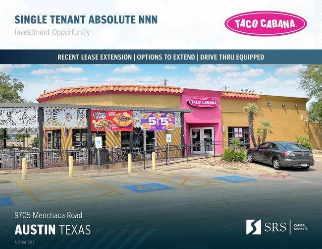

This Property Is For Sale
Property Detail
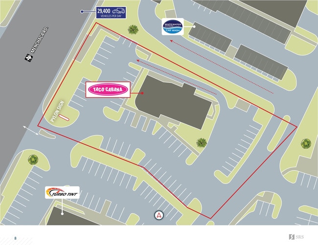
9705 Menchaca Rd
Austin-Round Rock-San Marcos, TX
LOT 3A BLK A LAURELWOOD SUBD AMENDED PLAT OF LOTS 2&3
430699
Travis
Restaurantdrivein
Texas
B and X Area of moderate flood hazard, usually the area between the limits of the 100-year and 500-year floods.
3a
2025
1 AC
2025
South
031800
Austin
3,215 SF
NEARBY LISTINGS FOR SALE OR LEASE
DEMOGRAPHICS near 9705 Menchaca Rd
1 mile
3 mile
5 mile
2024 Total Population
16,049
114,792
241,370
2029 Population
16,667
119,579
251,936
Pop Growth 2024-2029
+ 3.85%
+ 4.17%
+ 4.38%
Average Age
38
39
39
2024 Total Households
6,637
49,023
100,553
HH Growth 2024-2029
+ 4.51%
+ 4.87%
+ 5.12%
Median Household Inc
$102,345
$99,516
$95,730
Avg Household Size
2.40
2.30
2.30
2024 Avg HH Vehicles
2.00
2.00
2.00
Median Home Value
$497,061
$497,380
$529,523
Median Year Built
2001
2001
1999
Nearby Places
Map Layers
Map Styles
 Street
 Aerial
Transit
 Traffic
 Biking
Places
Listings with unknown addresses are not visible on the map
- Restaurants
- Banks
- Shops
- Fitness
- Groceries
PUBLIC TRANSPORTATION
COMMUTER RAIL
Austin (Texas Eagle - Amtrak)
Drive
Walk
Distance
Austin (Texas Eagle - Amtrak)
18 min
8.3 mi
AIRPORT
Austin-Bergstrom International
Drive
Walk
Distance
Austin-Bergstrom International
29 min
14.5 mi
Freight Ports
Calhoun Port
Drive
Walk
Distance
Calhoun Port
184 min
153.6 mi
Nearby Properties
Address
Land Use
TOTAL SIZE
Lot Size
Zoning
Address
Land Use
TOTAL SIZE
Lot Size
Zoning
441,209 SF
64.41 AC
Address
Land Use
TOTAL SIZE
Lot Size
Zoning
401,771 SF
59.77 AC
Address
Land Use
TOTAL SIZE
Lot Size
Zoning
450,836 SF
29.58 AC
Address
Land Use
TOTAL SIZE
Lot Size
Zoning
400,301 SF
22.65 AC
Address
Land Use
TOTAL SIZE
Lot Size
Zoning
380,191 SF
37.33 AC
Address
Land Use
TOTAL SIZE
Lot Size
Zoning
331,650 SF
19.33 AC
Address
Land Use
TOTAL SIZE
Lot Size
Zoning
374,720 SF
26.96 AC
Address
Land Use
TOTAL SIZE
Lot Size
Zoning
330,491 SF
19.37 AC
Address
Land Use
TOTAL SIZE
Lot Size
Zoning
307,584 SF
16.31 AC
Address
Land Use
TOTAL SIZE
Lot Size
Zoning
287,267 SF
13.28 AC
Address
Land Use
TOTAL SIZE
Lot Size
Zoning
414,030 SF
55.96 AC
Address
Land Use
TOTAL SIZE
Lot Size
Zoning
257,400 SF
10.70 AC
Address
Land Use
TOTAL SIZE
Lot Size
Zoning
399,828 SF
50.10 AC
Address
Land Use
TOTAL SIZE
Lot Size
Zoning
320,000 SF
7.44 AC
Address
Land Use
TOTAL SIZE
Lot Size
Zoning
434,872 SF
12.57 AC
Address
Land Use
TOTAL SIZE
Lot Size
Zoning
287,100 SF
13.20 AC
Address
Land Use
TOTAL SIZE
Lot Size
Zoning
327,886 SF
23.91 AC
Address
Land Use
TOTAL SIZE
Lot Size
Zoning
384,254 SF
24.13 AC
Address
Land Use
TOTAL SIZE
Lot Size
Zoning
286,614 SF
15.81 AC
Address
Land Use
TOTAL SIZE
Lot Size
Zoning
328,606 SF
42.16 AC
Address
Land Use
TOTAL SIZE
Lot Size
Zoning
333,746 SF
53.90 AC
Address
Land Use
TOTAL SIZE
Lot Size
Zoning
249,600 SF
14.48 AC
Address
Land Use
TOTAL SIZE
Lot Size
Zoning
316,572 SF
22.67 AC
Address
Land Use
TOTAL SIZE
Lot Size
Zoning
345,632 SF
25.21 AC
Address
Land Use
TOTAL SIZE
Lot Size
Zoning
312,800 SF
32.06 AC
Address
Land Use
TOTAL SIZE
Lot Size
Zoning
246,854 SF
19.40 AC
Address
Land Use
TOTAL SIZE
Lot Size
Zoning
244,746 SF
12.24 AC
Address
Land Use
TOTAL SIZE
Lot Size
Zoning
244,365 SF
11.87 AC
Address
Land Use
TOTAL SIZE
Lot Size
Zoning
239,376 SF
30.04 AC
Address
Land Use
TOTAL SIZE
Lot Size
Zoning
278,070 SF
23.97 AC
The World's #1 Commercial Real Estate Marketplace
Connect with us
© 2026 CoStar Group
The information above has been obtained from sources believed reliable. While we do not doubt its accuracy we have not verified it and make no guarantee, warranty or representation about it. It is your responsibility to independently confirm its accuracy and completeness. Any projections, opinions, assumptions, or estimates used are for example only and do not represent the current or future performance of the property. The value of this transaction to you depends on tax and other factors which should be evaluated by your tax, financial, and legal advisors. You and your advisors should conduct a careful, independent investigation of the property to determine to your satisfaction the suitability of the property for your needs.