Property Record
9705 To 9707 State Route 302 Nw, Gig Harbor, WA 98329


NEARBY LISTINGS FOR SALE OR LEASE
-
-
View all Gig Harbor listings for sale on LoopNet.com
Property Detail
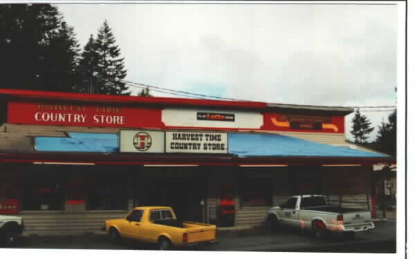
9705 To 9707 State Route 302 Nw
Seattle-Tacoma-Bellevue, WA
Pierce County Large Lot Subdivision #830
012215-3046
SECTION 15 TOWNSHIP 22 RANGE 01 QUARTER 34 : COM INTER W LI SE OF SW & N LI GHLB CO RD TH E 239.53 FT M/L TO LI OF EXISTING DRIVEWAY & POB TH NELY ALG E LI SD PRI DRIVEWAY TO A PT 170 FT N OF SD GHLB CO RD TH E TO SE COR OF SHORT PLAT 75-124 TH S 170
Servicestationmarket
Pierce
X
Washington
53053C0050E
2
2024
1.75 AC
2025
Gig Harbor/W Pierce Co
072601
Seattle/Puget Sound
6,450 SF
DEMOGRAPHICS near 9705 To 9707 State Route 302 Nw
1 Mile
3 Mile
5 Mile
2024 Total Population
2,543
14,501
40,481
2029 Population
2,593
14,764
41,307
Pop Growth 2024-2029
+ 1.97%
+ 1.81%
+ 2.04%
Average Age
43
43
43
2024 Total Households
979
5,141
14,880
HH Growth 2024-2029
+ 1.94%
+ 1.83%
+ 2.08%
Median Household Inc
$105,012
$110,682
$113,245
Avg Household Size
2.50
2.60
2.60
2024 Avg HH Vehicles
3.00
3.00
2.00
Median Home Value
$535,119
$601,294
$610,258
Median Year Built
1987
1990
1991
Nearby Places
Map Layers
Map Styles
 Street
 Aerial
- Restaurants
- Banks
- Shops
- Fitness
- Groceries
PUBLIC TRANSPORTATION
AIRPORT
Seattle-Tacoma International
DRIVE
WALK
Distance
Seattle-Tacoma International
58 min
39.2 mi
Freight Ports
Port of Tacoma
DRIVE
WALK
Distance
Port of Tacoma
30 min
20.8 mi
Nearby Properties
Address
Land Use
TOTAL SIZE
Lot Size
Zoning
Address
Land Use
TOTAL SIZE
Lot Size
Zoning
295,242 SF
62 AC
PI
Address
Land Use
TOTAL SIZE
Lot Size
Zoning
14,039 SF
162.18 AC
MPC
Address
Land Use
TOTAL SIZE
Lot Size
Zoning
55,904 SF
10.40 AC
CE
Address
Land Use
TOTAL SIZE
Lot Size
Zoning
24,354 SF
1.80 AC
MPC
Address
Land Use
TOTAL SIZE
Lot Size
Zoning
34,304 SF
5.20 AC
RAC
Address
Land Use
TOTAL SIZE
Lot Size
Zoning
1,248 SF
79.80 AC
R5
Address
Land Use
TOTAL SIZE
Lot Size
Zoning
3,784 SF
57.91 AC
RR
Address
Land Use
TOTAL SIZE
Lot Size
Zoning
32,160 SF
1.40 AC
R10
Address
Land Use
TOTAL SIZE
Lot Size
Zoning
15,476 SF
2.77 AC
RNC
Address
Land Use
TOTAL SIZE
Lot Size
Zoning
23,610 SF
2.75 AC
RAC
Address
Land Use
TOTAL SIZE
Lot Size
Zoning
42,971 SF
10.01 AC
R10
Address
Land Use
TOTAL SIZE
Lot Size
Zoning
10,106 SF
1.06 AC
RSR
Address
Land Use
TOTAL SIZE
Lot Size
Zoning
2,964 SF
5.94 AC
RP
Address
Land Use
TOTAL SIZE
Lot Size
Zoning
13,944 SF
0.66 AC
B-2
Address
Land Use
TOTAL SIZE
Lot Size
Zoning
18,650 SF
2.20 AC
RAC
Address
Land Use
TOTAL SIZE
Lot Size
Zoning
4,782 SF
24.02 AC
R5
Address
Land Use
TOTAL SIZE
Lot Size
Zoning
19,507 SF
10.24 AC
RSR
Address
Land Use
TOTAL SIZE
Lot Size
Zoning
11,719 SF
4.32 AC
R10
Address
Land Use
TOTAL SIZE
Lot Size
Zoning
14.25 AC
R10
Address
Land Use
TOTAL SIZE
Lot Size
Zoning
6,688 SF
120.37 AC
RR
Address
Land Use
TOTAL SIZE
Lot Size
Zoning
7,836 SF
1.09 AC
GIGH
Address
Land Use
TOTAL SIZE
Lot Size
Zoning
13,333 SF
4.33 AC
R5
Address
Land Use
TOTAL SIZE
Lot Size
Zoning
8,990 SF
0.94 AC
AC
Address
Land Use
TOTAL SIZE
Lot Size
Zoning
6,875 SF
10 AC
R5
Address
Land Use
TOTAL SIZE
Lot Size
Zoning
5.01 AC
R10
Address
Land Use
TOTAL SIZE
Lot Size
Zoning
4,072 SF
1.28 AC
RAC
Address
Land Use
TOTAL SIZE
Lot Size
Zoning
4,223 SF
5.43 AC
CE
Address
Land Use
TOTAL SIZE
Lot Size
Zoning
3,978 SF
1.48 AC
RAC
Address
Land Use
TOTAL SIZE
Lot Size
Zoning
3,362 SF
19.97 AC
RP
Address
Land Use
TOTAL SIZE
Lot Size
Zoning
1,152 SF
2.06 AC
R10
The World's #1 Commercial Real Estate Marketplace
Connect with us
© 2025 CoStar Group
The information above has been obtained from sources believed reliable. While we do not doubt its accuracy we have not verified it and make no guarantee, warranty or representation about it. It is your responsibility to independently confirm its accuracy and completeness. Any projections, opinions, assumptions, or estimates used are for example only and do not represent the current or future performance of the property. The value of this transaction to you depends on tax and other factors which should be evaluated by your tax, financial, and legal advisors. You and your advisors should conduct a careful, independent investigation of the property to determine to your satisfaction the suitability of the property for your needs.