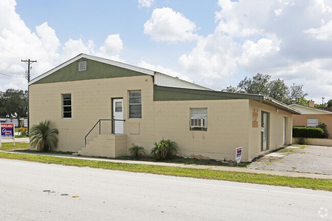
Property Record
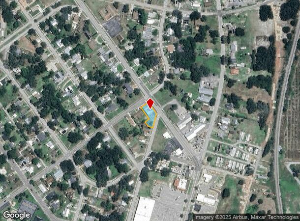
971 State Road 17 N, Sebring, FL 33870
NEARBY LISTINGS FOR SALE OR LEASE
Property Detail
971 State Road 17 N
Sebring, FL
Woodlawn Terrace Sub
S-20-34-29-150-1960-0120
WOODLAWN TERRACE SUB PB 1 PG 96 PORT OF LOT 12 + ALL LOTS 13-14 -LESS SWLY 87.2 FT OF LOTS 13 + 14 BLK 196
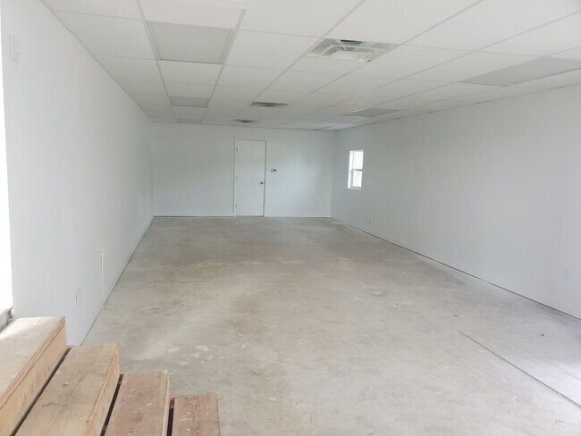
Storemultistory
Highlands
X
Florida
12055C0139C
14
2024
0.23 AC
2025
Florida Central South Area
960800
Other Market Areas
2,601 SF
DEMOGRAPHICS near 971 State Road 17 N
1 Mile
3 Mile
5 Mile
2024 Total Population
4,979
19,643
44,505
2029 Population
5,435
21,583
48,500
Pop Growth 2024-2029
+ 9.16%
+ 9.88%
+ 8.98%
Average Age
43
48
51
2024 Total Households
1,980
8,712
20,297
HH Growth 2024-2029
+ 9.44%
+ 10.03%
+ 9.13%
Median Household Inc
$44,278
$38,544
$46,967
Avg Household Size
2.20
2.10
2.10
2024 Avg HH Vehicles
1.00
1.00
1.00
Median Home Value
$140,577
$140,016
$142,310
Median Year Built
1971
1979
1985
Nearby Places
Map Layers
Map Styles
 Street
 Aerial
- Restaurants
- Banks
- Shops
- Fitness
- Groceries
PUBLIC TRANSPORTATION
COMMUTER RAIL
DRIVE
WALK
Distance
2 min
14 min
0.7 mi
SALE & LEASE HISTORY
LISTING DATE
SALE/LEASE

Sep 28, 2017
For Sale
Jul 14, 2020
For Sale
Jul 05, 2017
For Sale
Nearby Properties
Address
Land Use
TOTAL SIZE
Lot Size
Zoning
Address
Land Use
TOTAL SIZE
Lot Size
Zoning
235,165 SF
33.99 AC
B3
Address
Land Use
TOTAL SIZE
Lot Size
Zoning
123,239 SF
10.51 AC
C1
Address
Land Use
TOTAL SIZE
Lot Size
Zoning
224,707 SF
31.63 AC
PU
Address
Land Use
TOTAL SIZE
Lot Size
Zoning
114,905 SF
3.34 AC
PU
Address
Land Use
TOTAL SIZE
Lot Size
Zoning
91,734 SF
2.23 AC
R3
Address
Land Use
TOTAL SIZE
Lot Size
Zoning
114,960 SF
6.68 AC
PU
Address
Land Use
TOTAL SIZE
Lot Size
Zoning
104,876 SF
33.52 AC
B3
Address
Land Use
TOTAL SIZE
Lot Size
Zoning
128,672 SF
6.84 AC
C1
Address
Land Use
TOTAL SIZE
Lot Size
Zoning
320 SF
10.93 AC
C1
Address
Land Use
TOTAL SIZE
Lot Size
Zoning
40,295 SF
1.65 AC
C1
Address
Land Use
TOTAL SIZE
Lot Size
Zoning
58,228 SF
2.64 AC
C1
Address
Land Use
TOTAL SIZE
Lot Size
Zoning
41,224 SF
2.16 AC
C1
Address
Land Use
TOTAL SIZE
Lot Size
Zoning
78,313 SF
18.85 AC
PU
Address
Land Use
TOTAL SIZE
Lot Size
Zoning
137,240 SF
14.46 AC
B3
Address
Land Use
TOTAL SIZE
Lot Size
Zoning
78,361 SF
3.12 AC
PU
Address
Land Use
TOTAL SIZE
Lot Size
Zoning
81,888 SF
4.80 AC
C1
Address
Land Use
TOTAL SIZE
Lot Size
Zoning
76,186 SF
6.38 AC
C1
Address
Land Use
TOTAL SIZE
Lot Size
Zoning
57,978 SF
3.80 AC
MUQD
Address
Land Use
TOTAL SIZE
Lot Size
Zoning
73,229 SF
14.19 AC
PU
Address
Land Use
TOTAL SIZE
Lot Size
Zoning
64,124 SF
4.16 AC
PU
Address
Land Use
TOTAL SIZE
Lot Size
Zoning
82,784 SF
12.22 AC
R3FUD
Address
Land Use
TOTAL SIZE
Lot Size
Zoning
55,072 SF
5.16 AC
MUQD
Address
Land Use
TOTAL SIZE
Lot Size
Zoning
53,075 SF
12.27 AC
R3FUD
Address
Land Use
TOTAL SIZE
Lot Size
Zoning
388,414 SF
49.99 AC
B4FUD
Address
Land Use
TOTAL SIZE
Lot Size
Zoning
53,846 SF
2.03 AC
C1
Address
Land Use
TOTAL SIZE
Lot Size
Zoning
3,111 SF
18.55 AC
CG3
Address
Land Use
TOTAL SIZE
Lot Size
Zoning
34,234 SF
3.46 AC
C1
Address
Land Use
TOTAL SIZE
Lot Size
Zoning
40,680 SF
5.29 AC
C1
Address
Land Use
TOTAL SIZE
Lot Size
Zoning
49,983 SF
7.31 AC
MUQD
Address
Land Use
TOTAL SIZE
Lot Size
Zoning
65,640 SF
6.89 AC
MUQD
The World's #1 Commercial Real Estate Marketplace
Connect with us
© 2025 CoStar Group
The information above has been obtained from sources believed reliable. While we do not doubt its accuracy we have not verified it and make no guarantee, warranty or representation about it. It is your responsibility to independently confirm its accuracy and completeness. Any projections, opinions, assumptions, or estimates used are for example only and do not represent the current or future performance of the property. The value of this transaction to you depends on tax and other factors which should be evaluated by your tax, financial, and legal advisors. You and your advisors should conduct a careful, independent investigation of the property to determine to your satisfaction the suitability of the property for your needs.