Property Record
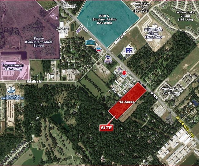
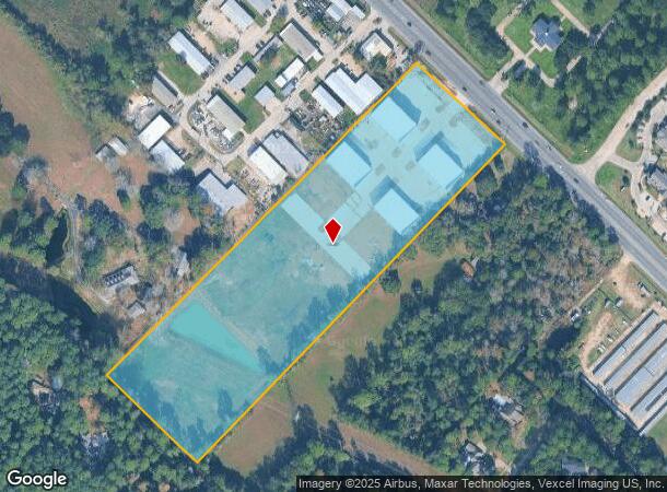
9711 Fm 2920 Rd, Tomball, TX 77375
NEARBY LISTINGS FOR SALE OR LEASE
Property Detail
9711 Fm 2920 Rd
0410260000149
Abst 70 E Smith
Outdoorrecreationbeachmountaindesert
TR 27F ABST 70 E SMITH
X
Harris
48201C0230L
Texas
2024
11.87 AC
2025
Northwest Outlier
554803
Houston
60,480 SF
Houston-Pasadena-The Woodlands, TX
DEMOGRAPHICS near 9711 Fm 2920 Rd
1 mile
3 mile
5 mile
2024 Total Population
3,934
58,667
170,289
2029 Population
4,030
61,044
175,898
Pop Growth 2024-2029
+ 2.44%
+ 4.05%
+ 3.29%
Average Age
35
36
36
2024 Total Households
1,305
19,482
56,575
HH Growth 2024-2029
+ 2.30%
+ 4.10%
+ 3.29%
Median Household Inc
$82,969
$95,680
$103,866
Avg Household Size
3.00
3.00
3.00
2024 Avg HH Vehicles
2.00
2.00
2.00
Median Home Value
$289,493
$295,576
$297,534
Median Year Built
2011
2010
2007
Nearby Places
Map Layers
Map Styles
 Street
 Aerial
Transit
 Traffic
 Biking
Places
Listings with unknown addresses are not visible on the map
- Restaurants
- Banks
- Shops
- Fitness
- Groceries
PUBLIC TRANSPORTATION
AIRPORT
George Bush Intcntl/Houston
Drive
Walk
Distance
George Bush Intcntl/Houston
31 min
25.8 mi
Freight Ports
Port of Houston
Drive
Walk
Distance
Port of Houston
54 min
41.5 mi
SALE & LEASE HISTORY
LISTING DATE
SALE/LEASE

Nov 08, 2019
For Sale
Apr 18, 2018
For Sale
Nearby Properties
Address
Land Use
TOTAL SIZE
Lot Size
Zoning
Address
Land Use
TOTAL SIZE
Lot Size
Zoning
722,325 SF
27.72 AC
Address
Land Use
TOTAL SIZE
Lot Size
Zoning
379,180 SF
15.52 AC
Address
Land Use
TOTAL SIZE
Lot Size
Zoning
398,856 SF
12.76 AC
Address
Land Use
TOTAL SIZE
Lot Size
Zoning
335,258 SF
12.18 AC
Address
Land Use
TOTAL SIZE
Lot Size
Zoning
322,733 SF
18.40 AC
Address
Land Use
TOTAL SIZE
Lot Size
Zoning
332,688 SF
24.57 AC
Address
Land Use
TOTAL SIZE
Lot Size
Zoning
294,931 SF
10.94 AC
Address
Land Use
TOTAL SIZE
Lot Size
Zoning
306,815 SF
14.88 AC
Address
Land Use
TOTAL SIZE
Lot Size
Zoning
249,950 SF
15.92 AC
Address
Land Use
TOTAL SIZE
Lot Size
Zoning
281,166 SF
22.14 AC
Address
Land Use
TOTAL SIZE
Lot Size
Zoning
393,751 SF
17.08 AC
Address
Land Use
TOTAL SIZE
Lot Size
Zoning
451,840 SF
44.47 AC
Address
Land Use
TOTAL SIZE
Lot Size
Zoning
207,662 SF
11.32 AC
Address
Land Use
TOTAL SIZE
Lot Size
Zoning
253,800 SF
43.72 AC
Address
Land Use
TOTAL SIZE
Lot Size
Zoning
233,293 SF
13.20 AC
Address
Land Use
TOTAL SIZE
Lot Size
Zoning
123,937 SF
5.52 AC
Address
Land Use
TOTAL SIZE
Lot Size
Zoning
155,960 SF
25.96 AC
Address
Land Use
TOTAL SIZE
Lot Size
Zoning
106,618 SF
12.48 AC
Address
Land Use
TOTAL SIZE
Lot Size
Zoning
3,574 SF
63.83 AC
Address
Land Use
TOTAL SIZE
Lot Size
Zoning
120,220 SF
13.49 AC
Address
Land Use
TOTAL SIZE
Lot Size
Zoning
202,728 SF
3.50 AC
Address
Land Use
TOTAL SIZE
Lot Size
Zoning
87,936 SF
3.92 AC
Address
Land Use
TOTAL SIZE
Lot Size
Zoning
160,802 SF
9.11 AC
Address
Land Use
TOTAL SIZE
Lot Size
Zoning
77,804 SF
5.73 AC
Address
Land Use
TOTAL SIZE
Lot Size
Zoning
146,605 SF
12.99 AC
Address
Land Use
TOTAL SIZE
Lot Size
Zoning
74,786 SF
5.90 AC
Address
Land Use
TOTAL SIZE
Lot Size
Zoning
194,195 SF
Address
Land Use
TOTAL SIZE
Lot Size
Zoning
55,008 SF
4.76 AC
Address
Land Use
TOTAL SIZE
Lot Size
Zoning
35,560 SF
4 AC
The World's #1 Commercial Real Estate Marketplace
Connect with us
© 2026 CoStar Group
The information above has been obtained from sources believed reliable. While we do not doubt its accuracy we have not verified it and make no guarantee, warranty or representation about it. It is your responsibility to independently confirm its accuracy and completeness. Any projections, opinions, assumptions, or estimates used are for example only and do not represent the current or future performance of the property. The value of this transaction to you depends on tax and other factors which should be evaluated by your tax, financial, and legal advisors. You and your advisors should conduct a careful, independent investigation of the property to determine to your satisfaction the suitability of the property for your needs.