Property Record
9715 Us Highway 181, Taft, TX 78390


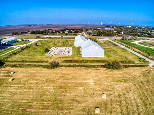
Property Detail
9715 Us Highway 181
Corpus Christi, TX
SUBD OF TRACT A TAFT E 296 LOT 5 & W 186 LOT 6 (6.092 ACRES) AKA TAFT PROPERTY SYNDICATE PT LOTS 5 & 6
56300
SAN PATRICIO
Industrialgeneral
Texas
AE The base floodplain where base flood elevations are provided. AE Zones are now used on new format FIRMs instead of A1-A30 Zones.
5
2024
6.09 AC
2025
West San Patricio Cnty
010800
Corpus Christi
32,106 SF
NEARBY LISTINGS FOR SALE OR LEASE
DEMOGRAPHICS near 9715 Us Highway 181
1 mile
3 mile
5 mile
2025 Total Population
3,580
4,564
4,843
2030 Population
3,725
4,728
5,011
Pop Growth 2025-2030
+ 4.05%
+ 3.59%
+ 3.47%
Average Age
39
39
39
2025 Total Households
1,203
1,550
1,651
HH Growth 2025-2030
+ 3.91%
+ 3.42%
+ 3.33%
Median Household Inc
$53,230
$58,587
$60,474
Avg Household Size
2.90
2.80
2.80
2025 Avg HH Vehicles
2.00
2.00
2.00
Median Home Value
$105,957
$117,073
$121,485
Median Year Built
1967
1969
1969
Nearby Places
Map Layers
Map Styles
 Street
 Aerial
Layers
 Traffic
 Biking
Places
Listings with unknown addresses are not visible on the map
- Restaurants
- Banks
- Shops
- Fitness
- Groceries
PUBLIC TRANSPORTATION
AIRPORT
Corpus Christi International
Drive
Walk
Distance
Corpus Christi International
35 min
27.3 mi
Freight Ports
Port of Corpus Christi
Drive
Walk
Distance
Port of Corpus Christi
23 min
19.3 mi
SALE & LEASE HISTORY
LISTING DATE
SALE/LEASE

Dec 17, 2021
For Sale
Apr 07, 2023
For Sale
Nearby Properties
Address
Land Use
TOTAL SIZE
Lot Size
Zoning
Address
Land Use
TOTAL SIZE
Lot Size
Zoning
48,400 SF
9 AC
Address
Land Use
TOTAL SIZE
Lot Size
Zoning
721 SF
4 AC
Address
Land Use
TOTAL SIZE
Lot Size
Zoning
36,929 SF
2.68 AC
Address
Land Use
TOTAL SIZE
Lot Size
Zoning
40,488 SF
12.93 AC
Address
Land Use
TOTAL SIZE
Lot Size
Zoning
13,929 SF
1.89 AC
Address
Land Use
TOTAL SIZE
Lot Size
Zoning
14,827 SF
1.21 AC
Address
Land Use
TOTAL SIZE
Lot Size
Zoning
12,496 SF
5.58 AC
Address
Land Use
TOTAL SIZE
Lot Size
Zoning
11,842 SF
1.03 AC
Address
Land Use
TOTAL SIZE
Lot Size
Zoning
48,112 SF
3.56 AC
Address
Land Use
TOTAL SIZE
Lot Size
Zoning
12.55 AC
Address
Land Use
TOTAL SIZE
Lot Size
Zoning
33,888 SF
3.98 AC
Address
Land Use
TOTAL SIZE
Lot Size
Zoning
15,336 SF
1.17 AC
Address
Land Use
TOTAL SIZE
Lot Size
Zoning
10,711 SF
1 AC
Address
Land Use
TOTAL SIZE
Lot Size
Zoning
4,800 SF
3.69 AC
Address
Land Use
TOTAL SIZE
Lot Size
Zoning
15,365 SF
1.17 AC
Address
Land Use
TOTAL SIZE
Lot Size
Zoning
8,886 SF
1.50 AC
Address
Land Use
TOTAL SIZE
Lot Size
Zoning
14,112 SF
0.96 AC
Address
Land Use
TOTAL SIZE
Lot Size
Zoning
2,304 SF
11.36 AC
Address
Land Use
TOTAL SIZE
Lot Size
Zoning
12,800 SF
1.58 AC
Address
Land Use
TOTAL SIZE
Lot Size
Zoning
9,712 SF
0.46 AC
Address
Land Use
TOTAL SIZE
Lot Size
Zoning
15,576 SF
1.10 AC
Address
Land Use
TOTAL SIZE
Lot Size
Zoning
416 SF
11.93 AC
Address
Land Use
TOTAL SIZE
Lot Size
Zoning
35,106 SF
3.20 AC
Address
Land Use
TOTAL SIZE
Lot Size
Zoning
6,504 SF
0.95 AC
Address
Land Use
TOTAL SIZE
Lot Size
Zoning
7,600 SF
2.77 AC
Address
Land Use
TOTAL SIZE
Lot Size
Zoning
500 SF
6.27 AC
Address
Land Use
TOTAL SIZE
Lot Size
Zoning
18,261 SF
2.75 AC
Address
Land Use
TOTAL SIZE
Lot Size
Zoning
35.85 AC
Address
Land Use
TOTAL SIZE
Lot Size
Zoning
25,489 SF
3.01 AC
The World's #1 Commercial Real Estate Marketplace
Connect with us
© 2026 CoStar Group
The information above has been obtained from sources believed reliable. While we do not doubt its accuracy we have not verified it and make no guarantee, warranty or representation about it. It is your responsibility to independently confirm its accuracy and completeness. Any projections, opinions, assumptions, or estimates used are for example only and do not represent the current or future performance of the property. The value of this transaction to you depends on tax and other factors which should be evaluated by your tax, financial, and legal advisors. You and your advisors should conduct a careful, independent investigation of the property to determine to your satisfaction the suitability of the property for your needs.