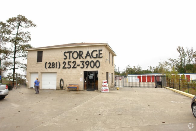
Property Record
9720 Fm 1488 Rd, Magnolia, TX 77354


NEARBY LISTINGS FOR SALE OR LEASE
-
-
View all Magnolia listings for sale on LoopNet.com
Property Detail
9720 Fm 1488 Rd
Houston-The Woodlands-Sugar Land, TX
Sierra Woods 01
8879-00-00200
S887900 - SIERRA WOODS 01, BLOCK 1, LOT 2, 5
Commercialnec
Montgomery
X
Texas
48339C0505G
2,5
2024
4.48 AC
2025
Outlying Montgomery Cnty
690403
Houston
70,118 SF
DEMOGRAPHICS near 9720 Fm 1488 Rd
1 Mile
3 Mile
5 Mile
2024 Total Population
1,526
24,023
68,809
2029 Population
1,860
29,319
84,297
Pop Growth 2024-2029
+ 21.89%
+ 22.05%
+ 22.51%
Average Age
41
37
38
2024 Total Households
493
7,960
23,065
HH Growth 2024-2029
+ 22.11%
+ 22.14%
+ 22.71%
Median Household Inc
$181,159
$105,082
$129,767
Avg Household Size
3.10
3.00
2.90
2024 Avg HH Vehicles
3.00
2.00
2.00
Median Home Value
$441,608
$366,117
$430,425
Median Year Built
2004
2006
2006
Nearby Places
Map Layers
Map Styles
 Street
 Aerial
- Restaurants
- Banks
- Shops
- Fitness
- Groceries
PUBLIC TRANSPORTATION
AIRPORT
George Bush Intcntl/Houston
DRIVE
WALK
Distance
George Bush Intcntl/Houston
46 min
35.5 mi
Freight Ports
Port of Houston
DRIVE
WALK
Distance
Port of Houston
69 min
51.2 mi
Nearby Properties
Address
Land Use
TOTAL SIZE
Lot Size
Zoning
Address
Land Use
TOTAL SIZE
Lot Size
Zoning
370,029 SF
16.12 AC
Address
Land Use
TOTAL SIZE
Lot Size
Zoning
361,747 SF
16.71 AC
Address
Land Use
TOTAL SIZE
Lot Size
Zoning
194,272 SF
11.06 AC
Address
Land Use
TOTAL SIZE
Lot Size
Zoning
222,687 SF
8.03 AC
2
Address
Land Use
TOTAL SIZE
Lot Size
Zoning
211,965 SF
25.17 AC
Address
Land Use
TOTAL SIZE
Lot Size
Zoning
172,784 SF
20.60 AC
2
Address
Land Use
TOTAL SIZE
Lot Size
Zoning
165,218 SF
17.40 AC
2
Address
Land Use
TOTAL SIZE
Lot Size
Zoning
133,487 SF
50 AC
Address
Land Use
TOTAL SIZE
Lot Size
Zoning
1,440 SF
126.83 AC
2
Address
Land Use
TOTAL SIZE
Lot Size
Zoning
106,520 SF
14.16 AC
Address
Land Use
TOTAL SIZE
Lot Size
Zoning
105,005 SF
2.84 AC
Address
Land Use
TOTAL SIZE
Lot Size
Zoning
212,968 SF
24.36 AC
Address
Land Use
TOTAL SIZE
Lot Size
Zoning
116,619 SF
14 AC
Address
Land Use
TOTAL SIZE
Lot Size
Zoning
43,510 SF
5.63 AC
Address
Land Use
TOTAL SIZE
Lot Size
Zoning
99,623 SF
14.45 AC
2
Address
Land Use
TOTAL SIZE
Lot Size
Zoning
106,745 SF
2.97 AC
Address
Land Use
TOTAL SIZE
Lot Size
Zoning
55,200 SF
5.41 AC
Address
Land Use
TOTAL SIZE
Lot Size
Zoning
31,689 SF
5.24 AC
Address
Land Use
TOTAL SIZE
Lot Size
Zoning
87,093 SF
8.28 AC
Address
Land Use
TOTAL SIZE
Lot Size
Zoning
115,892 SF
9.16 AC
Address
Land Use
TOTAL SIZE
Lot Size
Zoning
38,922 SF
8.30 AC
Address
Land Use
TOTAL SIZE
Lot Size
Zoning
34,320 SF
15.03 AC
2
Address
Land Use
TOTAL SIZE
Lot Size
Zoning
28,710 SF
2.87 AC
Address
Land Use
TOTAL SIZE
Lot Size
Zoning
14,462 SF
1.73 AC
Address
Land Use
TOTAL SIZE
Lot Size
Zoning
19,794 SF
4 AC
Address
Land Use
TOTAL SIZE
Lot Size
Zoning
66,252 SF
12.28 AC
2
Address
Land Use
TOTAL SIZE
Lot Size
Zoning
7,840 SF
1.39 AC
Address
Land Use
TOTAL SIZE
Lot Size
Zoning
27,684 SF
2.71 AC
2
Address
Land Use
TOTAL SIZE
Lot Size
Zoning
40,900 SF
5.25 AC
2
The World's #1 Commercial Real Estate Marketplace
Connect with us
© 2026 CoStar Group
The information above has been obtained from sources believed reliable. While we do not doubt its accuracy we have not verified it and make no guarantee, warranty or representation about it. It is your responsibility to independently confirm its accuracy and completeness. Any projections, opinions, assumptions, or estimates used are for example only and do not represent the current or future performance of the property. The value of this transaction to you depends on tax and other factors which should be evaluated by your tax, financial, and legal advisors. You and your advisors should conduct a careful, independent investigation of the property to determine to your satisfaction the suitability of the property for your needs.