Property Record
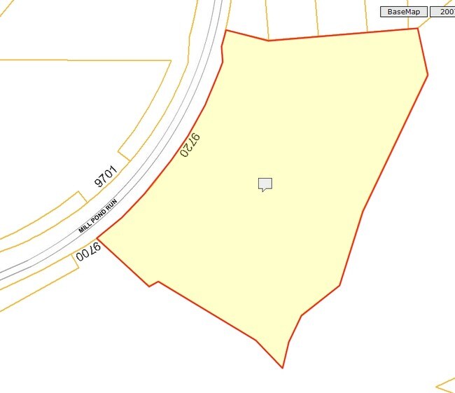
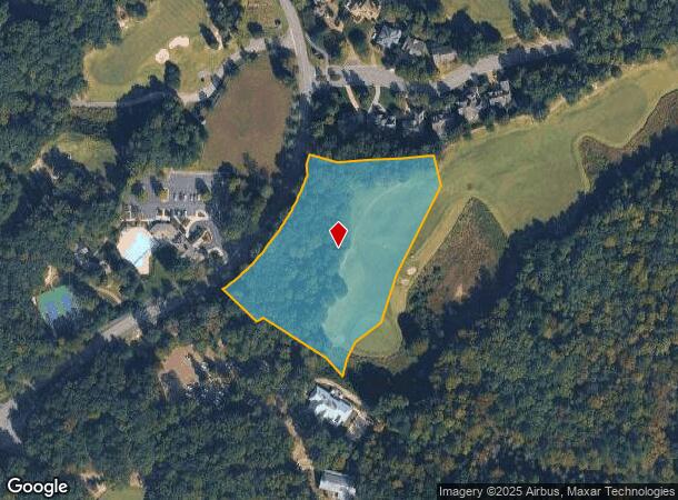
9720 Mill Pond Run, Toano, VA 23168
NEARBY LISTINGS FOR SALE OR LEASE
Property Detail
9720 Mill Pond Run
Virginia Beach-Norfolk-Newport News, VA-NC
Stonehouse
05-3-01-0-0012
FUTURE SECTION 2C STONEHOUSE
Commercialnec
James City
X
Virginia
51127C0250D
3.09 AC
2025
Williamsburg/J City Cnty
2025
Hampton Roads
080403
DEMOGRAPHICS near 9720 Mill Pond Run
1 Mile
3 Mile
5 Mile
2024 Total Population
2,386
7,791
16,471
2029 Population
2,690
8,632
18,221
Pop Growth 2024-2029
+ 12.74%
+ 10.79%
+ 10.62%
Average Age
45
41
42
2024 Total Households
827
2,728
5,905
HH Growth 2024-2029
+ 12.70%
+ 10.48%
+ 10.35%
Median Household Inc
$113,915
$96,249
$95,787
Avg Household Size
2.80
2.80
2.70
2024 Avg HH Vehicles
3.00
2.00
2.00
Median Home Value
$461,278
$378,384
$358,970
Median Year Built
2007
2004
2000
Nearby Places
Map Layers
Map Styles
 Street
 Aerial
- Restaurants
- Banks
- Shops
- Fitness
- Groceries
PUBLIC TRANSPORTATION
AIRPORT
Newport News/Williamsburg International
DRIVE
WALK
Distance
Newport News/Williamsburg International
41 min
30.6 mi
Richmond International
DRIVE
WALK
Distance
Richmond International
42 min
33.3 mi
Nearby Properties
Address
Land Use
TOTAL SIZE
Lot Size
Zoning
Address
Land Use
TOTAL SIZE
Lot Size
Zoning
17,200 SF
A1
Address
Land Use
TOTAL SIZE
Lot Size
Zoning
174,952 SF
9.52 AC
PUDC PLANN
Address
Land Use
TOTAL SIZE
Lot Size
Zoning
296,964 SF
74.37 AC
PUDC PLANN
Address
Land Use
TOTAL SIZE
Lot Size
Zoning
3,350 SF
14.95 AC
PUDC PLANN
Address
Land Use
TOTAL SIZE
Lot Size
Zoning
86,101 SF
26.22 AC
PL PUBLIC
Address
Land Use
TOTAL SIZE
Lot Size
Zoning
65,279 SF
47.01 AC
B1 GENERAL
Address
Land Use
TOTAL SIZE
Lot Size
Zoning
2,305 AC
A1 GENERAL
Address
Land Use
TOTAL SIZE
Lot Size
Zoning
35,133 SF
6.65 AC
PUDC PLANN
Address
Land Use
TOTAL SIZE
Lot Size
Zoning
85,995 SF
4.60 AC
PUDC PLANN
Address
Land Use
TOTAL SIZE
Lot Size
Zoning
85,629 SF
11.73 AC
PUDC PLANN
Address
Land Use
TOTAL SIZE
Lot Size
Zoning
193.75 AC
EO ECONOMI
Address
Land Use
TOTAL SIZE
Lot Size
Zoning
48,075 SF
8.69 AC
B1 GENERAL
Address
Land Use
TOTAL SIZE
Lot Size
Zoning
39,240 SF
4.13 AC
PUDC PLANN
Address
Land Use
TOTAL SIZE
Lot Size
Zoning
1,196 SF
16.85 AC
IND
Address
Land Use
TOTAL SIZE
Lot Size
Zoning
93.45 AC
PUDR PLANN
Address
Land Use
TOTAL SIZE
Lot Size
Zoning
27,414 SF
162.30 AC
A1 GENERAL
Address
Land Use
TOTAL SIZE
Lot Size
Zoning
291 AC
PUDR PLANN
Address
Land Use
TOTAL SIZE
Lot Size
Zoning
3,360 SF
217.93 AC
A1 GENERAL
Address
Land Use
TOTAL SIZE
Lot Size
Zoning
130.60 AC
EO ECONOMI
Address
Land Use
TOTAL SIZE
Lot Size
Zoning
266.21 AC
A1
Address
Land Use
TOTAL SIZE
Lot Size
Zoning
95 AC
A1
Address
Land Use
TOTAL SIZE
Lot Size
Zoning
157.61 AC
A1 GENERAL
Address
Land Use
TOTAL SIZE
Lot Size
Zoning
7,840 SF
21.36 AC
M2 GENERAL
Address
Land Use
TOTAL SIZE
Lot Size
Zoning
20,350 SF
2.62 AC
M2 GENERAL
Address
Land Use
TOTAL SIZE
Lot Size
Zoning
1,344 SF
188.68 AC
A1 GENERAL
Address
Land Use
TOTAL SIZE
Lot Size
Zoning
3,982 SF
134 AC
A1 GENERAL
Address
Land Use
TOTAL SIZE
Lot Size
Zoning
253.68 AC
A1
Address
Land Use
TOTAL SIZE
Lot Size
Zoning
6,612 SF
6.27 AC
B1 GENERAL
Address
Land Use
TOTAL SIZE
Lot Size
Zoning
4,172 SF
29.69 AC
A1 GENERAL
Address
Land Use
TOTAL SIZE
Lot Size
Zoning
18,450 SF
10.22 AC
A1 GENERAL
The World's #1 Commercial Real Estate Marketplace
Connect with us
© 2025 CoStar Group
The information above has been obtained from sources believed reliable. While we do not doubt its accuracy we have not verified it and make no guarantee, warranty or representation about it. It is your responsibility to independently confirm its accuracy and completeness. Any projections, opinions, assumptions, or estimates used are for example only and do not represent the current or future performance of the property. The value of this transaction to you depends on tax and other factors which should be evaluated by your tax, financial, and legal advisors. You and your advisors should conduct a careful, independent investigation of the property to determine to your satisfaction the suitability of the property for your needs.