Property Record
9720 Morningside Loop, Anchorage, AK 99515


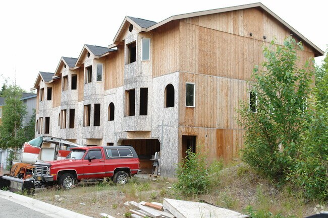
Property Detail
9720 Morningside Loop
01626156000
HILLCREST PARK TR 2
Apartment
Anchorage
R3
Alaska
B and X Area of moderate flood hazard, usually the area between the limits of the 100-year and 500-year floods.
4.84 AC
2024
Bayshore/Klatt
2025
Anchorage
002712
Anchorage, AK
5,812 SF
NEARBY LISTINGS FOR SALE OR LEASE
-
-
View all Anchorage listings for sale on LoopNet.com
DEMOGRAPHICS near 9720 Morningside Loop
1 mile
3 mile
5 mile
2025 Total Population
9,694
81,474
150,321
2030 Population
9,636
81,096
150,156
Pop Growth 2025-2030
(0.60%)
(0.46%)
(0.11%)
Average Age
36
38
39
2025 Total Households
3,904
30,351
57,741
HH Growth 2025-2030
(0.67%)
(0.42%)
(0.06%)
Median Household Inc
$87,188
$108,830
$105,416
Avg Household Size
2.40
2.60
2.50
2025 Avg HH Vehicles
2.00
2.00
2.00
Median Home Value
$285,339
$395,401
$405,341
Median Year Built
1988
1985
1981
Nearby Places
Map Layers
Map Styles
 Street
 Aerial
Transit
 Traffic
 Biking
Places
Listings with unknown addresses are not visible on the map
- Restaurants
- Banks
- Shops
- Fitness
- Groceries
Nearby Properties
Address
Land Use
TOTAL SIZE
Lot Size
Zoning
Address
Land Use
TOTAL SIZE
Lot Size
Zoning
381,477 SF
33.30 AC
B3
Address
Land Use
TOTAL SIZE
Lot Size
Zoning
267,442 SF
61.04 AC
PLI
Address
Land Use
TOTAL SIZE
Lot Size
Zoning
265,000 SF
49.89 AC
PLISL
Address
Land Use
TOTAL SIZE
Lot Size
Zoning
271,555 SF
55.40 AC
PLI
Address
Land Use
TOTAL SIZE
Lot Size
Zoning
242,189 SF
21.83 AC
I2
Address
Land Use
TOTAL SIZE
Lot Size
Zoning
168,640 SF
3.38 AC
I2
Address
Land Use
TOTAL SIZE
Lot Size
Zoning
69 AC
PR
Address
Land Use
TOTAL SIZE
Lot Size
Zoning
217,754 SF
14.42 AC
I1
Address
Land Use
TOTAL SIZE
Lot Size
Zoning
150,075 SF
29.17 AC
PLI
Address
Land Use
TOTAL SIZE
Lot Size
Zoning
164,774 SF
29.26 AC
PLI
Address
Land Use
TOTAL SIZE
Lot Size
Zoning
31,780 SF
16.44 AC
R3
Address
Land Use
TOTAL SIZE
Lot Size
Zoning
154,455 SF
16.38 AC
I1
Address
Land Use
TOTAL SIZE
Lot Size
Zoning
13,657 SF
12.35 AC
R3
Address
Land Use
TOTAL SIZE
Lot Size
Zoning
79,808 SF
19.54 AC
I2
Address
Land Use
TOTAL SIZE
Lot Size
Zoning
170,381 SF
10.70 AC
I2
Address
Land Use
TOTAL SIZE
Lot Size
Zoning
151,322 SF
9.18 AC
I1
Address
Land Use
TOTAL SIZE
Lot Size
Zoning
178,437 SF
16.02 AC
B3SL
Address
Land Use
TOTAL SIZE
Lot Size
Zoning
149,219 SF
14.56 AC
B3
Address
Land Use
TOTAL SIZE
Lot Size
Zoning
136,593 SF
9.15 AC
I2
Address
Land Use
TOTAL SIZE
Lot Size
Zoning
52,890 SF
10.64 AC
PLI
Address
Land Use
TOTAL SIZE
Lot Size
Zoning
63,305 SF
12.11 AC
I1
Address
Land Use
TOTAL SIZE
Lot Size
Zoning
79,776 SF
27 AC
I1
Address
Land Use
TOTAL SIZE
Lot Size
Zoning
109,447 SF
4.54 AC
B3SL
Address
Land Use
TOTAL SIZE
Lot Size
Zoning
83,970 SF
12.16 AC
I1
Address
Land Use
TOTAL SIZE
Lot Size
Zoning
50,413 SF
2.42 AC
B3
Address
Land Use
TOTAL SIZE
Lot Size
Zoning
64,207 SF
5.40 AC
I1
Address
Land Use
TOTAL SIZE
Lot Size
Zoning
166,065 SF
11.71 AC
B3
Address
Land Use
TOTAL SIZE
Lot Size
Zoning
171,492 SF
17.08 AC
I1
Address
Land Use
TOTAL SIZE
Lot Size
Zoning
152,964 SF
16.02 AC
I1
Address
Land Use
TOTAL SIZE
Lot Size
Zoning
53,693 SF
16.41 AC
I2
The World's #1 Commercial Real Estate Marketplace
Connect with us
© 2026 CoStar Group
The information above has been obtained from sources believed reliable. While we do not doubt its accuracy we have not verified it and make no guarantee, warranty or representation about it. It is your responsibility to independently confirm its accuracy and completeness. Any projections, opinions, assumptions, or estimates used are for example only and do not represent the current or future performance of the property. The value of this transaction to you depends on tax and other factors which should be evaluated by your tax, financial, and legal advisors. You and your advisors should conduct a careful, independent investigation of the property to determine to your satisfaction the suitability of the property for your needs.