Property Record
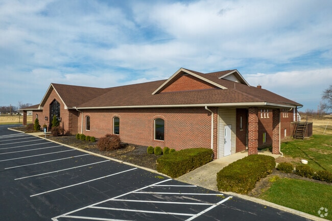
9720 State Route 161 E, Plain City, OH 43064


Property Detail
9720 State Route 161 E
02-00368.000
3.427A 3245
Officebuilding
Madison
B and X Area of moderate flood hazard, usually the area between the limits of the 100-year and 500-year floods.
Ohio
2025
3.43 AC
2025
Madison County
040102
Columbus
9,788 SF
Columbus, OH
NEARBY LISTINGS FOR SALE OR LEASE
DEMOGRAPHICS near 9720 State Route 161 E
1 mile
3 mile
5 mile
2025 Total Population
111
12,156
70,074
2030 Population
123
13,289
74,110
Pop Growth 2025-2030
+ 10.81%
+ 9.32%
+ 5.76%
Average Age
40
39
38
2025 Total Households
40
4,439
26,017
HH Growth 2025-2030
+ 12.50%
+ 9.06%
+ 5.60%
Median Household Inc
$107,812
$122,321
$121,165
Avg Household Size
2.70
2.70
2.70
2025 Avg HH Vehicles
2.00
2.00
2.00
Median Home Value
$416,667
$465,073
$469,490
Median Year Built
1998
2006
2002
Nearby Places
Map Layers
Map Styles
 Street
 Aerial
Layers
 Traffic
 Biking
Places
Listings with unknown addresses are not visible on the map
- Restaurants
- Banks
- Shops
- Fitness
- Groceries
PUBLIC TRANSPORTATION
AIRPORT
John Glenn Columbus International
Drive
Walk
Distance
John Glenn Columbus International
36 min
26.6 mi
Rickenbacker International
Drive
Walk
Distance
Rickenbacker International
43 min
32.1 mi
SALE & LEASE HISTORY
LISTING DATE
SALE/LEASE

Apr 22, 2019
For Sale
Nearby Properties
Address
Land Use
TOTAL SIZE
Lot Size
Zoning
Address
Land Use
TOTAL SIZE
Lot Size
Zoning
768,498 SF
66.96 AC
Address
Land Use
TOTAL SIZE
Lot Size
Zoning
256,984 SF
10.49 AC
Address
Land Use
TOTAL SIZE
Lot Size
Zoning
86.18 AC
Address
Land Use
TOTAL SIZE
Lot Size
Zoning
7,048 SF
35.41 AC
Address
Land Use
TOTAL SIZE
Lot Size
Zoning
Address
Land Use
TOTAL SIZE
Lot Size
Zoning
4,788 SF
96.85 AC
Address
Land Use
TOTAL SIZE
Lot Size
Zoning
121,104 SF
Address
Land Use
TOTAL SIZE
Lot Size
Zoning
7,048 SF
35.41 AC
Address
Land Use
TOTAL SIZE
Lot Size
Zoning
58,481 SF
26.99 AC
Address
Land Use
TOTAL SIZE
Lot Size
Zoning
55,622 SF
8.98 AC
Address
Land Use
TOTAL SIZE
Lot Size
Zoning
130,839 SF
13.35 AC
Address
Land Use
TOTAL SIZE
Lot Size
Zoning
1,642 SF
92.78 AC
Address
Land Use
TOTAL SIZE
Lot Size
Zoning
50,238 SF
5 AC
Address
Land Use
TOTAL SIZE
Lot Size
Zoning
44,648 SF
38.47 AC
Address
Land Use
TOTAL SIZE
Lot Size
Zoning
63,468 SF
7.86 AC
Address
Land Use
TOTAL SIZE
Lot Size
Zoning
18,325 SF
19.45 AC
Address
Land Use
TOTAL SIZE
Lot Size
Zoning
9,720 SF
13.18 AC
Address
Land Use
TOTAL SIZE
Lot Size
Zoning
486,569 SF
96.85 AC
Address
Land Use
TOTAL SIZE
Lot Size
Zoning
16.85 AC
Address
Land Use
TOTAL SIZE
Lot Size
Zoning
139,000 SF
9.34 AC
Address
Land Use
TOTAL SIZE
Lot Size
Zoning
Address
Land Use
TOTAL SIZE
Lot Size
Zoning
82,029 SF
5.33 AC
Address
Land Use
TOTAL SIZE
Lot Size
Zoning
79,759 SF
18.87 AC
Address
Land Use
TOTAL SIZE
Lot Size
Zoning
5,585 SF
9.36 AC
Address
Land Use
TOTAL SIZE
Lot Size
Zoning
150,380 SF
15.97 AC
Address
Land Use
TOTAL SIZE
Lot Size
Zoning
56,852 SF
16.26 AC
Address
Land Use
TOTAL SIZE
Lot Size
Zoning
32,132 SF
3.28 AC
Address
Land Use
TOTAL SIZE
Lot Size
Zoning
3,133 SF
18.26 AC
Address
Land Use
TOTAL SIZE
Lot Size
Zoning
124,400 SF
8.54 AC
Address
Land Use
TOTAL SIZE
Lot Size
Zoning
33,120 SF
3.62 AC
The World's #1 Commercial Real Estate Marketplace
Connect with us
© 2026 CoStar Group
The information above has been obtained from sources believed reliable. While we do not doubt its accuracy we have not verified it and make no guarantee, warranty or representation about it. It is your responsibility to independently confirm its accuracy and completeness. Any projections, opinions, assumptions, or estimates used are for example only and do not represent the current or future performance of the property. The value of this transaction to you depends on tax and other factors which should be evaluated by your tax, financial, and legal advisors. You and your advisors should conduct a careful, independent investigation of the property to determine to your satisfaction the suitability of the property for your needs.