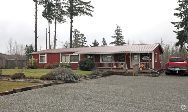
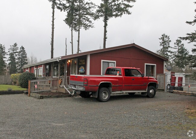
Property Record
9722 224Th St E, Graham, WA 98338

NEARBY LISTINGS FOR SALE OR LEASE
-
-
View all Graham listings for sale on LoopNet.com
Property Detail
9722 224Th St E
041816-1024
SECTION 16 TOWNSHIP 18 RANGE 04 QUARTER 12 : E 110.53 FT OF FOLL DESC THAT PART OF NW OF NE N OF R/W OF TACOMA E RR CO EXC N 30 FT FOR MUCK KAPOWSIN CO RD SEG G 1845 T/E 1985 FLTWD CHADWICK S#IDFL2AF121308431 27X66 (P50000- 44390) VS 10/99 NOT ASSESS
Miscellaneous
Pierce
X
Washington
53053C0600E
0.86 AC
2024
E Pierce County
2025
Seattle/Puget Sound
073116
Seattle-Tacoma-Bellevue, WA
1 SF
DEMOGRAPHICS near 9722 224Th St E
1 Mile
3 Mile
5 Mile
2024 Total Population
3,115
44,650
104,415
2029 Population
3,179
45,520
107,129
Pop Growth 2024-2029
+ 2.05%
+ 1.95%
+ 2.60%
Average Age
39
36
37
2024 Total Households
1,029
14,350
33,982
HH Growth 2024-2029
+ 2.14%
+ 1.97%
+ 2.61%
Median Household Inc
$105,933
$102,031
$102,650
Avg Household Size
2.90
3.00
3.00
2024 Avg HH Vehicles
3.00
2.00
2.00
Median Home Value
$440,909
$444,925
$443,960
Median Year Built
1994
1998
1998
Nearby Places
Map Layers
Map Styles
 Street
 Aerial
- Restaurants
- Banks
- Shops
- Fitness
- Groceries
PUBLIC TRANSPORTATION
AIRPORT
Seattle-Tacoma International
DRIVE
WALK
Distance
Seattle-Tacoma International
55 min
32.8 mi
Freight Ports
Port of Tacoma
DRIVE
WALK
Distance
Port of Tacoma
33 min
18.1 mi
Nearby Properties
Address
Land Use
TOTAL SIZE
Lot Size
Zoning
Address
Land Use
TOTAL SIZE
Lot Size
Zoning
782,773 SF
53.33 AC
Address
Land Use
TOTAL SIZE
Lot Size
Zoning
753,069 SF
40.94 AC
Address
Land Use
TOTAL SIZE
Lot Size
Zoning
611,206 SF
30.76 AC
Address
Land Use
TOTAL SIZE
Lot Size
Zoning
305,680 SF
14.48 AC
Address
Land Use
TOTAL SIZE
Lot Size
Zoning
153,138 SF
9.11 AC
CC
Address
Land Use
TOTAL SIZE
Lot Size
Zoning
218,262 SF
3.58 AC
MUD
Address
Land Use
TOTAL SIZE
Lot Size
Zoning
241,111 SF
16.67 AC
R10
Address
Land Use
TOTAL SIZE
Lot Size
Zoning
375,000 SF
26.29 AC
EC
Address
Land Use
TOTAL SIZE
Lot Size
Zoning
106,599 SF
20.88 AC
MSF
Address
Land Use
TOTAL SIZE
Lot Size
Zoning
69,447 SF
11.58 AC
NMHR
Address
Land Use
TOTAL SIZE
Lot Size
Zoning
282,007 SF
14.20 AC
R10
Address
Land Use
TOTAL SIZE
Lot Size
Zoning
92,841 SF
12.36 AC
CC
Address
Land Use
TOTAL SIZE
Lot Size
Zoning
83,601 SF
3.18 AC
MHR
Address
Land Use
TOTAL SIZE
Lot Size
Zoning
81,168 SF
15 AC
MSF
Address
Land Use
TOTAL SIZE
Lot Size
Zoning
156,323 SF
4.17 AC
MUD
Address
Land Use
TOTAL SIZE
Lot Size
Zoning
82,882 SF
20.87 AC
R10
Address
Land Use
TOTAL SIZE
Lot Size
Zoning
47,442 SF
19.03 AC
R10
Address
Land Use
TOTAL SIZE
Lot Size
Zoning
126,030 SF
5.88 AC
MHR
Address
Land Use
TOTAL SIZE
Lot Size
Zoning
107,586 SF
0.70 AC
MUD
Address
Land Use
TOTAL SIZE
Lot Size
Zoning
14.49 AC
EC
Address
Land Use
TOTAL SIZE
Lot Size
Zoning
58,754 SF
25.09 AC
SF
Address
Land Use
TOTAL SIZE
Lot Size
Zoning
9,964 SF
36.23 AC
EC
Address
Land Use
TOTAL SIZE
Lot Size
Zoning
37.28 AC
EC
Address
Land Use
TOTAL SIZE
Lot Size
Zoning
24,022 SF
5 AC
MUD
Address
Land Use
TOTAL SIZE
Lot Size
Zoning
56,261 SF
13.57 AC
R10
Address
Land Use
TOTAL SIZE
Lot Size
Zoning
59,468 SF
17.99 AC
R10
Address
Land Use
TOTAL SIZE
Lot Size
Zoning
42,946 SF
9.55 AC
R10
Address
Land Use
TOTAL SIZE
Lot Size
Zoning
34,480 SF
1.86 AC
MUD
Address
Land Use
TOTAL SIZE
Lot Size
Zoning
52,482 SF
1.91 AC
MUD
Address
Land Use
TOTAL SIZE
Lot Size
Zoning
52,648 SF
9.90 AC
MSF
The World's #1 Commercial Real Estate Marketplace
Connect with us
© 2025 CoStar Group
The information above has been obtained from sources believed reliable. While we do not doubt its accuracy we have not verified it and make no guarantee, warranty or representation about it. It is your responsibility to independently confirm its accuracy and completeness. Any projections, opinions, assumptions, or estimates used are for example only and do not represent the current or future performance of the property. The value of this transaction to you depends on tax and other factors which should be evaluated by your tax, financial, and legal advisors. You and your advisors should conduct a careful, independent investigation of the property to determine to your satisfaction the suitability of the property for your needs.