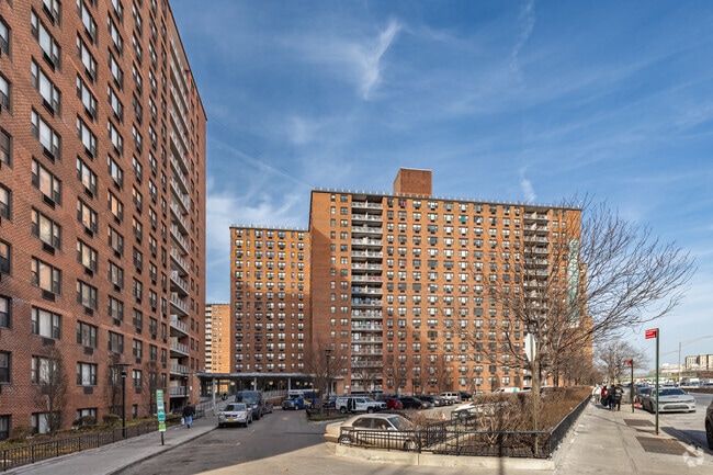
Property Record
9730 57Th Ave, Corona, NY 11368

NEARBY LISTINGS FOR SALE OR LEASE
-
-
-
-
No Photo
-
-
-
-
-
-
-
-
-
-
-
-
-
-
-
-
-
-
-
-
-
-
-
-
-
-
-
View all Corona listings for sale on LoopNet.com
Property Detail
9730 57Th Ave
01918-0065
Queens
Cooperative
New York
X
72
3604970226F
1.16 AC
2024
Corona
2025
Long Island (New York)
045500
New York-Jersey City-White Plains, NY-NJ
224,443 SF
DEMOGRAPHICS near 9730 57Th Ave
1 mile
3 mile
5 mile
2024 Total Population
196,750
891,284
2,061,591
2029 Population
184,534
836,442
1,927,221
Pop Growth 2024-2029
(6.21%)
(6.15%)
(6.52%)
Average Age
41
42
40
2024 Total Households
68,277
316,461
742,390
HH Growth 2024-2029
(6.13%)
(6.23%)
(6.62%)
Median Household Inc
$65,636
$67,918
$72,120
Avg Household Size
2.80
2.70
2.70
2024 Avg HH Vehicles
1.00
1.00
1.00
Median Home Value
$569,901
$643,905
$708,854
Median Year Built
1958
1953
1951
Nearby Places
Map Layers
Map Styles
 Street
 Aerial
Transit
 Traffic
 Biking
Places
Listings with unknown addresses are not visible on the map
- Restaurants
- Banks
- Shops
- Fitness
- Groceries
PUBLIC TRANSPORTATION
TRANSIT/SUBWAY
Woodhaven Boulevard (E,G,R Line) (E - New York MTA Subway (The Subway), M - New York MTA Subway (The Subway), R - New York MTA Subway (The Subway))
Drive
Walk
Distance
Woodhaven Boulevard (E,G,R Line) (E - New York MTA Subway (The Subway), M - New York MTA Subway (The Subway), R - New York MTA Subway (The Subway))
3 min
11 min
0.6 mi
63 Drive-Rego Park (E - New York MTA Subway (The Subway), M - New York MTA Subway (The Subway), R - New York MTA Subway (The Subway))
Drive
Walk
Distance
63 Drive-Rego Park (E - New York MTA Subway (The Subway), M - New York MTA Subway (The Subway), R - New York MTA Subway (The Subway))
2 min
13 min
0.7 mi
Grand Avenue-Newtown (E - New York MTA Subway (The Subway), M - New York MTA Subway (The Subway), R - New York MTA Subway (The Subway))
Drive
Walk
Distance
Grand Avenue-Newtown (E - New York MTA Subway (The Subway), M - New York MTA Subway (The Subway), R - New York MTA Subway (The Subway))
3 min
17 min
0.9 mi
103 Street-Corona Plaza (7 - New York MTA Subway (The Subway))
Drive
Walk
Distance
103 Street-Corona Plaza (7 - New York MTA Subway (The Subway))
3 min
17 min
0.9 mi
Junction Boulevard (7 - New York MTA Subway (The Subway))
Drive
Walk
Distance
Junction Boulevard (7 - New York MTA Subway (The Subway))
3 min
19 min
1.0 mi
COMMUTER RAIL
Forest Hills Station (Babylon Branch - Long Island Rail Road, Hempstead Branch - Long Island Rail Road, Long Beach Branch - Long Island Rail Road, Port Jefferson Branch - Long Island Rail Road)
Drive
Walk
Distance
Forest Hills Station (Babylon Branch - Long Island Rail Road, Hempstead Branch - Long Island Rail Road, Long Beach Branch - Long Island Rail Road, Port Jefferson Branch - Long Island Rail Road)
6 min
2.1 mi
Mets-Willets Point Station (Port Washington Branch - Long Island Rail Road)
Drive
Walk
Distance
Mets-Willets Point Station (Port Washington Branch - Long Island Rail Road)
8 min
3.1 mi
AIRPORT
LaGuardia
Drive
Walk
Distance
LaGuardia
8 min
3.0 mi
John F Kennedy International
Drive
Walk
Distance
John F Kennedy International
15 min
10.1 mi
Newark Liberty International
Drive
Walk
Distance
Newark Liberty International
34 min
22.0 mi
Freight Ports
NY - Red Hook Container Terminal
Drive
Walk
Distance
NY - Red Hook Container Terminal
19 min
10.8 mi
Nearby Properties
Address
Land Use
TOTAL SIZE
Lot Size
Zoning
Address
Land Use
TOTAL SIZE
Lot Size
Zoning
2,078,606 SF
58.93 AC
R4
Address
Land Use
TOTAL SIZE
Lot Size
Zoning
1,258,350 SF
410.24 AC
PARK
Address
Land Use
TOTAL SIZE
Lot Size
Zoning
1,502,532 SF
6.35 AC
R7B
Address
Land Use
TOTAL SIZE
Lot Size
Zoning
772,163 SF
5.24 AC
C4-5X
Address
Land Use
TOTAL SIZE
Lot Size
Zoning
54,170 SF
229.57 AC
PARK
Address
Land Use
TOTAL SIZE
Lot Size
Zoning
1,292,074 SF
C4-2F
Address
Land Use
TOTAL SIZE
Lot Size
Zoning
234,891 SF
3.17 AC
C4-5X
Address
Land Use
TOTAL SIZE
Lot Size
Zoning
1,516,458 SF
5.97 AC
R7-1
Address
Land Use
TOTAL SIZE
Lot Size
Zoning
8.28 AC
R7-1
Address
Land Use
TOTAL SIZE
Lot Size
Zoning
8.28 AC
R7-1
Address
Land Use
TOTAL SIZE
Lot Size
Zoning
8.28 AC
R7-1
Address
Land Use
TOTAL SIZE
Lot Size
Zoning
15,000 SF
255.27 AC
PARK
Address
Land Use
TOTAL SIZE
Lot Size
Zoning
126.85 AC
PARK
Address
Land Use
TOTAL SIZE
Lot Size
Zoning
743,160 SF
11.73 AC
R5
Address
Land Use
TOTAL SIZE
Lot Size
Zoning
743,160 SF
11.73 AC
R5
Address
Land Use
TOTAL SIZE
Lot Size
Zoning
743,160 SF
11.73 AC
R5
Address
Land Use
TOTAL SIZE
Lot Size
Zoning
743,160 SF
11.73 AC
R5
Address
Land Use
TOTAL SIZE
Lot Size
Zoning
743,160 SF
11.73 AC
R5
Address
Land Use
TOTAL SIZE
Lot Size
Zoning
743,160 SF
11.73 AC
R5
Address
Land Use
TOTAL SIZE
Lot Size
Zoning
743,160 SF
11.73 AC
R5
Address
Land Use
TOTAL SIZE
Lot Size
Zoning
743,160 SF
11.73 AC
R5
Address
Land Use
TOTAL SIZE
Lot Size
Zoning
743,160 SF
11.73 AC
R5
Address
Land Use
TOTAL SIZE
Lot Size
Zoning
743,160 SF
11.73 AC
R5
Address
Land Use
TOTAL SIZE
Lot Size
Zoning
743,160 SF
11.73 AC
R5
Address
Land Use
TOTAL SIZE
Lot Size
Zoning
743,160 SF
11.73 AC
R5
Address
Land Use
TOTAL SIZE
Lot Size
Zoning
743,160 SF
11.73 AC
R5
Address
Land Use
TOTAL SIZE
Lot Size
Zoning
743,160 SF
11.73 AC
R5
Address
Land Use
TOTAL SIZE
Lot Size
Zoning
743,160 SF
11.73 AC
R5
Address
Land Use
TOTAL SIZE
Lot Size
Zoning
743,160 SF
11.73 AC
R5
Address
Land Use
TOTAL SIZE
Lot Size
Zoning
743,160 SF
11.73 AC
R5
The World's #1 Commercial Real Estate Marketplace
Connect with us
© 2026 CoStar Group
The information above has been obtained from sources believed reliable. While we do not doubt its accuracy we have not verified it and make no guarantee, warranty or representation about it. It is your responsibility to independently confirm its accuracy and completeness. Any projections, opinions, assumptions, or estimates used are for example only and do not represent the current or future performance of the property. The value of this transaction to you depends on tax and other factors which should be evaluated by your tax, financial, and legal advisors. You and your advisors should conduct a careful, independent investigation of the property to determine to your satisfaction the suitability of the property for your needs.