Property Record
9737 Ashe Rd, Bakersfield, CA 93313
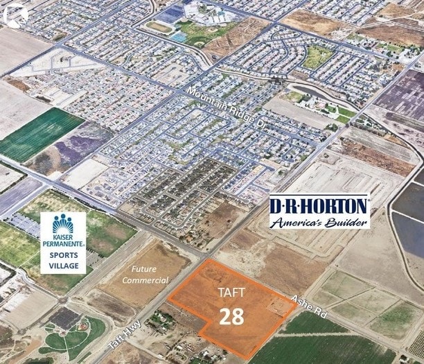


This Property Is For Sale
Property Detail
9737 Ashe Rd
184-260-09-00-4
SECTION 4 , TOWNSHIP 31 , RANGE 27 , QUARTER
Agriculturalland
KERN
R2
California
B and X Area of moderate flood hazard, usually the area between the limits of the 100-year and 500-year floods.
27.97 AC
2024
SW Outlying Kern County
2025
Bakersfield
003220
Bakersfield-Delano, CA
978 SF
NEARBY LISTINGS FOR SALE OR LEASE
DEMOGRAPHICS near 9737 Ashe Rd
1 mile
3 mile
5 mile
2025 Total Population
4,963
56,341
171,149
2030 Population
5,035
57,553
173,565
Pop Growth 2025-2030
+ 1.45%
+ 2.15%
+ 1.41%
Average Age
32
34
35
2025 Total Households
1,269
15,180
50,184
HH Growth 2025-2030
+ 1.50%
+ 2.04%
+ 1.30%
Median Household Inc
$124,083
$100,198
$83,116
Avg Household Size
3.80
3.60
3.30
2025 Avg HH Vehicles
3.00
2.00
2.00
Median Home Value
$423,988
$382,930
$359,622
Median Year Built
2008
2003
1990
Nearby Places
Map Layers
Map Styles
 Street
 Aerial
Layers
 Traffic
 Biking
Places
Listings with unknown addresses are not visible on the map
- Restaurants
- Banks
- Shops
- Fitness
- Groceries
PUBLIC TRANSPORTATION
AIRPORT
Meadows Field
Drive
Walk
Distance
Meadows Field
27 min
16.2 mi
Freight Ports
The Port of Hueneme
Drive
Walk
Distance
The Port of Hueneme
147 min
117.3 mi
Nearby Properties
Address
Land Use
TOTAL SIZE
Lot Size
Zoning
Address
Land Use
TOTAL SIZE
Lot Size
Zoning
269,429 SF
12.71 AC
R-2
Address
Land Use
TOTAL SIZE
Lot Size
Zoning
88,988 SF
9.82 AC
C-2
Address
Land Use
TOTAL SIZE
Lot Size
Zoning
135,549 SF
12 AC
M1
Address
Land Use
TOTAL SIZE
Lot Size
Zoning
149,777 SF
15.27 AC
C2
Address
Land Use
TOTAL SIZE
Lot Size
Zoning
1,014 SF
3.78 AC
PUD
Address
Land Use
TOTAL SIZE
Lot Size
Zoning
80,172 SF
14.14 AC
C-2
Address
Land Use
TOTAL SIZE
Lot Size
Zoning
28,587 SF
3.01 AC
M1
Address
Land Use
TOTAL SIZE
Lot Size
Zoning
50,719 SF
5 AC
C2
Address
Land Use
TOTAL SIZE
Lot Size
Zoning
4,415 SF
5.94 AC
R-1-CH
Address
Land Use
TOTAL SIZE
Lot Size
Zoning
14,736 SF
1.71 AC
C2
Address
Land Use
TOTAL SIZE
Lot Size
Zoning
23,726 SF
2.19 AC
M1
Address
Land Use
TOTAL SIZE
Lot Size
Zoning
3,510 SF
4.66 AC
C2
Address
Land Use
TOTAL SIZE
Lot Size
Zoning
135,860 SF
16.98 AC
Address
Land Use
TOTAL SIZE
Lot Size
Zoning
43.86 AC
Address
Land Use
TOTAL SIZE
Lot Size
Zoning
2,179 SF
14.05 AC
PCD
Address
Land Use
TOTAL SIZE
Lot Size
Zoning
17,316 SF
1.67 AC
C-2
Address
Land Use
TOTAL SIZE
Lot Size
Zoning
36.80 AC
A
Address
Land Use
TOTAL SIZE
Lot Size
Zoning
1.47 AC
Address
Land Use
TOTAL SIZE
Lot Size
Zoning
9,936 SF
2.44 AC
C2 PCD
Address
Land Use
TOTAL SIZE
Lot Size
Zoning
16,632 SF
2.19 AC
C-1
Address
Land Use
TOTAL SIZE
Lot Size
Zoning
2,792 SF
1.03 AC
M1
Address
Land Use
TOTAL SIZE
Lot Size
Zoning
2,472 SF
7.51 AC
C-2
Address
Land Use
TOTAL SIZE
Lot Size
Zoning
2,957 SF
315.45 AC
A
Address
Land Use
TOTAL SIZE
Lot Size
Zoning
17.54 AC
C-2
Address
Land Use
TOTAL SIZE
Lot Size
Zoning
12,479 SF
1.27 AC
C2
Address
Land Use
TOTAL SIZE
Lot Size
Zoning
0.96 AC
The World's #1 Commercial Real Estate Marketplace
Connect with us
© 2026 CoStar Group
The information above has been obtained from sources believed reliable. While we do not doubt its accuracy we have not verified it and make no guarantee, warranty or representation about it. It is your responsibility to independently confirm its accuracy and completeness. Any projections, opinions, assumptions, or estimates used are for example only and do not represent the current or future performance of the property. The value of this transaction to you depends on tax and other factors which should be evaluated by your tax, financial, and legal advisors. You and your advisors should conduct a careful, independent investigation of the property to determine to your satisfaction the suitability of the property for your needs.