Property Record
9737 Se Maricamp Rd, Ocala, FL 34472
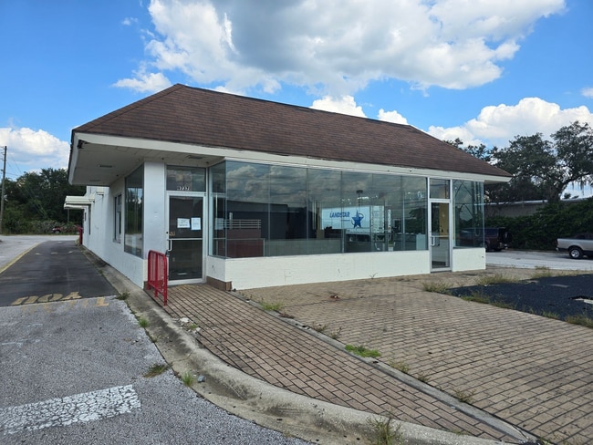
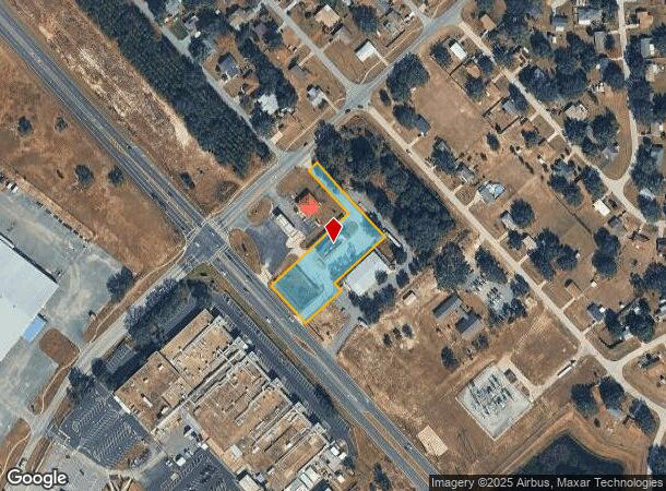
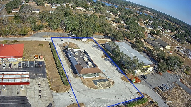
This Property Is For Sale
NEARBY LISTINGS FOR SALE OR LEASE
-
-
View all Ocala listings for sale on LoopNet.com
Property Detail
9737 Se Maricamp Rd
Ocala, FL
Unr Alicia Acres
9028-0864-03
SEC 22 TWP 16 RGE 23 PLAT BOOK J PAGE 434 SILVER SPRINGS SHORES UNT 28 BLK 864 A PORTION OF LOTS 1.2.3.4 BEING MORE PARTICULARLY DESCRIBED AS FOLLOWS: COM SW COR OF LOT 4 BLK 864 THENCE N 42-47-39 W 160 FT ALG E ROW MARICAMP RD (CR 464) THENCE N 47-1
Restaurantdrivein
Marion
X
Florida
12083C0755D
1-4
2024
1.24 AC
2024
Outlying Marion County
001206
Ocala
3,158 SF
DEMOGRAPHICS near 9737 Se Maricamp Rd
1 Mile
3 Mile
5 Mile
2024 Total Population
3,784
21,459
58,343
2029 Population
4,293
24,708
66,544
Pop Growth 2024-2029
+ 13.45%
+ 15.14%
+ 14.06%
Average Age
38
42
43
2024 Total Households
1,368
8,621
23,364
HH Growth 2024-2029
+ 13.38%
+ 15.42%
+ 14.03%
Median Household Inc
$49,647
$47,135
$52,829
Avg Household Size
2.70
2.50
2.50
2024 Avg HH Vehicles
2.00
2.00
2.00
Median Home Value
$122,929
$138,026
$173,336
Median Year Built
1983
1988
1997
Nearby Places
Map Layers
Map Styles
 Street
 Aerial
- Restaurants
- Banks
- Shops
- Fitness
- Groceries
Nearby Properties
Address
Land Use
TOTAL SIZE
Lot Size
Zoning
Address
Land Use
TOTAL SIZE
Lot Size
Zoning
246,762 SF
55.08 AC
PUD
Address
Land Use
TOTAL SIZE
Lot Size
Zoning
188,132 SF
35.86 AC
B4
Address
Land Use
TOTAL SIZE
Lot Size
Zoning
71,791 SF
10.86 AC
B2
Address
Land Use
TOTAL SIZE
Lot Size
Zoning
97,576 SF
23.01 AC
R3
Address
Land Use
TOTAL SIZE
Lot Size
Zoning
11,692 SF
503.98 AC
GU
Address
Land Use
TOTAL SIZE
Lot Size
Zoning
1,800 SF
954.07 AC
A1
Address
Land Use
TOTAL SIZE
Lot Size
Zoning
179,346 SF
13.22 AC
M1
Address
Land Use
TOTAL SIZE
Lot Size
Zoning
78,133 SF
20.10 AC
GU
Address
Land Use
TOTAL SIZE
Lot Size
Zoning
137,302 SF
28.57 AC
M1
Address
Land Use
TOTAL SIZE
Lot Size
Zoning
167,690 SF
19.53 AC
M2
Address
Land Use
TOTAL SIZE
Lot Size
Zoning
69,860 SF
5.05 AC
B2
Address
Land Use
TOTAL SIZE
Lot Size
Zoning
37,862 SF
6.78 AC
R1
Address
Land Use
TOTAL SIZE
Lot Size
Zoning
20,040 SF
2.77 AC
B4
Address
Land Use
TOTAL SIZE
Lot Size
Zoning
130,596 SF
12.49 AC
M2
Address
Land Use
TOTAL SIZE
Lot Size
Zoning
55,219 SF
8.83 AC
B2
Address
Land Use
TOTAL SIZE
Lot Size
Zoning
8,782 SF
4.73 AC
B2
Address
Land Use
TOTAL SIZE
Lot Size
Zoning
52,704 SF
6.88 AC
M1
Address
Land Use
TOTAL SIZE
Lot Size
Zoning
53,142 SF
8.97 AC
M2
Address
Land Use
TOTAL SIZE
Lot Size
Zoning
113,330 SF
19.91 AC
M2
Address
Land Use
TOTAL SIZE
Lot Size
Zoning
198.70 AC
R3
Address
Land Use
TOTAL SIZE
Lot Size
Zoning
23,659 SF
15.47 AC
A1
Address
Land Use
TOTAL SIZE
Lot Size
Zoning
42,220 SF
6.90 AC
B5
Address
Land Use
TOTAL SIZE
Lot Size
Zoning
14,470 SF
2.81 AC
B4
Address
Land Use
TOTAL SIZE
Lot Size
Zoning
66,700 SF
8.97 AC
M2
Address
Land Use
TOTAL SIZE
Lot Size
Zoning
1.54 AC
B2
Address
Land Use
TOTAL SIZE
Lot Size
Zoning
17,120 SF
5.01 AC
B2
Address
Land Use
TOTAL SIZE
Lot Size
Zoning
11,200 SF
2.74 AC
B4
Address
Land Use
TOTAL SIZE
Lot Size
Zoning
65,538 SF
9.28 AC
M2
Address
Land Use
TOTAL SIZE
Lot Size
Zoning
6,783 SF
39.54 AC
PUD
Address
Land Use
TOTAL SIZE
Lot Size
Zoning
15,533 SF
3.65 AC
B2
The World's #1 Commercial Real Estate Marketplace
Connect with us
© 2025 CoStar Group
The information above has been obtained from sources believed reliable. While we do not doubt its accuracy we have not verified it and make no guarantee, warranty or representation about it. It is your responsibility to independently confirm its accuracy and completeness. Any projections, opinions, assumptions, or estimates used are for example only and do not represent the current or future performance of the property. The value of this transaction to you depends on tax and other factors which should be evaluated by your tax, financial, and legal advisors. You and your advisors should conduct a careful, independent investigation of the property to determine to your satisfaction the suitability of the property for your needs.