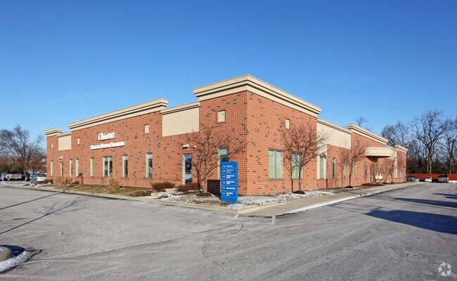
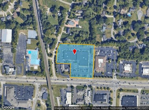
Property Record
974 Bethel Rd, Columbus, OH 43214

NEARBY LISTINGS FOR SALE OR LEASE
Property Detail
974 Bethel Rd
Columbus
United States Military Lands
Columbus, OH
974 BETHEL PIKE R19 T2 1/4T4 3.602 ACRES
010-260509
Franklin
Medicalbuilding
Ohio
2024
12,13
2024
3.60 AC
006950
Bethel Rd
44,809 SF
DEMOGRAPHICS near 974 Bethel Rd
1 Mile
3 Mile
5 Mile
2024 Total Population
14,072
98,711
321,809
2029 Population
14,091
98,227
320,759
Pop Growth 2024-2029
+ 0.14%
(0.49%)
(0.33%)
Average Age
39
41
37
2024 Total Households
7,233
45,262
135,570
HH Growth 2024-2029
+ 0.26%
(0.42%)
(0.32%)
Median Household Inc
$65,456
$81,494
$69,789
Avg Household Size
1.90
2.10
2.30
2024 Avg HH Vehicles
2.00
2.00
2.00
Median Home Value
$279,662
$339,921
$300,410
Median Year Built
1978
1969
1972
Nearby Places
Map Layers
Map Styles
 Street
 Aerial
- Restaurants
- Banks
- Shops
- Fitness
- Groceries
PUBLIC TRANSPORTATION
AIRPORT
John Glenn Columbus International
DRIVE
WALK
Distance
John Glenn Columbus International
23 min
15.4 mi
Rickenbacker International
DRIVE
WALK
Distance
Rickenbacker International
35 min
23.8 mi
SALE & LEASE HISTORY
LISTING DATE
SALE/LEASE

Feb 11, 2022
For Lease
Nearby Properties
Address
Land Use
TOTAL SIZE
Lot Size
Zoning
Address
Land Use
TOTAL SIZE
Lot Size
Zoning
3,462,019 SF
54.42 AC
Address
Land Use
TOTAL SIZE
Lot Size
Zoning
182,845 SF
325.61 AC
Address
Land Use
TOTAL SIZE
Lot Size
Zoning
182,845 SF
325.61 AC
Address
Land Use
TOTAL SIZE
Lot Size
Zoning
240,144 SF
45.78 AC
Address
Land Use
TOTAL SIZE
Lot Size
Zoning
133,425 SF
20.51 AC
Address
Land Use
TOTAL SIZE
Lot Size
Zoning
260,092 SF
29.05 AC
Address
Land Use
TOTAL SIZE
Lot Size
Zoning
344,669 SF
8.45 AC
Address
Land Use
TOTAL SIZE
Lot Size
Zoning
517,875 SF
3.07 AC
Address
Land Use
TOTAL SIZE
Lot Size
Zoning
320,155 SF
84.68 AC
Address
Land Use
TOTAL SIZE
Lot Size
Zoning
234,504 SF
5.40 AC
Address
Land Use
TOTAL SIZE
Lot Size
Zoning
561,921 SF
6.81 AC
Address
Land Use
TOTAL SIZE
Lot Size
Zoning
265,341 SF
19.35 AC
Address
Land Use
TOTAL SIZE
Lot Size
Zoning
286,169 SF
11.08 AC
Address
Land Use
TOTAL SIZE
Lot Size
Zoning
273,578 SF
0.94 AC
Address
Land Use
TOTAL SIZE
Lot Size
Zoning
425,872 SF
10.05 AC
Address
Land Use
TOTAL SIZE
Lot Size
Zoning
115,032 SF
12.81 AC
Address
Land Use
TOTAL SIZE
Lot Size
Zoning
244,602 SF
27.30 AC
Address
Land Use
TOTAL SIZE
Lot Size
Zoning
254,059 SF
6.94 AC
Address
Land Use
TOTAL SIZE
Lot Size
Zoning
257,993 SF
9.98 AC
Address
Land Use
TOTAL SIZE
Lot Size
Zoning
115,392 SF
25 AC
Address
Land Use
TOTAL SIZE
Lot Size
Zoning
273,112 SF
13.97 AC
Address
Land Use
TOTAL SIZE
Lot Size
Zoning
162,408 SF
1.73 AC
Address
Land Use
TOTAL SIZE
Lot Size
Zoning
86,934 SF
8.80 AC
Address
Land Use
TOTAL SIZE
Lot Size
Zoning
147,582 SF
5.75 AC
Address
Land Use
TOTAL SIZE
Lot Size
Zoning
170,237 SF
97.38 AC
Address
Land Use
TOTAL SIZE
Lot Size
Zoning
157,919 SF
13.18 AC
Address
Land Use
TOTAL SIZE
Lot Size
Zoning
150,468 SF
24.57 AC
Address
Land Use
TOTAL SIZE
Lot Size
Zoning
138,100 SF
8.38 AC
Address
Land Use
TOTAL SIZE
Lot Size
Zoning
352,730 SF
17.94 AC
Address
Land Use
TOTAL SIZE
Lot Size
Zoning
187,225 SF
10.28 AC
The World's #1 Commercial Real Estate Marketplace
Connect with us
© 2025 CoStar Group
The information above has been obtained from sources believed reliable. While we do not doubt its accuracy we have not verified it and make no guarantee, warranty or representation about it. It is your responsibility to independently confirm its accuracy and completeness. Any projections, opinions, assumptions, or estimates used are for example only and do not represent the current or future performance of the property. The value of this transaction to you depends on tax and other factors which should be evaluated by your tax, financial, and legal advisors. You and your advisors should conduct a careful, independent investigation of the property to determine to your satisfaction the suitability of the property for your needs.