Property Record
9747 Sierra College Blvd, Granite Bay, CA 95746


NEARBY LISTINGS FOR SALE OR LEASE
-
-
View all Granite Bay listings for sale on LoopNet.com
Property Detail
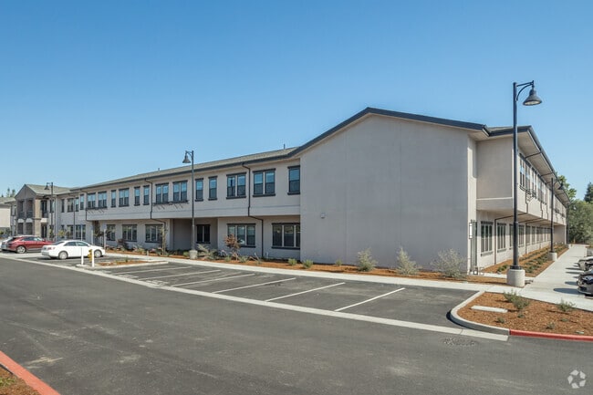
9747 Sierra College Blvd
Sacramento-Roseville-Folsom, CA
PARCEL 1 3.821 AC PMOR BK 36 PG 61
466-030-069
Placer
Retirementnursinghomecombined
California
2024
3.80 AC
2025
Johnson Ranch
020606
Sacramento
118,155 SF
DEMOGRAPHICS near 9747 Sierra College Blvd
1 Mile
3 Mile
5 Mile
2024 Total Population
7,389
83,809
240,896
2029 Population
7,856
86,758
248,326
Pop Growth 2024-2029
+ 6.32%
+ 3.52%
+ 3.08%
Average Age
44
43
42
2024 Total Households
2,501
31,679
91,627
HH Growth 2024-2029
+ 6.36%
+ 3.55%
+ 3.13%
Median Household Inc
$174,305
$100,160
$91,072
Avg Household Size
2.90
2.60
2.50
2024 Avg HH Vehicles
2.00
2.00
2.00
Median Home Value
$811,752
$634,432
$560,709
Median Year Built
1992
1982
1980
Nearby Places
Map Layers
Map Styles
 Street
 Aerial
- Restaurants
- Banks
- Shops
- Fitness
- Groceries
PUBLIC TRANSPORTATION
COMMUTER RAIL
Roseville (California Zephyr - Amtrak, Capitol Corridor - Amtrak)
DRIVE
WALK
Distance
Roseville (California Zephyr - Amtrak, Capitol Corridor - Amtrak)
13 min
5.9 mi
Rocklin Amtrak Station (Capitol Corridor - Amtrak)
DRIVE
WALK
Distance
Rocklin Amtrak Station (Capitol Corridor - Amtrak)
11 min
6.4 mi
AIRPORT
Sacramento International
DRIVE
WALK
Distance
Sacramento International
38 min
26.9 mi
Freight Ports
Port of Stockton
DRIVE
WALK
Distance
Port of Stockton
81 min
67.1 mi
Nearby Properties
Address
Land Use
TOTAL SIZE
Lot Size
Zoning
Address
Land Use
TOTAL SIZE
Lot Size
Zoning
1,444,630 SF
53.20 AC
Address
Land Use
TOTAL SIZE
Lot Size
Zoning
638,040 SF
38.70 AC
Address
Land Use
TOTAL SIZE
Lot Size
Zoning
277,602 SF
26.49 AC
Address
Land Use
TOTAL SIZE
Lot Size
Zoning
223,623 SF
12.70 AC
Address
Land Use
TOTAL SIZE
Lot Size
Zoning
120,983 SF
17.60 AC
Address
Land Use
TOTAL SIZE
Lot Size
Zoning
157,580 SF
16.93 AC
R-M
Address
Land Use
TOTAL SIZE
Lot Size
Zoning
142,063 SF
8.70 AC
Address
Land Use
TOTAL SIZE
Lot Size
Zoning
78,730 SF
8.03 AC
RD20 BP
Address
Land Use
TOTAL SIZE
Lot Size
Zoning
128,480 SF
7.95 AC
RD30 BP
Address
Land Use
TOTAL SIZE
Lot Size
Zoning
119,417 SF
11 AC
Address
Land Use
TOTAL SIZE
Lot Size
Zoning
126,521 SF
11 AC
Address
Land Use
TOTAL SIZE
Lot Size
Zoning
96,522 SF
19.90 AC
FBX
Address
Land Use
TOTAL SIZE
Lot Size
Zoning
10,800 SF
6.70 AC
RAB100
Address
Land Use
TOTAL SIZE
Lot Size
Zoning
109,098 SF
5.50 AC
Address
Land Use
TOTAL SIZE
Lot Size
Zoning
111,418 SF
10.90 AC
Address
Land Use
TOTAL SIZE
Lot Size
Zoning
91,983 SF
3.27 AC
SPA
Address
Land Use
TOTAL SIZE
Lot Size
Zoning
121,155 SF
4.70 AC
C-2 (PD)
Address
Land Use
TOTAL SIZE
Lot Size
Zoning
97,703 SF
9.60 AC
Address
Land Use
TOTAL SIZE
Lot Size
Zoning
162,401 SF
5.29 AC
Address
Land Use
TOTAL SIZE
Lot Size
Zoning
254,982 SF
19.60 AC
Address
Land Use
TOTAL SIZE
Lot Size
Zoning
96,799 SF
7.40 AC
Address
Land Use
TOTAL SIZE
Lot Size
Zoning
82,499 SF
4.74 AC
RD-30
Address
Land Use
TOTAL SIZE
Lot Size
Zoning
61,056 SF
4.50 AC
Address
Land Use
TOTAL SIZE
Lot Size
Zoning
87,942 SF
9.03 AC
SPA
Address
Land Use
TOTAL SIZE
Lot Size
Zoning
117,032 SF
5.90 AC
Address
Land Use
TOTAL SIZE
Lot Size
Zoning
99,963 SF
5.80 AC
Address
Land Use
TOTAL SIZE
Lot Size
Zoning
145,700 SF
9.30 AC
Address
Land Use
TOTAL SIZE
Lot Size
Zoning
134,216 SF
7.79 AC
SPA
Address
Land Use
TOTAL SIZE
Lot Size
Zoning
99,963 SF
7.30 AC
The World's #1 Commercial Real Estate Marketplace
Connect with us
© 2026 CoStar Group
The information above has been obtained from sources believed reliable. While we do not doubt its accuracy we have not verified it and make no guarantee, warranty or representation about it. It is your responsibility to independently confirm its accuracy and completeness. Any projections, opinions, assumptions, or estimates used are for example only and do not represent the current or future performance of the property. The value of this transaction to you depends on tax and other factors which should be evaluated by your tax, financial, and legal advisors. You and your advisors should conduct a careful, independent investigation of the property to determine to your satisfaction the suitability of the property for your needs.