Property Record
975 Broadway St, Wrightstown, WI 54180
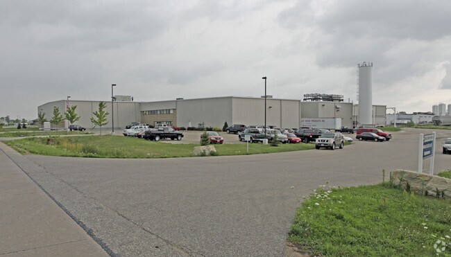

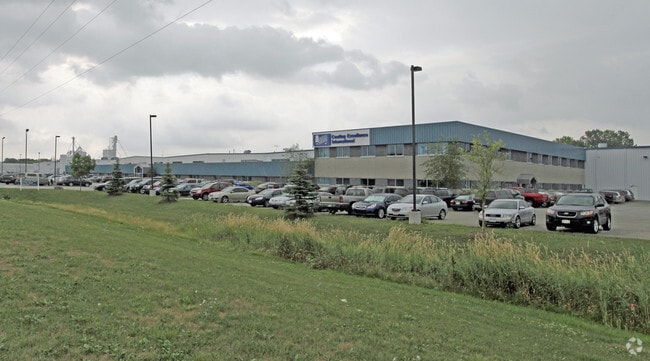
Property Detail
975 Broadway St
Green Bay, WI
24.054 AC M/L LOT 1 OF 52 CSM 210 MAP 7631 IN 2302981 & THAT PRT OF LOT 1 OF 23 CSM 51 MAP 3420 IN 1215227 AS DESC IN 2219761 & THAT PRT OF 49 CSM 143 MAP 7249 IN 2169288 NOT PLATTED IN 52 CSM 210 ALL BNG PRT OF OUTLOT 1 OF ASSESSORS PLAT & REPLAT OF
VW-161-7
BROWN
Industrialgeneral
Wisconsin
B and X Area of moderate flood hazard, usually the area between the limits of the 100-year and 500-year floods.
1
2025
24.05 AC
2025
Ashwaubenon
021400
Green Bay
NEARBY LISTINGS FOR SALE OR LEASE
-
-
View all Wrightstown listings for sale on LoopNet.com
DEMOGRAPHICS near 975 Broadway St
1 mile
3 mile
5 mile
2025 Total Population
1,448
5,094
12,138
2030 Population
1,484
5,214
12,427
Pop Growth 2025-2030
+ 2.49%
+ 2.36%
+ 2.38%
Average Age
38
38
39
2025 Total Households
540
1,898
4,549
HH Growth 2025-2030
+ 2.41%
+ 2.32%
+ 2.29%
Median Household Inc
$100,633
$101,976
$103,581
Avg Household Size
2.70
2.70
2.70
2025 Avg HH Vehicles
2.00
2.00
2.00
Median Home Value
$292,770
$301,713
$321,258
Median Year Built
1994
1994
1992
Nearby Places
Map Layers
Map Styles
 Street
 Aerial
Layers
 Traffic
 Biking
Places
Listings with unknown addresses are not visible on the map
- Restaurants
- Banks
- Shops
- Fitness
- Groceries
PUBLIC TRANSPORTATION
AIRPORT
Green Bay/Austin Straubel International
Drive
Walk
Distance
Green Bay/Austin Straubel International
23 min
15.0 mi
Appleton International
Drive
Walk
Distance
Appleton International
33 min
24.3 mi
Freight Ports
Port Milwaukee
Drive
Walk
Distance
Port Milwaukee
146 min
126.1 mi
Nearby Properties
Address
Land Use
TOTAL SIZE
Lot Size
Zoning
Address
Land Use
TOTAL SIZE
Lot Size
Zoning
Address
Land Use
TOTAL SIZE
Lot Size
Zoning
12.95 AC
Address
Land Use
TOTAL SIZE
Lot Size
Zoning
19.22 AC
Address
Land Use
TOTAL SIZE
Lot Size
Zoning
24.05 AC
Address
Land Use
TOTAL SIZE
Lot Size
Zoning
20.27 AC
Address
Land Use
TOTAL SIZE
Lot Size
Zoning
32.20 AC
Address
Land Use
TOTAL SIZE
Lot Size
Zoning
6.94 AC
Address
Land Use
TOTAL SIZE
Lot Size
Zoning
19.58 AC
Address
Land Use
TOTAL SIZE
Lot Size
Zoning
10.07 AC
Address
Land Use
TOTAL SIZE
Lot Size
Zoning
11.85 AC
Address
Land Use
TOTAL SIZE
Lot Size
Zoning
2.82 AC
Address
Land Use
TOTAL SIZE
Lot Size
Zoning
22.42 AC
Address
Land Use
TOTAL SIZE
Lot Size
Zoning
7.45 AC
Address
Land Use
TOTAL SIZE
Lot Size
Zoning
11.25 AC
Address
Land Use
TOTAL SIZE
Lot Size
Zoning
Address
Land Use
TOTAL SIZE
Lot Size
Zoning
Address
Land Use
TOTAL SIZE
Lot Size
Zoning
38.46 AC
Address
Land Use
TOTAL SIZE
Lot Size
Zoning
7.17 AC
Address
Land Use
TOTAL SIZE
Lot Size
Zoning
9.83 AC
Address
Land Use
TOTAL SIZE
Lot Size
Zoning
11.16 AC
Address
Land Use
TOTAL SIZE
Lot Size
Zoning
13.20 AC
Address
Land Use
TOTAL SIZE
Lot Size
Zoning
Address
Land Use
TOTAL SIZE
Lot Size
Zoning
Address
Land Use
TOTAL SIZE
Lot Size
Zoning
Address
Land Use
TOTAL SIZE
Lot Size
Zoning
Address
Land Use
TOTAL SIZE
Lot Size
Zoning
Address
Land Use
TOTAL SIZE
Lot Size
Zoning
Address
Land Use
TOTAL SIZE
Lot Size
Zoning
Address
Land Use
TOTAL SIZE
Lot Size
Zoning
2.24 AC
Address
Land Use
TOTAL SIZE
Lot Size
Zoning
The World's #1 Commercial Real Estate Marketplace
Connect with us
© 2026 CoStar Group
The information above has been obtained from sources believed reliable. While we do not doubt its accuracy we have not verified it and make no guarantee, warranty or representation about it. It is your responsibility to independently confirm its accuracy and completeness. Any projections, opinions, assumptions, or estimates used are for example only and do not represent the current or future performance of the property. The value of this transaction to you depends on tax and other factors which should be evaluated by your tax, financial, and legal advisors. You and your advisors should conduct a careful, independent investigation of the property to determine to your satisfaction the suitability of the property for your needs.