Property Record
Burnt Tavern Rd, Brick, NJ 08724
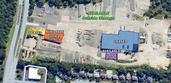
Current Lease Availabilities
NEARBY LISTINGS FOR SALE OR LEASE
Property Detail
Burnt Tavern Rd
Lakewood-New Brunswick, NJ
12.86AC
07-01108-0000-00017
Ocean
Vacantlandnec
New Jersey
X
17
34025C0455F
12.86 AC
2024
Ocean County
2025
Northern New Jersey
713100
DEMOGRAPHICS near Burnt Tavern Rd
1 Mile
3 Mile
5 Mile
2024 Total Population
10,470
74,662
196,623
2029 Population
10,919
77,106
202,627
Pop Growth 2024-2029
+ 4.29%
+ 3.27%
+ 3.05%
Average Age
48
40
38
2024 Total Households
4,588
27,145
66,480
HH Growth 2024-2029
+ 3.44%
+ 2.51%
+ 2.71%
Median Household Inc
$57,117
$90,903
$87,951
Avg Household Size
2.10
2.60
2.70
2024 Avg HH Vehicles
2.00
2.00
2.00
Median Home Value
$307,739
$364,904
$395,347
Median Year Built
1977
1975
1976
Nearby Places
Map Layers
Map Styles
 Street
 Aerial
- Restaurants
- Banks
- Shops
- Fitness
- Groceries
PUBLIC TRANSPORTATION
COMMUTER RAIL
Bay Head (North Jersey Coast Line - NJ Transit Commuter Rail (NJ Transit))
DRIVE
WALK
Distance
Bay Head (North Jersey Coast Line - NJ Transit Commuter Rail (NJ Transit))
11 min
6.2 mi
Point Pleasant Beach (North Jersey Coast Line - NJ Transit Commuter Rail (NJ Transit))
DRIVE
WALK
Distance
Point Pleasant Beach (North Jersey Coast Line - NJ Transit Commuter Rail (NJ Transit))
11 min
7.2 mi
Freight Ports
New York Container Terminal
DRIVE
WALK
Distance
New York Container Terminal
65 min
50.2 mi
Nearby Properties
Address
Land Use
TOTAL SIZE
Lot Size
Zoning
Address
Land Use
TOTAL SIZE
Lot Size
Zoning
45.53 AC
B3
Address
Land Use
TOTAL SIZE
Lot Size
Zoning
22.88 AC
HS
Address
Land Use
TOTAL SIZE
Lot Size
Zoning
2,382 SF
341 AC
OSP
Address
Land Use
TOTAL SIZE
Lot Size
Zoning
21,850 SF
30.98 AC
R-1A
Address
Land Use
TOTAL SIZE
Lot Size
Zoning
29.34 AC
B4
Address
Land Use
TOTAL SIZE
Lot Size
Zoning
25.22 AC
B3
Address
Land Use
TOTAL SIZE
Lot Size
Zoning
49.57 AC
RR1
Address
Land Use
TOTAL SIZE
Lot Size
Zoning
26.37 AC
R75
Address
Land Use
TOTAL SIZE
Lot Size
Zoning
5,826 SF
15.35 AC
RM
Address
Land Use
TOTAL SIZE
Lot Size
Zoning
30 AC
RR1
Address
Land Use
TOTAL SIZE
Lot Size
Zoning
39.84 AC
OPT
Address
Land Use
TOTAL SIZE
Lot Size
Zoning
39,777 SF
3.50 AC
M1
Address
Land Use
TOTAL SIZE
Lot Size
Zoning
26.43 AC
B3
Address
Land Use
TOTAL SIZE
Lot Size
Zoning
162,000 SF
34.35 AC
ARE2
Address
Land Use
TOTAL SIZE
Lot Size
Zoning
2,736 SF
18.04 AC
R15
Address
Land Use
TOTAL SIZE
Lot Size
Zoning
11.83 AC
B3
Address
Land Use
TOTAL SIZE
Lot Size
Zoning
9,429 SF
9.12 AC
B3
Address
Land Use
TOTAL SIZE
Lot Size
Zoning
14.38 AC
B3
Address
Land Use
TOTAL SIZE
Lot Size
Zoning
75,308 SF
3 AC
M1
Address
Land Use
TOTAL SIZE
Lot Size
Zoning
13.82 AC
RM
Address
Land Use
TOTAL SIZE
Lot Size
Zoning
18.39 AC
B3
Address
Land Use
TOTAL SIZE
Lot Size
Zoning
194,670 SF
22 AC
M1
Address
Land Use
TOTAL SIZE
Lot Size
Zoning
15.32 AC
ABC
Address
Land Use
TOTAL SIZE
Lot Size
Zoning
10.84 AC
RM
Address
Land Use
TOTAL SIZE
Lot Size
Zoning
130.72 AC
M1
Address
Land Use
TOTAL SIZE
Lot Size
Zoning
5,121 SF
26.15 AC
B3
Address
Land Use
TOTAL SIZE
Lot Size
Zoning
149,402 SF
9.79 AC
M1
Address
Land Use
TOTAL SIZE
Lot Size
Zoning
145.11 AC
R20
Address
Land Use
TOTAL SIZE
Lot Size
Zoning
7.32 AC
RM
Address
Land Use
TOTAL SIZE
Lot Size
Zoning
61,914 SF
2.91 AC
PS
The World's #1 Commercial Real Estate Marketplace
Connect with us
© 2026 CoStar Group
The information above has been obtained from sources believed reliable. While we do not doubt its accuracy we have not verified it and make no guarantee, warranty or representation about it. It is your responsibility to independently confirm its accuracy and completeness. Any projections, opinions, assumptions, or estimates used are for example only and do not represent the current or future performance of the property. The value of this transaction to you depends on tax and other factors which should be evaluated by your tax, financial, and legal advisors. You and your advisors should conduct a careful, independent investigation of the property to determine to your satisfaction the suitability of the property for your needs.