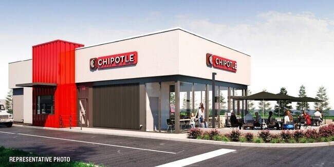
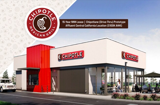
Property Record
975 Sperry Ave, Patterson, CA 95363

Property Detail
975 Sperry Ave
Commercialacreage
STANISLAUS
PC
California
C and X Area of minimal flood hazard, usually depicted on FIRMs as above the 500-year flood level.
0.99 AC
2025
Turlock/SW Stanislaus
2025
Stockton/Modesto
003204
Modesto, CA
2,297 SF
048-47-19
NEARBY LISTINGS FOR SALE OR LEASE
DEMOGRAPHICS near 975 Sperry Ave
1 mile
3 mile
5 mile
2025 Total Population
15,047
27,081
28,036
2030 Population
15,249
27,659
28,586
Pop Growth 2025-2030
+ 1.34%
+ 2.13%
+ 1.96%
Average Age
36
36
36
2025 Total Households
4,112
7,358
7,655
HH Growth 2025-2030
+ 1.36%
+ 2.09%
+ 1.89%
Median Household Inc
$102,225
$103,384
$103,157
Avg Household Size
3.60
3.60
3.60
2025 Avg HH Vehicles
2.00
2.00
2.00
Median Home Value
$471,353
$472,754
$476,576
Median Year Built
1999
2000
2000
Nearby Places
Map Layers
Map Styles
 Street
 Aerial
Layers
 Traffic
 Biking
Places
Listings with unknown addresses are not visible on the map
- Restaurants
- Banks
- Shops
- Fitness
- Groceries
SALE & LEASE HISTORY
LISTING DATE
SALE/LEASE

May 25, 2022
For Sale
Nearby Properties
Address
Land Use
TOTAL SIZE
Lot Size
Zoning
Address
Land Use
TOTAL SIZE
Lot Size
Zoning
1,481,142 SF
93.66 AC
Address
Land Use
TOTAL SIZE
Lot Size
Zoning
800,358 SF
45.99 AC
Address
Land Use
TOTAL SIZE
Lot Size
Zoning
809,971 SF
51.30 AC
0
Address
Land Use
TOTAL SIZE
Lot Size
Zoning
712,101 SF
34.57 AC
PATHI
Address
Land Use
TOTAL SIZE
Lot Size
Zoning
44.79 AC
PATLI
Address
Land Use
TOTAL SIZE
Lot Size
Zoning
1,015,740 SF
33.78 AC
PD
Address
Land Use
TOTAL SIZE
Lot Size
Zoning
396,402 SF
62.64 AC
PATLI
Address
Land Use
TOTAL SIZE
Lot Size
Zoning
21.22 AC
PD
Address
Land Use
TOTAL SIZE
Lot Size
Zoning
529,970 SF
28.41 AC
PATLI
Address
Land Use
TOTAL SIZE
Lot Size
Zoning
23,986 SF
14.29 AC
PATHSC
Address
Land Use
TOTAL SIZE
Lot Size
Zoning
151,117 SF
14.82 AC
PC
Address
Land Use
TOTAL SIZE
Lot Size
Zoning
59.88 AC
Address
Land Use
TOTAL SIZE
Lot Size
Zoning
14,636 SF
11.30 AC
PATLI
Address
Land Use
TOTAL SIZE
Lot Size
Zoning
98,820 SF
5.23 AC
Address
Land Use
TOTAL SIZE
Lot Size
Zoning
36.70 AC
Address
Land Use
TOTAL SIZE
Lot Size
Zoning
50,161 SF
2.95 AC
PD
Address
Land Use
TOTAL SIZE
Lot Size
Zoning
50,889 SF
4.02 AC
Address
Land Use
TOTAL SIZE
Lot Size
Zoning
49,265 SF
2.65 AC
Address
Land Use
TOTAL SIZE
Lot Size
Zoning
43,160 SF
4.29 AC
Address
Land Use
TOTAL SIZE
Lot Size
Zoning
6,851 SF
1.17 AC
PD
Address
Land Use
TOTAL SIZE
Lot Size
Zoning
15,690 SF
2.25 AC
Address
Land Use
TOTAL SIZE
Lot Size
Zoning
3.93 AC
PATMR
Address
Land Use
TOTAL SIZE
Lot Size
Zoning
1.99 AC
PATHSC
Address
Land Use
TOTAL SIZE
Lot Size
Zoning
3,252 SF
215 AC
Address
Land Use
TOTAL SIZE
Lot Size
Zoning
56.50 AC
PATLI
Address
Land Use
TOTAL SIZE
Lot Size
Zoning
3.14 AC
PATMR
Address
Land Use
TOTAL SIZE
Lot Size
Zoning
74 AC
PATLI
Address
Land Use
TOTAL SIZE
Lot Size
Zoning
28,672 SF
2.67 AC
Address
Land Use
TOTAL SIZE
Lot Size
Zoning
14,820 SF
1.38 AC
PATGC
Address
Land Use
TOTAL SIZE
Lot Size
Zoning
26.53 AC
PATLI
The World's #1 Commercial Real Estate Marketplace
Connect with us
© 2026 CoStar Group
The information above has been obtained from sources believed reliable. While we do not doubt its accuracy we have not verified it and make no guarantee, warranty or representation about it. It is your responsibility to independently confirm its accuracy and completeness. Any projections, opinions, assumptions, or estimates used are for example only and do not represent the current or future performance of the property. The value of this transaction to you depends on tax and other factors which should be evaluated by your tax, financial, and legal advisors. You and your advisors should conduct a careful, independent investigation of the property to determine to your satisfaction the suitability of the property for your needs.