Property Record
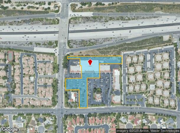
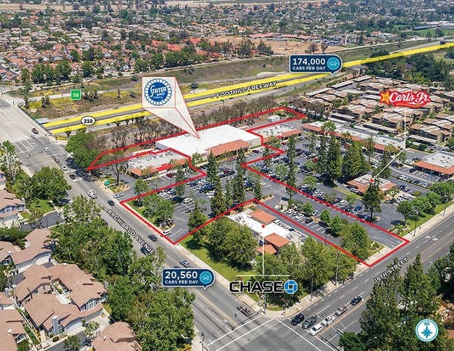
9750 19Th St, Rancho Cucamonga, CA 91737


NEARBY LISTINGS FOR SALE OR LEASE
Property Detail
9750 19Th St
1076-011-09
City Of Rancho Cucamonga
Supermarket
PARCEL MAP 3872 PARCEL 6
X
San Bernardino
06071C7890J
California
2024
2.76 AC
2025
Airport Area
002023
Inland Empire (California)
24,400 SF
Riverside-San Bernardino-Ontario, CA
DEMOGRAPHICS near 9750 19Th St
1 Mile
3 Mile
5 Mile
2024 Total Population
20,058
131,144
280,638
2029 Population
20,330
132,938
284,772
Pop Growth 2024-2029
+ 1.36%
+ 1.37%
+ 1.47%
Average Age
42
40
39
2024 Total Households
7,513
45,789
93,208
HH Growth 2024-2029
+ 1.34%
+ 1.38%
+ 1.53%
Median Household Inc
$84,165
$99,383
$96,372
Avg Household Size
2.60
2.80
2.90
2024 Avg HH Vehicles
2.00
2.00
2.00
Median Home Value
$655,349
$660,899
$660,315
Median Year Built
1980
1983
1983
Nearby Places
Map Layers
Map Styles
 Street
 Aerial
- Restaurants
- Banks
- Shops
- Fitness
- Groceries
PUBLIC TRANSPORTATION
COMMUTER RAIL
Rancho Cucamonga (San Bernardino Line - Southern California Regional Rail Authority (Metrolink))
DRIVE
WALK
Distance
Rancho Cucamonga (San Bernardino Line - Southern California Regional Rail Authority (Metrolink))
10 min
5.6 mi
Upland (San Bernardino Line - Southern California Regional Rail Authority (Metrolink))
DRIVE
WALK
Distance
Upland (San Bernardino Line - Southern California Regional Rail Authority (Metrolink))
12 min
6.0 mi
AIRPORT
Ontario International
DRIVE
WALK
Distance
Ontario International
12 min
5.8 mi
John Wayne/Orange County
DRIVE
WALK
Distance
John Wayne/Orange County
59 min
48.6 mi
SALE & LEASE HISTORY
LISTING DATE
SALE/LEASE

May 22, 2017
For Sale
Dec 20, 2017
For Sale
Nearby Properties
Address
Land Use
TOTAL SIZE
Lot Size
Zoning
Address
Land Use
TOTAL SIZE
Lot Size
Zoning
293,860 SF
16.10 AC
Address
Land Use
TOTAL SIZE
Lot Size
Zoning
190,724 SF
10.69 AC
Address
Land Use
TOTAL SIZE
Lot Size
Zoning
174,092 SF
4.42 AC
Address
Land Use
TOTAL SIZE
Lot Size
Zoning
251,645 SF
4.50 AC
Address
Land Use
TOTAL SIZE
Lot Size
Zoning
340,104 SF
8.95 AC
Address
Land Use
TOTAL SIZE
Lot Size
Zoning
249,672 SF
13.80 AC
Address
Land Use
TOTAL SIZE
Lot Size
Zoning
139,059 SF
20.83 AC
Address
Land Use
TOTAL SIZE
Lot Size
Zoning
122,563 SF
5.76 AC
Address
Land Use
TOTAL SIZE
Lot Size
Zoning
225,727 SF
7.18 AC
Address
Land Use
TOTAL SIZE
Lot Size
Zoning
354,616 SF
20.07 AC
Address
Land Use
TOTAL SIZE
Lot Size
Zoning
324,131 SF
19.81 AC
Address
Land Use
TOTAL SIZE
Lot Size
Zoning
161,555 SF
8.25 AC
Address
Land Use
TOTAL SIZE
Lot Size
Zoning
95,240 SF
8.42 AC
Address
Land Use
TOTAL SIZE
Lot Size
Zoning
99,345 SF
5.15 AC
Address
Land Use
TOTAL SIZE
Lot Size
Zoning
63,862 SF
4.77 AC
Address
Land Use
TOTAL SIZE
Lot Size
Zoning
171,446 SF
10.88 AC
Address
Land Use
TOTAL SIZE
Lot Size
Zoning
133,847 SF
7.52 AC
Address
Land Use
TOTAL SIZE
Lot Size
Zoning
79,319 SF
4.47 AC
Address
Land Use
TOTAL SIZE
Lot Size
Zoning
54,166 SF
4.60 AC
Address
Land Use
TOTAL SIZE
Lot Size
Zoning
54,444 SF
4.71 AC
Address
Land Use
TOTAL SIZE
Lot Size
Zoning
175,624 SF
8.20 AC
Address
Land Use
TOTAL SIZE
Lot Size
Zoning
101,796 SF
8.82 AC
Address
Land Use
TOTAL SIZE
Lot Size
Zoning
87,386 SF
3.90 AC
Address
Land Use
TOTAL SIZE
Lot Size
Zoning
221,632 SF
14.56 AC
Address
Land Use
TOTAL SIZE
Lot Size
Zoning
108,000 SF
8.78 AC
Address
Land Use
TOTAL SIZE
Lot Size
Zoning
187,841 SF
6.14 AC
Address
Land Use
TOTAL SIZE
Lot Size
Zoning
54,366 SF
4.95 AC
Address
Land Use
TOTAL SIZE
Lot Size
Zoning
139,921 SF
8.72 AC
Address
Land Use
TOTAL SIZE
Lot Size
Zoning
97,759 SF
6.23 AC
Address
Land Use
TOTAL SIZE
Lot Size
Zoning
145,880 SF
9.76 AC
The World's #1 Commercial Real Estate Marketplace
Connect with us
© 2025 CoStar Group
The information above has been obtained from sources believed reliable. While we do not doubt its accuracy we have not verified it and make no guarantee, warranty or representation about it. It is your responsibility to independently confirm its accuracy and completeness. Any projections, opinions, assumptions, or estimates used are for example only and do not represent the current or future performance of the property. The value of this transaction to you depends on tax and other factors which should be evaluated by your tax, financial, and legal advisors. You and your advisors should conduct a careful, independent investigation of the property to determine to your satisfaction the suitability of the property for your needs.