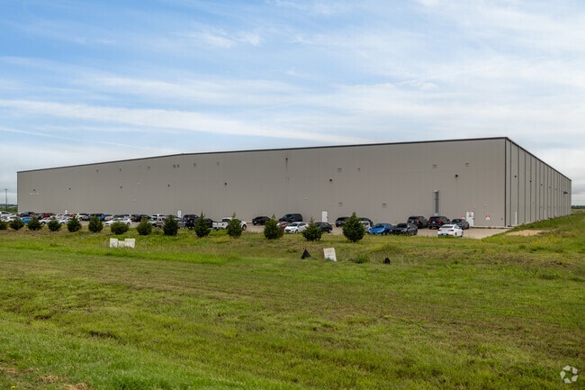
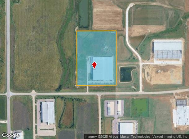
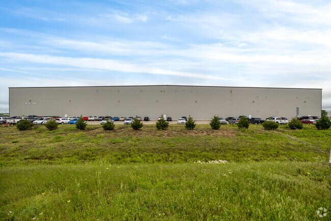
Property Record
9750 E 53Rd St N, Bel Aire, KS 67226
NEARBY LISTINGS FOR SALE OR LEASE
Property Detail
9750 E 53Rd St N
Wichita, KS
Sunflower Commerce Park 2Nd Add
105-16-0-34-01-001.00
LOT 1 BLOCK A SUNFLOWER COMMERCE PARK 2ND ADDITION
Warehouse
Sedgwick
X
Kansas
20173C0240G
1
2024
19.75 AC
2025
Park City/North
010116
Wichita
184,788 SF
DEMOGRAPHICS near 9750 E 53Rd St N
1 Mile
3 Mile
5 Mile
2024 Total Population
507
11,660
45,610
2029 Population
509
11,795
46,127
Pop Growth 2024-2029
+ 0.39%
+ 1.16%
+ 1.13%
Average Age
38
39
39
2024 Total Households
183
4,573
18,522
HH Growth 2024-2029
+ 0.55%
+ 1.09%
+ 1.03%
Median Household Inc
$104,808
$84,924
$78,853
Avg Household Size
2.70
2.50
2.40
2024 Avg HH Vehicles
2.00
2.00
2.00
Median Home Value
$290,697
$253,115
$237,235
Median Year Built
2003
1998
1993
Nearby Places
Map Layers
Map Styles
 Street
 Aerial
- Restaurants
- Banks
- Shops
- Fitness
- Groceries
PUBLIC TRANSPORTATION
AIRPORT
Wichita Dwight D Eisenhower Ntl
DRIVE
WALK
Distance
Wichita Dwight D Eisenhower Ntl
28 min
19.5 mi
Freight Ports
Tulsa Port Of Catoosa
DRIVE
WALK
Distance
Tulsa Port Of Catoosa
218 min
201.8 mi
Nearby Properties
Address
Land Use
TOTAL SIZE
Lot Size
Zoning
Address
Land Use
TOTAL SIZE
Lot Size
Zoning
256,570 SF
53.92 AC
R3
Address
Land Use
TOTAL SIZE
Lot Size
Zoning
243,768 SF
5.42 AC
LI
Address
Land Use
TOTAL SIZE
Lot Size
Zoning
366,272 SF
332.54 AC
LI
Address
Land Use
TOTAL SIZE
Lot Size
Zoning
129,965 SF
41.88 AC
R3
Address
Land Use
TOTAL SIZE
Lot Size
Zoning
79,739 SF
10.11 AC
R6
Address
Land Use
TOTAL SIZE
Lot Size
Zoning
69,125 SF
16.79 AC
MF-29,MF-1
Address
Land Use
TOTAL SIZE
Lot Size
Zoning
102,200 SF
8.77 AC
R6
Address
Land Use
TOTAL SIZE
Lot Size
Zoning
74,265 SF
15.01 AC
LC
Address
Land Use
TOTAL SIZE
Lot Size
Zoning
40,267 SF
10.55 AC
R6
Address
Land Use
TOTAL SIZE
Lot Size
Zoning
60,868 SF
4.17 AC
LI
Address
Land Use
TOTAL SIZE
Lot Size
Zoning
72,002 SF
11.81 AC
LC
Address
Land Use
TOTAL SIZE
Lot Size
Zoning
76,382 SF
8.77 AC
R4
Address
Land Use
TOTAL SIZE
Lot Size
Zoning
52,156 SF
5.89 AC
R6
Address
Land Use
TOTAL SIZE
Lot Size
Zoning
91,702 SF
53.96 AC
I-1
Address
Land Use
TOTAL SIZE
Lot Size
Zoning
107,956 SF
3.38 AC
M1
Address
Land Use
TOTAL SIZE
Lot Size
Zoning
33,505 SF
4.75 AC
R6
Address
Land Use
TOTAL SIZE
Lot Size
Zoning
71,829 SF
4.41 AC
LI
Address
Land Use
TOTAL SIZE
Lot Size
Zoning
20,014 SF
8.17 AC
R3
Address
Land Use
TOTAL SIZE
Lot Size
Zoning
73,670 SF
10.96 AC
MF-29
Address
Land Use
TOTAL SIZE
Lot Size
Zoning
61,502 SF
2.78 AC
LI
Address
Land Use
TOTAL SIZE
Lot Size
Zoning
30,500 SF
1.68 AC
LI
Address
Land Use
TOTAL SIZE
Lot Size
Zoning
333,897 SF
41.56 AC
LI
Address
Land Use
TOTAL SIZE
Lot Size
Zoning
20,969 SF
8.85 AC
I-1
Address
Land Use
TOTAL SIZE
Lot Size
Zoning
184,034 SF
16.71 AC
PUD
Address
Land Use
TOTAL SIZE
Lot Size
Zoning
30,914 SF
11.47 AC
M-1
Address
Land Use
TOTAL SIZE
Lot Size
Zoning
75 SF
2.28 AC
PUD
Address
Land Use
TOTAL SIZE
Lot Size
Zoning
181,480 SF
12.34 AC
M1
Address
Land Use
TOTAL SIZE
Lot Size
Zoning
66,272 SF
16.31 AC
MF-29
The World's #1 Commercial Real Estate Marketplace
Connect with us
© 2025 CoStar Group
The information above has been obtained from sources believed reliable. While we do not doubt its accuracy we have not verified it and make no guarantee, warranty or representation about it. It is your responsibility to independently confirm its accuracy and completeness. Any projections, opinions, assumptions, or estimates used are for example only and do not represent the current or future performance of the property. The value of this transaction to you depends on tax and other factors which should be evaluated by your tax, financial, and legal advisors. You and your advisors should conduct a careful, independent investigation of the property to determine to your satisfaction the suitability of the property for your needs.