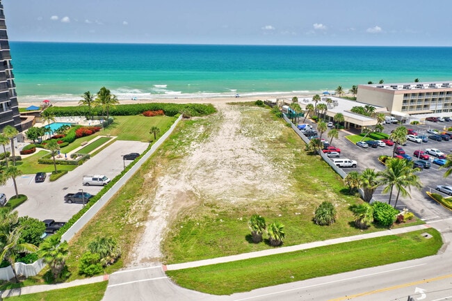
Property Record
9750 S Ocean Dr, Fort Pierce, FL 34949
NEARBY LISTINGS FOR SALE OR LEASE
Property Detail
9750 S Ocean Dr
Port St Lucie, FL
Metes And Bounds
45-02-241-0002-0008
2 37 41 THE WEST 200` OF THE FOLLOWING DESC PROP: BEG AT PT ON W LI OF GOVT LOT 3, SD PT BEING 1785.84 FT S OF N LI OF SEC, TH RUN S 89 DEG 38 MIN 22 SEC E 740 FT M/L TO W R/W A1A,TH S 21 DEG 13 MIN 52 SEC E ALG W R/W 132 FT M/L,THS 75 DEG 02 MIN 37
Residentialacreage
St Lucie
AE
Florida
12111C0312K
3
2024
1.29 AC
2025
St Lucie Coastal
381702
Port St Lucie/Fort Pierce
DEMOGRAPHICS near 9750 S Ocean Dr
1 Mile
3 Mile
5 Mile
2024 Total Population
7,543
15,034
52,119
2029 Population
9,728
18,785
61,351
Pop Growth 2024-2029
+ 28.97%
+ 24.95%
+ 17.71%
Average Age
68
64
52
2024 Total Households
4,244
8,207
24,548
HH Growth 2024-2029
+ 28.58%
+ 25.06%
+ 17.92%
Median Household Inc
$60,930
$63,838
$60,519
Avg Household Size
1.70
1.80
2.10
2024 Avg HH Vehicles
1.00
1.00
2.00
Median Home Value
$377,313
$369,618
$305,775
Median Year Built
1987
1986
1988
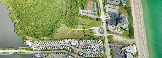
Nearby Places
Map Layers
Map Styles
 Street
 Aerial
- Restaurants
- Banks
- Shops
- Fitness
- Groceries
SALE & LEASE HISTORY
LISTING DATE
SALE/LEASE

Nov 23, 2022
For Sale
Nov 06, 2018
For Sale
Nearby Properties
Address
Land Use
TOTAL SIZE
Lot Size
Zoning
Address
Land Use
TOTAL SIZE
Lot Size
Zoning
152,866 SF
3.24 AC
HB1AA
Address
Land Use
TOTAL SIZE
Lot Size
Zoning
10,005 SF
2.69 AC
HUTCH ISLA
Address
Land Use
TOTAL SIZE
Lot Size
Zoning
216 SF
143.66 AC
CONSERVATI
Address
Land Use
TOTAL SIZE
Lot Size
Zoning
8,464 SF
24.79 AC
UTILITIES
Address
Land Use
TOTAL SIZE
Lot Size
Zoning
7.51 AC
HUTCH ISLA
Address
Land Use
TOTAL SIZE
Lot Size
Zoning
5.82 AC
HUTCH ISLA
Address
Land Use
TOTAL SIZE
Lot Size
Zoning
32,913 SF
6 AC
HB1
Address
Land Use
TOTAL SIZE
Lot Size
Zoning
20,290 SF
1.93 AC
COMM NEIGH
Address
Land Use
TOTAL SIZE
Lot Size
Zoning
51.51 AC
Address
Land Use
TOTAL SIZE
Lot Size
Zoning
3.45 AC
R3
Address
Land Use
TOTAL SIZE
Lot Size
Zoning
18,479 SF
1.60 AC
COMM GENRA
Address
Land Use
TOTAL SIZE
Lot Size
Zoning
750 SF
5.95 AC
R3A
Address
Land Use
TOTAL SIZE
Lot Size
Zoning
Address
Land Use
TOTAL SIZE
Lot Size
Zoning
9,200 SF
1.14 AC
COMM GENRA
Address
Land Use
TOTAL SIZE
Lot Size
Zoning
3.66 AC
R3A
Address
Land Use
TOTAL SIZE
Lot Size
Zoning
15,494 SF
0.24 AC
R3A
Address
Land Use
TOTAL SIZE
Lot Size
Zoning
9,718 SF
1.53 AC
HUTCH ISLA
Address
Land Use
TOTAL SIZE
Lot Size
Zoning
199,505 SF
4.58 AC
COR2
Address
Land Use
TOTAL SIZE
Lot Size
Zoning
8.91 AC
HUTCH ISLA
Address
Land Use
TOTAL SIZE
Lot Size
Zoning
3,286 SF
70.42 AC
PUD
Address
Land Use
TOTAL SIZE
Lot Size
Zoning
8,978 SF
4.92 AC
RM-5 - COU
Address
Land Use
TOTAL SIZE
Lot Size
Zoning
1.01 AC
HUTCH ISLA
Address
Land Use
TOTAL SIZE
Lot Size
Zoning
15.73 AC
PUD
Address
Land Use
TOTAL SIZE
Lot Size
Zoning
462 SF
3.33 AC
INSTITUTIO
Address
Land Use
TOTAL SIZE
Lot Size
Zoning
5,951 SF
0.73 AC
LC
Address
Land Use
TOTAL SIZE
Lot Size
Zoning
1.13 AC
HUTCH ISLA
Address
Land Use
TOTAL SIZE
Lot Size
Zoning
0.68 AC
HUTCH ISLA
Address
Land Use
TOTAL SIZE
Lot Size
Zoning
17,661 SF
6.90 AC
R2
Address
Land Use
TOTAL SIZE
Lot Size
Zoning
0.71 AC
HUTCH ISLA
The World's #1 Commercial Real Estate Marketplace
Connect with us
© 2025 CoStar Group
The information above has been obtained from sources believed reliable. While we do not doubt its accuracy we have not verified it and make no guarantee, warranty or representation about it. It is your responsibility to independently confirm its accuracy and completeness. Any projections, opinions, assumptions, or estimates used are for example only and do not represent the current or future performance of the property. The value of this transaction to you depends on tax and other factors which should be evaluated by your tax, financial, and legal advisors. You and your advisors should conduct a careful, independent investigation of the property to determine to your satisfaction the suitability of the property for your needs.