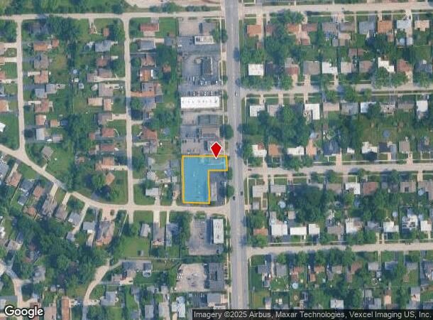
Property Record
9750 S Roberts Rd, Palos Hills, IL 60465
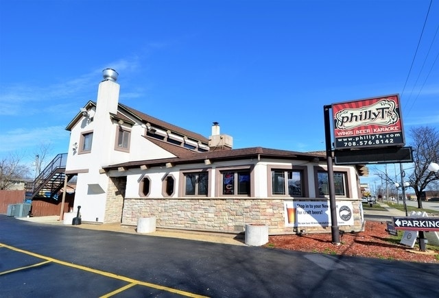
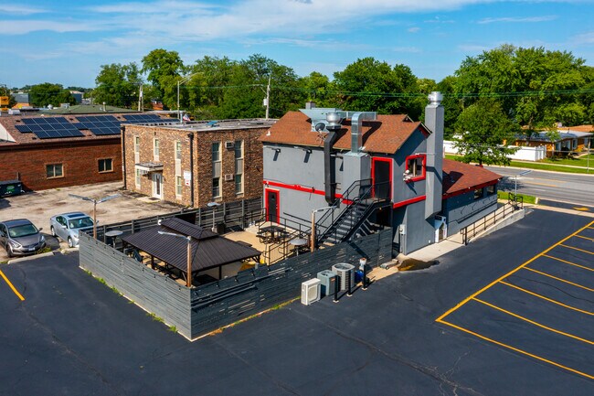

This Property Is For Sale
NEARBY LISTINGS FOR SALE OR LEASE
Property Detail
9750 S Roberts Rd
Chicago-Naperville-Elgin, IL-IN-WI
Philly Ts Resubd
23-11-205-025-0000
L1 PHILLY TS RESUBD E1/2 NE1/4 S11 T37N R12E
Storebuilding
Cook
X
Illinois
17031C0604J
1
2023
0.56 AC
2024
South Route 45
823702
Chicago
2,476 SF
DEMOGRAPHICS near 9750 S Roberts Rd
1 Mile
3 Mile
5 Mile
2024 Total Population
14,616
112,342
242,616
2029 Population
14,188
109,179
235,507
Pop Growth 2024-2029
(2.93%)
(2.82%)
(2.93%)
Average Age
40
40
41
2024 Total Households
5,443
41,511
89,974
HH Growth 2024-2029
(3.27%)
(3.11%)
(3.22%)
Median Household Inc
$69,279
$62,575
$70,500
Avg Household Size
2.60
2.60
2.60
2024 Avg HH Vehicles
2.00
2.00
2.00
Median Home Value
$275,324
$235,697
$246,919
Median Year Built
1975
1973
1970
Nearby Places
- Restaurants
- Banks
- Shops
- Fitness
- Groceries
PUBLIC TRANSPORTATION
COMMUTER RAIL
Worth Station (SouthWest Service - Northeast Illinois Regional Commuter Railroad (Metra))
DRIVE
WALK
Distance
Worth Station (SouthWest Service - Northeast Illinois Regional Commuter Railroad (Metra))
7 min
2.9 mi
Chicago Ridge Station (SouthWest Service - Northeast Illinois Regional Commuter Railroad (Metra))
DRIVE
WALK
Distance
Chicago Ridge Station (SouthWest Service - Northeast Illinois Regional Commuter Railroad (Metra))
7 min
3.6 mi
AIRPORT
Chicago Midway International
DRIVE
WALK
Distance
Chicago Midway International
17 min
9.5 mi
Chicago O'Hare International
DRIVE
WALK
Distance
Chicago O'Hare International
38 min
27.3 mi
Freight Ports
Port Milwaukee
DRIVE
WALK
Distance
Port Milwaukee
119 min
99.1 mi
Nearby Properties
Address
Land Use
TOTAL SIZE
Lot Size
Zoning
Address
Land Use
TOTAL SIZE
Lot Size
Zoning
Address
Land Use
TOTAL SIZE
Lot Size
Zoning
252,973 SF
11.68 AC
Address
Land Use
TOTAL SIZE
Lot Size
Zoning
51,762 SF
4 AC
Address
Land Use
TOTAL SIZE
Lot Size
Zoning
191,763 SF
15.63 AC
Address
Land Use
TOTAL SIZE
Lot Size
Zoning
111,830 SF
2.16 AC
Address
Land Use
TOTAL SIZE
Lot Size
Zoning
198,190 SF
15 AC
Address
Land Use
TOTAL SIZE
Lot Size
Zoning
16,077 SF
66.23 AC
Address
Land Use
TOTAL SIZE
Lot Size
Zoning
96,469 SF
6.77 AC
Address
Land Use
TOTAL SIZE
Lot Size
Zoning
28,406 SF
1.42 AC
Address
Land Use
TOTAL SIZE
Lot Size
Zoning
61,388 SF
2 AC
Address
Land Use
TOTAL SIZE
Lot Size
Zoning
Address
Land Use
TOTAL SIZE
Lot Size
Zoning
45,196 SF
1.28 AC
Address
Land Use
TOTAL SIZE
Lot Size
Zoning
127,984 SF
12.76 AC
Address
Land Use
TOTAL SIZE
Lot Size
Zoning
350,200 SF
Address
Land Use
TOTAL SIZE
Lot Size
Zoning
43,271 SF
2.09 AC
Address
Land Use
TOTAL SIZE
Lot Size
Zoning
115,850 SF
10.08 AC
Address
Land Use
TOTAL SIZE
Lot Size
Zoning
132,579 SF
9.11 AC
Address
Land Use
TOTAL SIZE
Lot Size
Zoning
Address
Land Use
TOTAL SIZE
Lot Size
Zoning
50,151 SF
2.85 AC
Address
Land Use
TOTAL SIZE
Lot Size
Zoning
186,152 SF
13.85 AC
Address
Land Use
TOTAL SIZE
Lot Size
Zoning
169,100 SF
4.43 AC
Address
Land Use
TOTAL SIZE
Lot Size
Zoning
9,125 SF
6 AC
Address
Land Use
TOTAL SIZE
Lot Size
Zoning
64,494 SF
4.52 AC
Address
Land Use
TOTAL SIZE
Lot Size
Zoning
210,651 SF
15.30 AC
Address
Land Use
TOTAL SIZE
Lot Size
Zoning
122,619 SF
18.30 AC
Address
Land Use
TOTAL SIZE
Lot Size
Zoning
390,636 SF
9.50 AC
Address
Land Use
TOTAL SIZE
Lot Size
Zoning
76,891 SF
4.69 AC
Address
Land Use
TOTAL SIZE
Lot Size
Zoning
72,037 SF
7.07 AC
Address
Land Use
TOTAL SIZE
Lot Size
Zoning
13.61 AC
Address
Land Use
TOTAL SIZE
Lot Size
Zoning
64,233 SF
1.47 AC
The World's #1 Commercial Real Estate Marketplace
Connect with us
© 2025 CoStar Group
The information above has been obtained from sources believed reliable. While we do not doubt its accuracy we have not verified it and make no guarantee, warranty or representation about it. It is your responsibility to independently confirm its accuracy and completeness. Any projections, opinions, assumptions, or estimates used are for example only and do not represent the current or future performance of the property. The value of this transaction to you depends on tax and other factors which should be evaluated by your tax, financial, and legal advisors. You and your advisors should conduct a careful, independent investigation of the property to determine to your satisfaction the suitability of the property for your needs.