Property Record
9750 Se Mount Scott Blvd, Portland, OR 97266
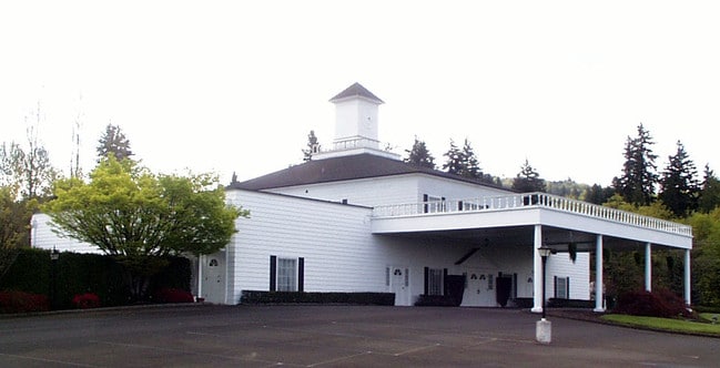

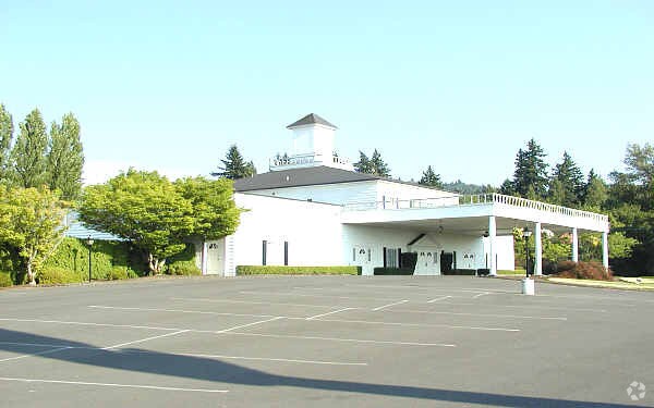

Property Detail
9750 Se Mount Scott Blvd
R336682
SECTION 21 1S 2E, TL 100 3.01 ACRES
Commercialnec
MULTNOMAH
CE
Oregon
B and X Area of moderate flood hazard, usually the area between the limits of the 100-year and 500-year floods.
3.01 AC
0
Clackamas/Milwaukie
2025
Portland
008902
Portland-Vancouver-Hillsboro, OR-WA
13,059 SF
NEARBY LISTINGS FOR SALE OR LEASE
DEMOGRAPHICS near 9750 Se Mount Scott Blvd
1 mile
3 mile
5 mile
2025 Total Population
15,338
150,668
398,759
2030 Population
15,136
149,377
395,667
Pop Growth 2025-2030
(1.32%)
(0.86%)
(0.78%)
Average Age
40
40
41
2025 Total Households
5,637
55,637
154,429
HH Growth 2025-2030
(1.58%)
(1.09%)
(1.02%)
Median Household Inc
$88,042
$85,999
$85,296
Avg Household Size
2.50
2.60
2.50
2025 Avg HH Vehicles
2.00
2.00
2.00
Median Home Value
$479,391
$484,053
$527,208
Median Year Built
1978
1974
1971
Nearby Places
Map Layers
Map Styles
 Street
 Aerial
Transit
 Traffic
 Biking
Places
Listings with unknown addresses are not visible on the map
- Restaurants
- Banks
- Shops
- Fitness
- Groceries
PUBLIC TRANSPORTATION
COMMUTER RAIL
Drive
Walk
Distance
15 min
8.7 mi
AIRPORT
Portland International
Drive
Walk
Distance
Portland International
20 min
10.8 mi
Freight Ports
Port of Portland
Drive
Walk
Distance
Port of Portland
24 min
14.2 mi
Nearby Properties
Address
Land Use
TOTAL SIZE
Lot Size
Zoning
Address
Land Use
TOTAL SIZE
Lot Size
Zoning
22 AC
PMU1
Address
Land Use
TOTAL SIZE
Lot Size
Zoning
1,024 SF
15.92 AC
OS
Address
Land Use
TOTAL SIZE
Lot Size
Zoning
28.83 AC
RCO
Address
Land Use
TOTAL SIZE
Lot Size
Zoning
Address
Land Use
TOTAL SIZE
Lot Size
Zoning
Address
Land Use
TOTAL SIZE
Lot Size
Zoning
250,280 SF
23.86 AC
IR
Address
Land Use
TOTAL SIZE
Lot Size
Zoning
31,878 SF
15.95 AC
IG2
Address
Land Use
TOTAL SIZE
Lot Size
Zoning
828 SF
23.69 AC
MR2
Address
Land Use
TOTAL SIZE
Lot Size
Zoning
100,217 SF
1.99 AC
R5
Address
Land Use
TOTAL SIZE
Lot Size
Zoning
181,493 SF
3.70 AC
CM1
Address
Land Use
TOTAL SIZE
Lot Size
Zoning
15.05 AC
CC
Address
Land Use
TOTAL SIZE
Lot Size
Zoning
2,183 SF
6 AC
RCHDR
Address
Land Use
TOTAL SIZE
Lot Size
Zoning
2,108 SF
12.08 AC
HDR
Address
Land Use
TOTAL SIZE
Lot Size
Zoning
11 AC
RCHDR
Address
Land Use
TOTAL SIZE
Lot Size
Zoning
Address
Land Use
TOTAL SIZE
Lot Size
Zoning
24 AC
LI
Address
Land Use
TOTAL SIZE
Lot Size
Zoning
57,300 SF
4.38 AC
R5
Address
Land Use
TOTAL SIZE
Lot Size
Zoning
20 AC
RTL
Address
Land Use
TOTAL SIZE
Lot Size
Zoning
500 SF
9 AC
RCHDR
Address
Land Use
TOTAL SIZE
Lot Size
Zoning
21,200 SF
16.03 AC
OS
Address
Land Use
TOTAL SIZE
Lot Size
Zoning
64,658 SF
7.79 AC
R5
Address
Land Use
TOTAL SIZE
Lot Size
Zoning
1,032 SF
5.50 AC
MR2
Address
Land Use
TOTAL SIZE
Lot Size
Zoning
105,961 SF
8.76 AC
RM1
Address
Land Use
TOTAL SIZE
Lot Size
Zoning
5.24 AC
SCMU
Address
Land Use
TOTAL SIZE
Lot Size
Zoning
143,116 SF
0.92 AC
CM2
Address
Land Use
TOTAL SIZE
Lot Size
Zoning
3.10 AC
RCO
Address
Land Use
TOTAL SIZE
Lot Size
Zoning
4 AC
RCHDR
Address
Land Use
TOTAL SIZE
Lot Size
Zoning
5.69 AC
IG2
Address
Land Use
TOTAL SIZE
Lot Size
Zoning
122,558 SF
9.85 AC
CM2
Address
Land Use
TOTAL SIZE
Lot Size
Zoning
68,533 SF
4.18 AC
OS
The World's #1 Commercial Real Estate Marketplace
Connect with us
© 2026 CoStar Group
The information above has been obtained from sources believed reliable. While we do not doubt its accuracy we have not verified it and make no guarantee, warranty or representation about it. It is your responsibility to independently confirm its accuracy and completeness. Any projections, opinions, assumptions, or estimates used are for example only and do not represent the current or future performance of the property. The value of this transaction to you depends on tax and other factors which should be evaluated by your tax, financial, and legal advisors. You and your advisors should conduct a careful, independent investigation of the property to determine to your satisfaction the suitability of the property for your needs.