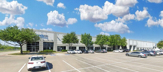
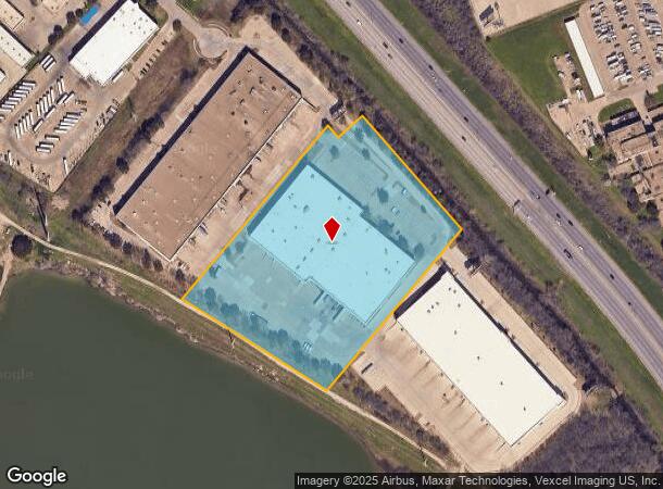
Property Record
9755 Clifford Dr, Dallas, TX 75220


Current Lease Availabilities
NEARBY LISTINGS FOR SALE OR LEASE
Property Detail
9755 Clifford Dr
Dallas-Fort Worth-Arlington, TX
Stemmons Storey
005797000B05D0200
STEMMONS STOREY BLK B/5797 LT 5D.2 ACS 8.25 INT202300132687 DD06292023 CO-DC 5797 00B 05D02 6DA5797 00B
Officebuilding
Dallas
AE
Texas
48113C0310J
5d
2024
8.25 AC
2025
West Brookhollow
010003
Dallas/Ft Worth
114,500 SF
DEMOGRAPHICS near 9755 Clifford Dr
1 Mile
3 Mile
5 Mile
2024 Total Population
5,260
64,264
255,855
2029 Population
5,235
64,249
256,119
Pop Growth 2024-2029
(0.48%)
(0.02%)
+ 0.10%
Average Age
32
35
36
2024 Total Households
1,813
23,130
101,974
HH Growth 2024-2029
(0.77%)
(0.08%)
+ 0.22%
Median Household Inc
$39,236
$55,200
$71,669
Avg Household Size
2.80
2.70
2.40
2024 Avg HH Vehicles
1.00
2.00
2.00
Median Home Value
$420,000
$326,553
$374,642
Median Year Built
1968
1974
1982
Nearby Places
Map Layers
Map Styles
 Street
 Aerial
- Restaurants
- Banks
- Shops
- Fitness
- Groceries
PUBLIC TRANSPORTATION
TRANSIT/SUBWAY
Bachman Station (DART LIGHT RAIL - GREEN LINE - Dallas Area Rapid Transit (DART), DART LIGHT RAIL - ORANGE LINE - Dallas Area Rapid Transit (DART), Green Line - Dallas Area Rapid Transit (DART), Orange Line - Dallas Area Rapid Transit (DART))
DRIVE
WALK
Distance
Bachman Station (DART LIGHT RAIL - GREEN LINE - Dallas Area Rapid Transit (DART), DART LIGHT RAIL - ORANGE LINE - Dallas Area Rapid Transit (DART), Green Line - Dallas Area Rapid Transit (DART), Orange Line - Dallas Area Rapid Transit (DART))
4 min
7 min
0.4 mi
COMMUTER RAIL
Medical/Market Ctr Station (TRINITY RAILWAY - Dallas Area Rapid Transit (DART))
DRIVE
WALK
Distance
Medical/Market Ctr Station (TRINITY RAILWAY - Dallas Area Rapid Transit (DART))
11 min
6.1 mi
Medical/Market Center (Trinity Railway Express - Dallas Area Rapid Transit (DART))
DRIVE
WALK
Distance
Medical/Market Center (Trinity Railway Express - Dallas Area Rapid Transit (DART))
11 min
6.1 mi
AIRPORT
Dallas Love Field
DRIVE
WALK
Distance
Dallas Love Field
12 min
5.2 mi
Dallas-Fort Worth International
DRIVE
WALK
Distance
Dallas-Fort Worth International
21 min
14.4 mi
Freight Ports
Port of Shreveport
DRIVE
WALK
Distance
Port of Shreveport
226 min
206.2 mi
Nearby Properties
Address
Land Use
TOTAL SIZE
Lot Size
Zoning
Address
Land Use
TOTAL SIZE
Lot Size
Zoning
2,476 SF
1,203.03 AC
Z116
Address
Land Use
TOTAL SIZE
Lot Size
Zoning
2,271,924 SF
Address
Land Use
TOTAL SIZE
Lot Size
Zoning
4,407,366 SF
1,300 AC
IR
Address
Land Use
TOTAL SIZE
Lot Size
Zoning
584,652 SF
22.90 AC
Z150
Address
Land Use
TOTAL SIZE
Lot Size
Zoning
30,000 SF
78.01 AC
Z392
Address
Land Use
TOTAL SIZE
Lot Size
Zoning
1,898,977 SF
42.38 AC
Z239
Address
Land Use
TOTAL SIZE
Lot Size
Zoning
729,266 SF
10.20 AC
Z239
Address
Land Use
TOTAL SIZE
Lot Size
Zoning
654,829 SF
9.78 AC
Z243
Address
Land Use
TOTAL SIZE
Lot Size
Zoning
608,308 SF
7.26 AC
Z198
Address
Land Use
TOTAL SIZE
Lot Size
Zoning
618,535 SF
1,300 AC
IR
Address
Land Use
TOTAL SIZE
Lot Size
Zoning
641,711 SF
5.38 AC
Z239
Address
Land Use
TOTAL SIZE
Lot Size
Zoning
260,521 SF
30.07 AC
Z150
Address
Land Use
TOTAL SIZE
Lot Size
Zoning
253,580 SF
188.04 AC
Z393
Address
Land Use
TOTAL SIZE
Lot Size
Zoning
529,640 SF
5.13 AC
Z393
Address
Land Use
TOTAL SIZE
Lot Size
Zoning
558,547 SF
7.39 AC
Z198
Address
Land Use
TOTAL SIZE
Lot Size
Zoning
507,008 SF
5.07 AC
Z239
Address
Land Use
TOTAL SIZE
Lot Size
Zoning
533,342 SF
5.86 AC
Z239
Address
Land Use
TOTAL SIZE
Lot Size
Zoning
1,333,090 SF
19.81 AC
Z150
Address
Land Use
TOTAL SIZE
Lot Size
Zoning
685,774 SF
7.36 AC
Z198
Address
Land Use
TOTAL SIZE
Lot Size
Zoning
621,941 SF
10.53 AC
Z239
Address
Land Use
TOTAL SIZE
Lot Size
Zoning
174,728 SF
223.82 AC
Z298
Address
Land Use
TOTAL SIZE
Lot Size
Zoning
343,192 SF
14.99 AC
Z151
Address
Land Use
TOTAL SIZE
Lot Size
Zoning
1,102,000 SF
4.98 AC
Z393
Address
Land Use
TOTAL SIZE
Lot Size
Zoning
388,822 SF
19.97 AC
Z116
Address
Land Use
TOTAL SIZE
Lot Size
Zoning
310,154 SF
10.33 AC
Z393
Address
Land Use
TOTAL SIZE
Lot Size
Zoning
840,836 SF
4.13 AC
Z393
Address
Land Use
TOTAL SIZE
Lot Size
Zoning
348,013 SF
11.09 AC
Z243
Address
Land Use
TOTAL SIZE
Lot Size
Zoning
468,318 SF
3.32 AC
Z151
Address
Land Use
TOTAL SIZE
Lot Size
Zoning
320,841 SF
12.64 AC
Z59
Address
Land Use
TOTAL SIZE
Lot Size
Zoning
178,900 SF
15.93 AC
Z164
The World's #1 Commercial Real Estate Marketplace
Connect with us
© 2026 CoStar Group
The information above has been obtained from sources believed reliable. While we do not doubt its accuracy we have not verified it and make no guarantee, warranty or representation about it. It is your responsibility to independently confirm its accuracy and completeness. Any projections, opinions, assumptions, or estimates used are for example only and do not represent the current or future performance of the property. The value of this transaction to you depends on tax and other factors which should be evaluated by your tax, financial, and legal advisors. You and your advisors should conduct a careful, independent investigation of the property to determine to your satisfaction the suitability of the property for your needs.