Property Record
9755 Randall Dr, Carmel, IN 46280

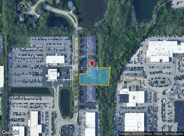
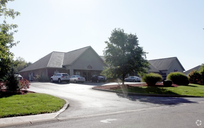
This Property Is For Sale
NEARBY LISTINGS FOR SALE OR LEASE
Property Detail
9755 Randall Dr
29-14-08-005-004.002-018
E 96Th St Auto Park
Officebuilding
ACREAGE 1.02, SECTION 8, TOWNSHIP 17, RANGE 4, E 96TH ST AUTO PARK, BLOCK PT A
AE
Hamilton
18097C0061F
Indiana
2023
1.02 AC
2024
Keystone Crossing
111101
Indianapolis
6,006 SF
Indianapolis-Carmel-Anderson, IN
DEMOGRAPHICS near 9755 Randall Dr
1 Mile
3 Mile
5 Mile
2024 Total Population
4,116
59,298
172,848
2029 Population
4,382
62,398
182,948
Pop Growth 2024-2029
+ 6.46%
+ 5.23%
+ 5.84%
Average Age
38
41
41
2024 Total Households
1,963
27,706
77,171
HH Growth 2024-2029
+ 4.84%
+ 4.45%
+ 5.40%
Median Household Inc
$63,030
$74,219
$84,669
Avg Household Size
2.10
2.10
2.20
2024 Avg HH Vehicles
2.00
2.00
2.00
Median Home Value
$356,710
$303,028
$300,964
Median Year Built
1986
1983
1984
Nearby Places
Map Layers
Map Styles
 Street
 Aerial
- Restaurants
- Banks
- Shops
- Fitness
- Groceries
PUBLIC TRANSPORTATION
AIRPORT
Indianapolis International
DRIVE
WALK
Distance
Indianapolis International
50 min
30.7 mi
Freight Ports
Port of Toledo
DRIVE
WALK
Distance
Port of Toledo
256 min
215.1 mi
Nearby Properties
Address
Land Use
TOTAL SIZE
Lot Size
Zoning
Address
Land Use
TOTAL SIZE
Lot Size
Zoning
21,742 SF
39.35 AC
ZO01
Address
Land Use
TOTAL SIZE
Lot Size
Zoning
8,551 SF
45.92 AC
ZO01
Address
Land Use
TOTAL SIZE
Lot Size
Zoning
16,704 SF
109.83 AC
ZO01
Address
Land Use
TOTAL SIZE
Lot Size
Zoning
4,146 SF
45.91 AC
ZO01
Address
Land Use
TOTAL SIZE
Lot Size
Zoning
328,241 SF
91.83 AC
Address
Land Use
TOTAL SIZE
Lot Size
Zoning
315,968 SF
0.06 AC
ZO01
Address
Land Use
TOTAL SIZE
Lot Size
Zoning
408,298 SF
15.67 AC
Address
Land Use
TOTAL SIZE
Lot Size
Zoning
317,335 SF
4.22 AC
Address
Land Use
TOTAL SIZE
Lot Size
Zoning
117,212 SF
2.81 AC
Address
Land Use
TOTAL SIZE
Lot Size
Zoning
3,053 SF
10.33 AC
ZO01
Address
Land Use
TOTAL SIZE
Lot Size
Zoning
428,056 SF
20.27 AC
Address
Land Use
TOTAL SIZE
Lot Size
Zoning
345 SF
6.39 AC
ZO01
Address
Land Use
TOTAL SIZE
Lot Size
Zoning
5,314 SF
13.92 AC
ZO01
Address
Land Use
TOTAL SIZE
Lot Size
Zoning
107,078 SF
15.66 AC
ZO01
Address
Land Use
TOTAL SIZE
Lot Size
Zoning
125.31 AC
Address
Land Use
TOTAL SIZE
Lot Size
Zoning
290,488 SF
13.72 AC
Address
Land Use
TOTAL SIZE
Lot Size
Zoning
8,157 SF
113.93 AC
ZO01
Address
Land Use
TOTAL SIZE
Lot Size
Zoning
6,252 SF
52.04 AC
ZO01
Address
Land Use
TOTAL SIZE
Lot Size
Zoning
288 SF
7.35 AC
ZO01
Address
Land Use
TOTAL SIZE
Lot Size
Zoning
158,839 SF
0.06 AC
Address
Land Use
TOTAL SIZE
Lot Size
Zoning
1,904 SF
67.93 AC
ZO01
Address
Land Use
TOTAL SIZE
Lot Size
Zoning
6,229 SF
36.20 AC
ZO01
Address
Land Use
TOTAL SIZE
Lot Size
Zoning
3,316 SF
8.91 AC
ZO01
Address
Land Use
TOTAL SIZE
Lot Size
Zoning
229,554 SF
11.78 AC
ZO01
Address
Land Use
TOTAL SIZE
Lot Size
Zoning
217,633 SF
78.75 AC
Address
Land Use
TOTAL SIZE
Lot Size
Zoning
235,807 SF
12.92 AC
Address
Land Use
TOTAL SIZE
Lot Size
Zoning
285,284 SF
7.78 AC
Address
Land Use
TOTAL SIZE
Lot Size
Zoning
10,514 SF
15.75 AC
ZO01
Address
Land Use
TOTAL SIZE
Lot Size
Zoning
1,700 SF
33.14 AC
ZO01
Address
Land Use
TOTAL SIZE
Lot Size
Zoning
360,178 SF
36 AC
The World's #1 Commercial Real Estate Marketplace
Connect with us
© 2026 CoStar Group
The information above has been obtained from sources believed reliable. While we do not doubt its accuracy we have not verified it and make no guarantee, warranty or representation about it. It is your responsibility to independently confirm its accuracy and completeness. Any projections, opinions, assumptions, or estimates used are for example only and do not represent the current or future performance of the property. The value of this transaction to you depends on tax and other factors which should be evaluated by your tax, financial, and legal advisors. You and your advisors should conduct a careful, independent investigation of the property to determine to your satisfaction the suitability of the property for your needs.