Property Record
725 Peanut Rd, Woodruff, SC 29388
NEARBY LISTINGS FOR SALE OR LEASE
Property Detail
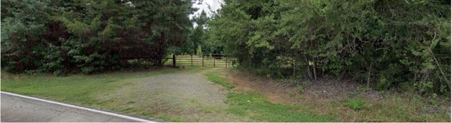
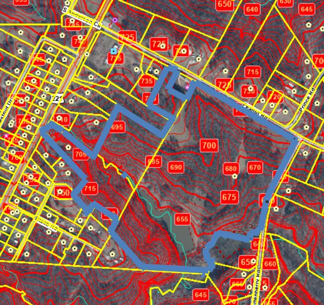
725 Peanut Rd
Spartanburg, SC
Leon M & Linda F Metcalf
4-25-00-130.01
S SIDE RD 119 W SIDE SC HWY 453 PB 101-494 DB 53J-814-837
Agriculturalland
Spartanburg
X
South Carolina
45059C0050C
59.34 AC
2024
Lower Spartanburg County
2025
Greenville/Spartanburg
023500
DEMOGRAPHICS near 725 Peanut Rd
1 Mile
3 Mile
5 Mile
2024 Total Population
1,009
8,677
13,226
2029 Population
1,157
9,949
15,087
Pop Growth 2024-2029
+ 14.67%
+ 14.66%
+ 14.07%
Average Age
41
41
41
2024 Total Households
401
3,401
5,165
HH Growth 2024-2029
+ 14.96%
+ 14.94%
+ 14.35%
Median Household Inc
$75,490
$67,326
$65,415
Avg Household Size
2.50
2.50
2.50
2024 Avg HH Vehicles
2.00
2.00
2.00
Median Home Value
$238,983
$185,351
$192,280
Median Year Built
1985
1988
1989
Nearby Places
Map Layers
Map Styles
 Street
 Aerial
- Restaurants
- Banks
- Shops
- Fitness
- Groceries
PUBLIC TRANSPORTATION
AIRPORT
Greenville Spartanburg International
DRIVE
WALK
Distance
Greenville Spartanburg International
37 min
19.7 mi
Freight Ports
North Charleston Terminal
DRIVE
WALK
Distance
North Charleston Terminal
211 min
183.9 mi
SALE & LEASE HISTORY
LISTING DATE
SALE/LEASE

Oct 18, 2022
For Sale
Nearby Properties
Address
Land Use
TOTAL SIZE
Lot Size
Zoning
Address
Land Use
TOTAL SIZE
Lot Size
Zoning
825 SF
5 AC
Address
Land Use
TOTAL SIZE
Lot Size
Zoning
128.91 AC
Address
Land Use
TOTAL SIZE
Lot Size
Zoning
118.46 AC
Address
Land Use
TOTAL SIZE
Lot Size
Zoning
10,326 SF
314.80 AC
Address
Land Use
TOTAL SIZE
Lot Size
Zoning
48,964 SF
10.58 AC
Address
Land Use
TOTAL SIZE
Lot Size
Zoning
1,573 SF
38.19 AC
Address
Land Use
TOTAL SIZE
Lot Size
Zoning
5,648 SF
Address
Land Use
TOTAL SIZE
Lot Size
Zoning
13,758 SF
3.29 AC
Address
Land Use
TOTAL SIZE
Lot Size
Zoning
5,182 SF
0.77 AC
Address
Land Use
TOTAL SIZE
Lot Size
Zoning
2,744 SF
2.18 AC
Address
Land Use
TOTAL SIZE
Lot Size
Zoning
14,155 SF
1.67 AC
Address
Land Use
TOTAL SIZE
Lot Size
Zoning
161,104 SF
5.09 AC
Address
Land Use
TOTAL SIZE
Lot Size
Zoning
2,599 SF
0.67 AC
Address
Land Use
TOTAL SIZE
Lot Size
Zoning
3,731 SF
5 AC
Address
Land Use
TOTAL SIZE
Lot Size
Zoning
4,067 SF
0.93 AC
Address
Land Use
TOTAL SIZE
Lot Size
Zoning
4,456 SF
0.79 AC
Address
Land Use
TOTAL SIZE
Lot Size
Zoning
2,262 SF
0.21 AC
Address
Land Use
TOTAL SIZE
Lot Size
Zoning
47.19 AC
Address
Land Use
TOTAL SIZE
Lot Size
Zoning
43,925 SF
3.46 AC
Address
Land Use
TOTAL SIZE
Lot Size
Zoning
2,748 SF
0.14 AC
Address
Land Use
TOTAL SIZE
Lot Size
Zoning
3,564 SF
2.40 AC
Address
Land Use
TOTAL SIZE
Lot Size
Zoning
Address
Land Use
TOTAL SIZE
Lot Size
Zoning
24,145 SF
8.19 AC
Address
Land Use
TOTAL SIZE
Lot Size
Zoning
6,243 SF
7.09 AC
Address
Land Use
TOTAL SIZE
Lot Size
Zoning
12,313 SF
1.53 AC
Address
Land Use
TOTAL SIZE
Lot Size
Zoning
2,354 SF
1.41 AC
Address
Land Use
TOTAL SIZE
Lot Size
Zoning
2,402 SF
3.21 AC
Address
Land Use
TOTAL SIZE
Lot Size
Zoning
3,269 SF
1.61 AC
Address
Land Use
TOTAL SIZE
Lot Size
Zoning
10,874 SF
0.40 AC
Address
Land Use
TOTAL SIZE
Lot Size
Zoning
3,396 SF
0.45 AC
The World's #1 Commercial Real Estate Marketplace
Connect with us
© 2025 CoStar Group
The information above has been obtained from sources believed reliable. While we do not doubt its accuracy we have not verified it and make no guarantee, warranty or representation about it. It is your responsibility to independently confirm its accuracy and completeness. Any projections, opinions, assumptions, or estimates used are for example only and do not represent the current or future performance of the property. The value of this transaction to you depends on tax and other factors which should be evaluated by your tax, financial, and legal advisors. You and your advisors should conduct a careful, independent investigation of the property to determine to your satisfaction the suitability of the property for your needs.