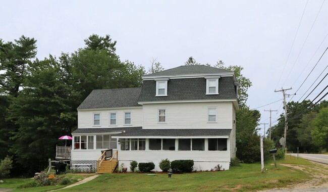
Property Record
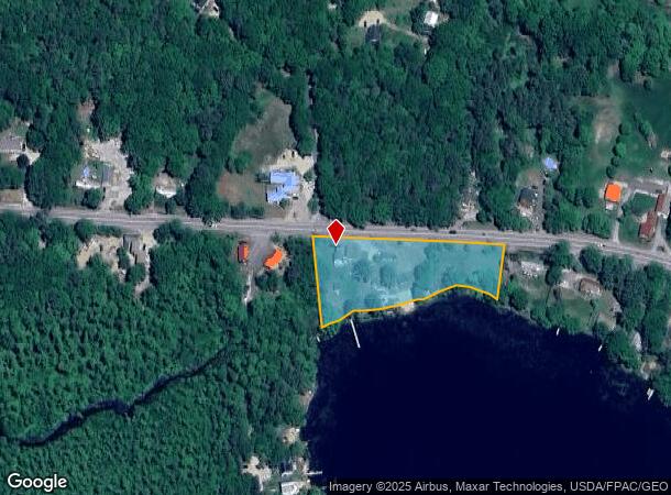
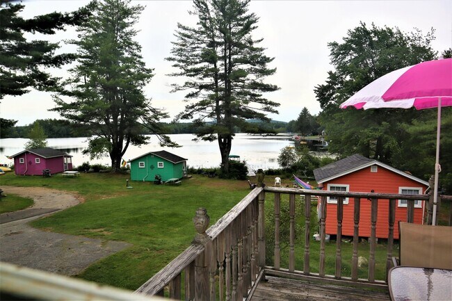
977 1St Nh Tpke, Northwood, NH 03261
NEARBY LISTINGS FOR SALE OR LEASE
-
-
View all Northwood listings for sale on LoopNet.com
Property Detail
977 1St Nh Tpke
NWOO-000217-000000-000009
Rockingham
Multifamilydwelling
New Hampshire
A
9
33015C0080E
1.70 AC
2024
Concord/New Hampshire North Area
2024
Boston
057000
Boston-Cambridge-Newton, MA-NH
DEMOGRAPHICS near 977 1St Nh Tpke
1 Mile
3 Mile
5 Mile
2024 Total Population
616
4,470
10,337
2029 Population
649
4,685
10,789
Pop Growth 2024-2029
+ 5.36%
+ 4.81%
+ 4.37%
Average Age
43
43
43
2024 Total Households
247
1,754
3,976
HH Growth 2024-2029
+ 5.26%
+ 4.73%
+ 4.35%
Median Household Inc
$114,870
$117,169
$111,438
Avg Household Size
2.50
2.50
2.60
2024 Avg HH Vehicles
2.00
2.00
2.00
Median Home Value
$353,448
$356,818
$360,890
Median Year Built
1967
1972
1979
Nearby Places
Map Layers
Map Styles
 Street
 Aerial
- Restaurants
- Banks
- Shops
- Fitness
- Groceries
PUBLIC TRANSPORTATION
AIRPORT
Portsmouth International at Pease
DRIVE
WALK
Distance
Portsmouth International at Pease
43 min
25.9 mi
Manchester Boston Regional
DRIVE
WALK
Distance
Manchester Boston Regional
60 min
34.6 mi
Freight Ports
Portland, ME
DRIVE
WALK
Distance
Portland, ME
101 min
67.8 mi
SALE & LEASE HISTORY
LISTING DATE
SALE/LEASE

Nov 02, 2021
For Sale
Nearby Properties
Address
Land Use
TOTAL SIZE
Lot Size
Zoning
Address
Land Use
TOTAL SIZE
Lot Size
Zoning
10 AC
HRVY H
Address
Land Use
TOTAL SIZE
Lot Size
Zoning
886 SF
286 AC
NWL RN
Address
Land Use
TOTAL SIZE
Lot Size
Zoning
71,548 SF
27 AC
GENERA
Address
Land Use
TOTAL SIZE
Lot Size
Zoning
55 AC
GENERA
Address
Land Use
TOTAL SIZE
Lot Size
Zoning
35.62 AC
GENERA
Address
Land Use
TOTAL SIZE
Lot Size
Zoning
25,175 SF
7 AC
GENERA
Address
Land Use
TOTAL SIZE
Lot Size
Zoning
16,575 SF
14.55 AC
GENERA
Address
Land Use
TOTAL SIZE
Lot Size
Zoning
19,587 SF
5.03 AC
JERRJE
Address
Land Use
TOTAL SIZE
Lot Size
Zoning
3,075 SF
2.06 AC
GENERA
Address
Land Use
TOTAL SIZE
Lot Size
Zoning
0.63 AC
BOWRRB
Address
Land Use
TOTAL SIZE
Lot Size
Zoning
1.92 AC
GENERA
Address
Land Use
TOTAL SIZE
Lot Size
Zoning
20,500 SF
3.46 AC
GENERA
Address
Land Use
TOTAL SIZE
Lot Size
Zoning
2,456 SF
30.09 AC
GENERA
Address
Land Use
TOTAL SIZE
Lot Size
Zoning
1,680 SF
5.23 AC
Address
Land Use
TOTAL SIZE
Lot Size
Zoning
413 SF
5.56 AC
NWL RN
Address
Land Use
TOTAL SIZE
Lot Size
Zoning
21,459 SF
15.31 AC
GENERA
Address
Land Use
TOTAL SIZE
Lot Size
Zoning
6,708 SF
300 AC
LONG P
Address
Land Use
TOTAL SIZE
Lot Size
Zoning
10,671 SF
2 AC
GENERA
Address
Land Use
TOTAL SIZE
Lot Size
Zoning
0.69 AC
PL RRP
Address
Land Use
TOTAL SIZE
Lot Size
Zoning
3.60 AC
NWL RN
Address
Land Use
TOTAL SIZE
Lot Size
Zoning
1.58 AC
PL RRP
Address
Land Use
TOTAL SIZE
Lot Size
Zoning
0.62 AC
BOWRRB
Address
Land Use
TOTAL SIZE
Lot Size
Zoning
1.20 AC
BOWRRB
Address
Land Use
TOTAL SIZE
Lot Size
Zoning
15,978 SF
2.02 AC
GENERA
Address
Land Use
TOTAL SIZE
Lot Size
Zoning
0.50 AC
PL RRP
Address
Land Use
TOTAL SIZE
Lot Size
Zoning
8,552 SF
0.36 AC
GENERA
Address
Land Use
TOTAL SIZE
Lot Size
Zoning
3,917 SF
17 AC
LONG P
Address
Land Use
TOTAL SIZE
Lot Size
Zoning
1.10 AC
NWL RN
Address
Land Use
TOTAL SIZE
Lot Size
Zoning
13,036 SF
3.02 AC
GENERA
Address
Land Use
TOTAL SIZE
Lot Size
Zoning
3,526 SF
15.12 AC
GENERA
The World's #1 Commercial Real Estate Marketplace
Connect with us
© 2026 CoStar Group
The information above has been obtained from sources believed reliable. While we do not doubt its accuracy we have not verified it and make no guarantee, warranty or representation about it. It is your responsibility to independently confirm its accuracy and completeness. Any projections, opinions, assumptions, or estimates used are for example only and do not represent the current or future performance of the property. The value of this transaction to you depends on tax and other factors which should be evaluated by your tax, financial, and legal advisors. You and your advisors should conduct a careful, independent investigation of the property to determine to your satisfaction the suitability of the property for your needs.