Property Record
977 E 149Th St, Bronx, NY 10455
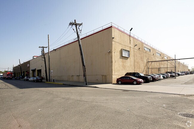

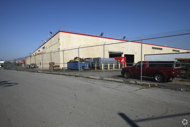

Property Detail
977 E 149Th St
02604-0252
Bronx
Warehouse
New York
M3-1
252
VE and V1-30 Coastal areas with a 1% or greater chance of flooding and an additional hazard associated with storm waves. These areas have a 26% chance of flooding over the life of a 30-year mortgage.
11.28 AC
2024
Bronx
2025
Westchester/So Connecticut
009302
New York-Jersey City-White Plains, NY-NJ
213,776 SF
NEARBY LISTINGS FOR SALE OR LEASE
DEMOGRAPHICS near 977 E 149Th St
1 mile
3 mile
5 mile
2025 Total Population
63,809
1,030,068
2,870,009
2030 Population
62,504
1,032,827
2,890,778
Pop Growth 2025-2030
(2.05%)
+ 0.27%
+ 0.72%
Average Age
36
39
40
2025 Total Households
21,021
385,086
1,119,825
HH Growth 2025-2030
(2.74%)
+ 0.36%
+ 1.16%
Median Household Inc
$36,360
$46,817
$67,855
Avg Household Size
2.80
2.50
2.40
2025 Avg HH Vehicles
.00
.00
.00
Median Home Value
$591,135
$691,757
$803,524
Median Year Built
1963
1957
1952
Nearby Places
Map Layers
Map Styles
 Street
 Aerial
Transit
 Traffic
 Biking
Places
Listings with unknown addresses are not visible on the map
- Restaurants
- Banks
- Shops
- Fitness
- Groceries
PUBLIC TRANSPORTATION
TRANSIT/SUBWAY
East 149 Street (6 - New York MTA Subway (The Subway))
Drive
Walk
Distance
East 149 Street (6 - New York MTA Subway (The Subway))
1 min
9 min
0.5 mi
East 143 Street-St Marys Street (6 - New York MTA Subway (The Subway))
Drive
Walk
Distance
East 143 Street-St Marys Street (6 - New York MTA Subway (The Subway))
2 min
12 min
0.6 mi
Longwood Avenue (6 - New York MTA Subway (The Subway))
Drive
Walk
Distance
Longwood Avenue (6 - New York MTA Subway (The Subway))
2 min
18 min
1.0 mi
Jackson Avenue (2 - New York MTA Subway (The Subway), 5 - New York MTA Subway (The Subway))
Drive
Walk
Distance
Jackson Avenue (2 - New York MTA Subway (The Subway), 5 - New York MTA Subway (The Subway))
3 min
19 min
1.0 mi
Cypress Avenue (6 - New York MTA Subway (The Subway))
Drive
Walk
Distance
Cypress Avenue (6 - New York MTA Subway (The Subway))
2 min
20 min
1.0 mi
COMMUTER RAIL
Melrose Station (Harlem Line - Metro-North Commuter Railroad Company (Metro-North))
Drive
Walk
Distance
Melrose Station (Harlem Line - Metro-North Commuter Railroad Company (Metro-North))
7 min
2.4 mi
Harlem-125Th Street Station (Harlem Line - Metro-North Commuter Railroad Company (Metro-North), Hudson Line - Metro-North Commuter Railroad Company (Metro-North), New Haven Line - Metro-North Commuter Railroad Company (Metro-North))
Drive
Walk
Distance
Harlem-125Th Street Station (Harlem Line - Metro-North Commuter Railroad Company (Metro-North), Hudson Line - Metro-North Commuter Railroad Company (Metro-North), New Haven Line - Metro-North Commuter Railroad Company (Metro-North))
6 min
3.0 mi
AIRPORT
LaGuardia
Drive
Walk
Distance
LaGuardia
14 min
6.8 mi
John F Kennedy International
Drive
Walk
Distance
John F Kennedy International
27 min
18.0 mi
Newark Liberty International
Drive
Walk
Distance
Newark Liberty International
31 min
25.4 mi
Freight Ports
NY - Red Hook Container Terminal
Drive
Walk
Distance
NY - Red Hook Container Terminal
27 min
15.0 mi
Nearby Properties
Address
Land Use
TOTAL SIZE
Lot Size
Zoning
Address
Land Use
TOTAL SIZE
Lot Size
Zoning
5,519,372 SF
409.21 AC
C8-2
Address
Land Use
TOTAL SIZE
Lot Size
Zoning
400,160 SF
10.96 AC
R7-2
Address
Land Use
TOTAL SIZE
Lot Size
Zoning
2,215,000 SF
6.43 AC
R9
Address
Land Use
TOTAL SIZE
Lot Size
Zoning
2,278,432 SF
5.99 AC
R7-2
Address
Land Use
TOTAL SIZE
Lot Size
Zoning
755,000 SF
1.85 AC
R7-2
Address
Land Use
TOTAL SIZE
Lot Size
Zoning
873,000 SF
9.95 AC
R7-2
Address
Land Use
TOTAL SIZE
Lot Size
Zoning
1,075,000 SF
6.74 AC
R7-2
Address
Land Use
TOTAL SIZE
Lot Size
Zoning
1,311,800 SF
9.89 AC
C4-4
Address
Land Use
TOTAL SIZE
Lot Size
Zoning
908,799 SF
2.13 AC
R10
Address
Land Use
TOTAL SIZE
Lot Size
Zoning
207.09 AC
PARK
Address
Land Use
TOTAL SIZE
Lot Size
Zoning
422,000 SF
0.86 AC
R9
Address
Land Use
TOTAL SIZE
Lot Size
Zoning
1,012,000 SF
7.79 AC
R6
Address
Land Use
TOTAL SIZE
Lot Size
Zoning
507,265 SF
4.04 AC
C4-4
Address
Land Use
TOTAL SIZE
Lot Size
Zoning
892,550 SF
2.93 AC
M13R8
Address
Land Use
TOTAL SIZE
Lot Size
Zoning
948 SF
282.37 AC
PARK
Address
Land Use
TOTAL SIZE
Lot Size
Zoning
2,531,670 SF
17.15 AC
R7-2
Address
Land Use
TOTAL SIZE
Lot Size
Zoning
94,247 SF
8.63 AC
M1-4
Address
Land Use
TOTAL SIZE
Lot Size
Zoning
217,951 SF
0.91 AC
R6
Address
Land Use
TOTAL SIZE
Lot Size
Zoning
620,000 SF
3.31 AC
R7-2
Address
Land Use
TOTAL SIZE
Lot Size
Zoning
480,769 SF
1.21 AC
R8
Address
Land Use
TOTAL SIZE
Lot Size
Zoning
276,285 SF
1.26 AC
R7-2
Address
Land Use
TOTAL SIZE
Lot Size
Zoning
130,228 SF
0.59 AC
R8
Address
Land Use
TOTAL SIZE
Lot Size
Zoning
293,848 SF
2.98 AC
C8-3
Address
Land Use
TOTAL SIZE
Lot Size
Zoning
426,172 SF
14.30 AC
M3-1
Address
Land Use
TOTAL SIZE
Lot Size
Zoning
491,007 SF
11.85 AC
M3-1
Address
Land Use
TOTAL SIZE
Lot Size
Zoning
7,500 SF
14.56 AC
PARK
Address
Land Use
TOTAL SIZE
Lot Size
Zoning
566,233 SF
13.25 AC
M3-1
Address
Land Use
TOTAL SIZE
Lot Size
Zoning
509,090 SF
0.94 AC
R10
Address
Land Use
TOTAL SIZE
Lot Size
Zoning
655,459 SF
1.13 AC
C2-8
Address
Land Use
TOTAL SIZE
Lot Size
Zoning
291,885 SF
8.86 AC
R8
The World's #1 Commercial Real Estate Marketplace
Connect with us
© 2026 CoStar Group
The information above has been obtained from sources believed reliable. While we do not doubt its accuracy we have not verified it and make no guarantee, warranty or representation about it. It is your responsibility to independently confirm its accuracy and completeness. Any projections, opinions, assumptions, or estimates used are for example only and do not represent the current or future performance of the property. The value of this transaction to you depends on tax and other factors which should be evaluated by your tax, financial, and legal advisors. You and your advisors should conduct a careful, independent investigation of the property to determine to your satisfaction the suitability of the property for your needs.