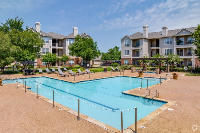
Property Record
9777 N Council Rd, Oklahoma City, OK 73162

NEARBY LISTINGS FOR SALE OR LEASE
-
-
View all Oklahoma City listings for sale on LoopNet.com
Property Detail
9777 N Council Rd
140933040
Unpltd Pt Sec 30 13N 4W
Multifamilydwelling
UNPLTD PT SEC 30 13N 4W 000 000 PT SE4 SEC 30 13N 4W BEG 300FT S OF NE/C SE4 TH W1088.97FT S502.62FT SWLY79.29FT W365.26FT SWLY385.92FT SELY426.51FT NELY128.47FT E325.85FT N160FT NELY188.53FT NELY205FT NELY99.94FT NELY146.39FT NELY87.54FT NE25FT NWLY
X
Oklahoma
40109C0135H
Oklahoma
2023
14.86 AC
2024
Harvest Hills
108523
Oklahoma City
281,480 SF
Oklahoma City, OK
DEMOGRAPHICS near 9777 N Council Rd
1 Mile
3 Mile
5 Mile
2024 Total Population
13,349
72,129
146,622
2029 Population
13,569
75,646
156,367
Pop Growth 2024-2029
+ 1.65%
+ 4.88%
+ 6.65%
Average Age
41
39
39
2024 Total Households
5,770
29,322
59,191
HH Growth 2024-2029
+ 1.70%
+ 4.55%
+ 6.13%
Median Household Inc
$60,563
$70,292
$71,632
Avg Household Size
2.20
2.40
2.40
2024 Avg HH Vehicles
2.00
2.00
2.00
Median Home Value
$170,814
$217,054
$217,330
Median Year Built
1984
1985
1983
Nearby Places
Map Layers
Map Styles
 Street
 Aerial
- Restaurants
- Banks
- Shops
- Fitness
- Groceries
PUBLIC TRANSPORTATION
AIRPORT
Will Rogers World
DRIVE
WALK
Distance
Will Rogers World
29 min
16.4 mi
Freight Ports
Tulsa Port Of Catoosa
DRIVE
WALK
Distance
Tulsa Port Of Catoosa
139 min
127.5 mi
Nearby Properties
Address
Land Use
TOTAL SIZE
Lot Size
Zoning
Address
Land Use
TOTAL SIZE
Lot Size
Zoning
823,638 SF
94.89 AC
PUD
Address
Land Use
TOTAL SIZE
Lot Size
Zoning
7,500 SF
55.85 AC
Address
Land Use
TOTAL SIZE
Lot Size
Zoning
37,400 SF
4.23 AC
PUD
Address
Land Use
TOTAL SIZE
Lot Size
Zoning
641,860 SF
62.12 AC
R-4
Address
Land Use
TOTAL SIZE
Lot Size
Zoning
356,798 SF
31.11 AC
C-3
Address
Land Use
TOTAL SIZE
Lot Size
Zoning
224,984 SF
12.72 AC
PUD
Address
Land Use
TOTAL SIZE
Lot Size
Zoning
175,991 SF
18.07 AC
SPUD
Address
Land Use
TOTAL SIZE
Lot Size
Zoning
363,374 SF
15.85 AC
R-4
Address
Land Use
TOTAL SIZE
Lot Size
Zoning
211,560 SF
8.32 AC
R-4
Address
Land Use
TOTAL SIZE
Lot Size
Zoning
226,800 SF
30.07 AC
R-2
Address
Land Use
TOTAL SIZE
Lot Size
Zoning
263,560 SF
13.10 AC
R-4
Address
Land Use
TOTAL SIZE
Lot Size
Zoning
157,279 SF
15.07 AC
PUD
Address
Land Use
TOTAL SIZE
Lot Size
Zoning
110,006 SF
6.15 AC
C-3
Address
Land Use
TOTAL SIZE
Lot Size
Zoning
10,400 SF
5.19 AC
Address
Land Use
TOTAL SIZE
Lot Size
Zoning
153,065 SF
13.87 AC
C-3
Address
Land Use
TOTAL SIZE
Lot Size
Zoning
342,342 SF
27.20 AC
R-4
Address
Land Use
TOTAL SIZE
Lot Size
Zoning
245,768 SF
15.93 AC
Address
Land Use
TOTAL SIZE
Lot Size
Zoning
220,304 SF
19.54 AC
PUD
Address
Land Use
TOTAL SIZE
Lot Size
Zoning
199,832 SF
9.72 AC
PUD
Address
Land Use
TOTAL SIZE
Lot Size
Zoning
52,214 SF
6.91 AC
PUD
Address
Land Use
TOTAL SIZE
Lot Size
Zoning
243,906 SF
9.56 AC
C-3
Address
Land Use
TOTAL SIZE
Lot Size
Zoning
175,635 SF
17.14 AC
I-2
Address
Land Use
TOTAL SIZE
Lot Size
Zoning
6,400 SF
3.40 AC
Address
Land Use
TOTAL SIZE
Lot Size
Zoning
172,368 SF
10.72 AC
R-4
Address
Land Use
TOTAL SIZE
Lot Size
Zoning
69,410 SF
9 AC
PUD
Address
Land Use
TOTAL SIZE
Lot Size
Zoning
640 SF
9.58 AC
Address
Land Use
TOTAL SIZE
Lot Size
Zoning
202,744 SF
14 AC
R-4
Address
Land Use
TOTAL SIZE
Lot Size
Zoning
169,312 SF
8.45 AC
R-4
Address
Land Use
TOTAL SIZE
Lot Size
Zoning
36,037 SF
8.26 AC
PUD
The World's #1 Commercial Real Estate Marketplace
Connect with us
© 2026 CoStar Group
The information above has been obtained from sources believed reliable. While we do not doubt its accuracy we have not verified it and make no guarantee, warranty or representation about it. It is your responsibility to independently confirm its accuracy and completeness. Any projections, opinions, assumptions, or estimates used are for example only and do not represent the current or future performance of the property. The value of this transaction to you depends on tax and other factors which should be evaluated by your tax, financial, and legal advisors. You and your advisors should conduct a careful, independent investigation of the property to determine to your satisfaction the suitability of the property for your needs.