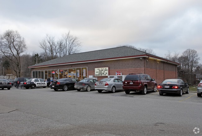
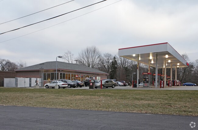
Property Record
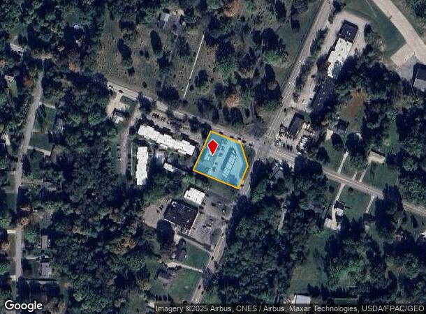
9780 Olde 8 Rd, Northfield, OH 44067
NEARBY LISTINGS FOR SALE OR LEASE
Property Detail
9780 Olde 8 Rd
Cleveland
Valleyview
Akron, OH
LOT 44 COR AK CLEVE & VALLEYVIEW .850A
45-02494
Summit
Servicestation
Ohio
2023
44
2025
0.76 AC
532705
Akron
4,018 SF
DEMOGRAPHICS near 9780 Olde 8 Rd
1 Mile
3 Mile
5 Mile
2024 Total Population
5,977
29,264
72,306
2029 Population
5,845
28,664
70,985
Pop Growth 2024-2029
(2.21%)
(2.05%)
(1.83%)
Average Age
45
46
45
2024 Total Households
2,547
12,549
30,767
HH Growth 2024-2029
(2.28%)
(2.12%)
(1.84%)
Median Household Inc
$96,572
$88,605
$78,564
Avg Household Size
2.30
2.30
2.30
2024 Avg HH Vehicles
2.00
2.00
2.00
Median Home Value
$242,910
$238,462
$232,152
Median Year Built
1989
1977
1975
Nearby Places
Map Layers
Map Styles
 Street
 Aerial
- Restaurants
- Banks
- Shops
- Fitness
- Groceries
PUBLIC TRANSPORTATION
COMMUTER RAIL
Brecksville (National Park Scenic Railway - Cuyahoga Valley Scenic Railroad)
DRIVE
WALK
Distance
Brecksville (National Park Scenic Railway - Cuyahoga Valley Scenic Railroad)
10 min
4.4 mi
Boston Mill (National Park Scenic Railway - Cuyahoga Valley Scenic Railroad)
DRIVE
WALK
Distance
Boston Mill (National Park Scenic Railway - Cuyahoga Valley Scenic Railroad)
14 min
6.3 mi
AIRPORT
Cleveland-Hopkins International
DRIVE
WALK
Distance
Cleveland-Hopkins International
39 min
21.2 mi
Akron-Canton Regional
DRIVE
WALK
Distance
Akron-Canton Regional
42 min
31.8 mi
Freight Ports
Port of Toledo
DRIVE
WALK
Distance
Port of Toledo
150 min
128.2 mi
Nearby Properties
Address
Land Use
TOTAL SIZE
Lot Size
Zoning
Address
Land Use
TOTAL SIZE
Lot Size
Zoning
376,124 SF
71.73 AC
Address
Land Use
TOTAL SIZE
Lot Size
Zoning
Address
Land Use
TOTAL SIZE
Lot Size
Zoning
49.31 AC
Address
Land Use
TOTAL SIZE
Lot Size
Zoning
Address
Land Use
TOTAL SIZE
Lot Size
Zoning
109.65 AC
MUD
Address
Land Use
TOTAL SIZE
Lot Size
Zoning
230,501 SF
39.59 AC
Address
Land Use
TOTAL SIZE
Lot Size
Zoning
155,897 SF
19.81 AC
Address
Land Use
TOTAL SIZE
Lot Size
Zoning
210,136 SF
21.69 AC
Address
Land Use
TOTAL SIZE
Lot Size
Zoning
201,034 SF
21.07 AC
I-2
Address
Land Use
TOTAL SIZE
Lot Size
Zoning
Address
Land Use
TOTAL SIZE
Lot Size
Zoning
130,822 SF
17.50 AC
Address
Land Use
TOTAL SIZE
Lot Size
Zoning
320,818 SF
12 AC
Address
Land Use
TOTAL SIZE
Lot Size
Zoning
105,438 SF
9.59 AC
Address
Land Use
TOTAL SIZE
Lot Size
Zoning
60,908 SF
46.85 AC
Address
Land Use
TOTAL SIZE
Lot Size
Zoning
99,400 SF
3.96 AC
Address
Land Use
TOTAL SIZE
Lot Size
Zoning
85,808 SF
10.20 AC
Address
Land Use
TOTAL SIZE
Lot Size
Zoning
Address
Land Use
TOTAL SIZE
Lot Size
Zoning
14,247 SF
262 AC
Address
Land Use
TOTAL SIZE
Lot Size
Zoning
Address
Land Use
TOTAL SIZE
Lot Size
Zoning
227,086 SF
16.65 AC
IG
Address
Land Use
TOTAL SIZE
Lot Size
Zoning
141,290 SF
11.53 AC
Address
Land Use
TOTAL SIZE
Lot Size
Zoning
30.90 AC
IG
Address
Land Use
TOTAL SIZE
Lot Size
Zoning
163,307 SF
9.90 AC
Address
Land Use
TOTAL SIZE
Lot Size
Zoning
64,145 SF
6.66 AC
Address
Land Use
TOTAL SIZE
Lot Size
Zoning
Address
Land Use
TOTAL SIZE
Lot Size
Zoning
247,000 SF
18.24 AC
IG
Address
Land Use
TOTAL SIZE
Lot Size
Zoning
32,400 SF
91.41 AC
IG
Address
Land Use
TOTAL SIZE
Lot Size
Zoning
79,986 SF
10.18 AC
Address
Land Use
TOTAL SIZE
Lot Size
Zoning
Address
Land Use
TOTAL SIZE
Lot Size
Zoning
120,260 SF
11.68 AC
The World's #1 Commercial Real Estate Marketplace
Connect with us
© 2026 CoStar Group
The information above has been obtained from sources believed reliable. While we do not doubt its accuracy we have not verified it and make no guarantee, warranty or representation about it. It is your responsibility to independently confirm its accuracy and completeness. Any projections, opinions, assumptions, or estimates used are for example only and do not represent the current or future performance of the property. The value of this transaction to you depends on tax and other factors which should be evaluated by your tax, financial, and legal advisors. You and your advisors should conduct a careful, independent investigation of the property to determine to your satisfaction the suitability of the property for your needs.