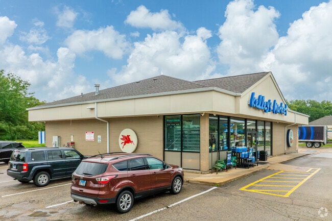
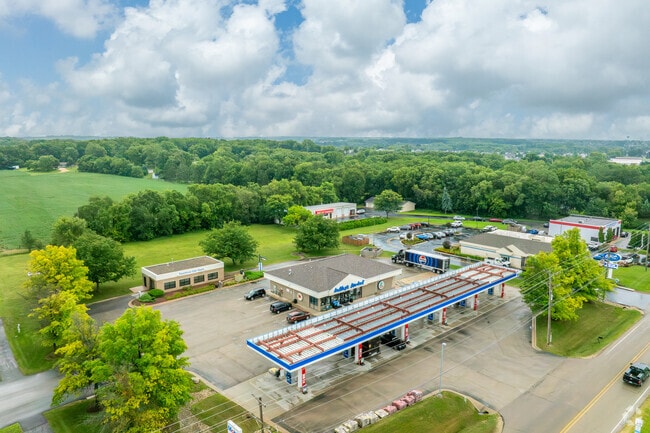
Property Record
9789 N 2Nd St, Roscoe, IL 61073

Property Detail
9789 N 2Nd St
08-04-451-006
MCDONALD CORNERS PT S1/2 SEC 4-45-2 LOT 1
Commercialnec
WINNEBAGO
CG - COMM
Illinois
B and X Area of moderate flood hazard, usually the area between the limits of the 100-year and 500-year floods.
1
2024
1.53 AC
2024
I-39 Corr/Winnebago Cnty
003805
Chicago
3,820 SF
Rockford, IL
NEARBY LISTINGS FOR SALE OR LEASE
DEMOGRAPHICS near 9789 N 2Nd St
1 mile
3 mile
5 mile
2025 Total Population
2,789
24,711
60,041
2030 Population
2,790
24,798
60,150
Pop Growth 2025-2030
+ 0.04%
+ 0.35%
+ 0.18%
Average Age
43
41
41
2025 Total Households
1,109
9,385
23,299
HH Growth 2025-2030
+ 0.09%
+ 0.40%
+ 0.19%
Median Household Inc
$85,500
$92,790
$87,371
Avg Household Size
2.50
2.60
2.50
2025 Avg HH Vehicles
2.00
2.00
2.00
Median Home Value
$223,265
$224,737
$202,610
Median Year Built
1994
1995
1989
Nearby Places
Map Layers
Map Styles
 Street
 Aerial
Transit
 Traffic
 Biking
Places
Listings with unknown addresses are not visible on the map
- Restaurants
- Banks
- Shops
- Fitness
- Groceries
PUBLIC TRANSPORTATION
AIRPORT
Chicago/Rockford International
Drive
Walk
Distance
Chicago/Rockford International
34 min
19.4 mi
Freight Ports
Port Milwaukee
Drive
Walk
Distance
Port Milwaukee
98 min
81.0 mi
Nearby Properties
Address
Land Use
TOTAL SIZE
Lot Size
Zoning
Address
Land Use
TOTAL SIZE
Lot Size
Zoning
105,664 SF
13.34 AC
Address
Land Use
TOTAL SIZE
Lot Size
Zoning
Address
Land Use
TOTAL SIZE
Lot Size
Zoning
192,604 SF
17.05 AC
Address
Land Use
TOTAL SIZE
Lot Size
Zoning
112,035 SF
8.79 AC
Address
Land Use
TOTAL SIZE
Lot Size
Zoning
175,502 SF
18.15 AC
Address
Land Use
TOTAL SIZE
Lot Size
Zoning
Address
Land Use
TOTAL SIZE
Lot Size
Zoning
Address
Land Use
TOTAL SIZE
Lot Size
Zoning
125,024 SF
9.91 AC
Address
Land Use
TOTAL SIZE
Lot Size
Zoning
124,757 SF
13.41 AC
Address
Land Use
TOTAL SIZE
Lot Size
Zoning
16,500 SF
10.62 AC
Address
Land Use
TOTAL SIZE
Lot Size
Zoning
140,888 SF
7.96 AC
Address
Land Use
TOTAL SIZE
Lot Size
Zoning
103,326 SF
10.52 AC
Address
Land Use
TOTAL SIZE
Lot Size
Zoning
Address
Land Use
TOTAL SIZE
Lot Size
Zoning
135,351 SF
19 AC
Address
Land Use
TOTAL SIZE
Lot Size
Zoning
10.16 AC
Address
Land Use
TOTAL SIZE
Lot Size
Zoning
85,350 SF
13.15 AC
Address
Land Use
TOTAL SIZE
Lot Size
Zoning
55,200 SF
10.17 AC
Address
Land Use
TOTAL SIZE
Lot Size
Zoning
82,123 SF
1 AC
Address
Land Use
TOTAL SIZE
Lot Size
Zoning
79,643 SF
3.55 AC
Address
Land Use
TOTAL SIZE
Lot Size
Zoning
Address
Land Use
TOTAL SIZE
Lot Size
Zoning
150,000 SF
5.64 AC
Address
Land Use
TOTAL SIZE
Lot Size
Zoning
52.23 AC
Address
Land Use
TOTAL SIZE
Lot Size
Zoning
30,090 SF
4.06 AC
Address
Land Use
TOTAL SIZE
Lot Size
Zoning
129,060 SF
7.09 AC
Address
Land Use
TOTAL SIZE
Lot Size
Zoning
18,000 SF
2.21 AC
Address
Land Use
TOTAL SIZE
Lot Size
Zoning
Address
Land Use
TOTAL SIZE
Lot Size
Zoning
16.60 AC
CG - COMM
Address
Land Use
TOTAL SIZE
Lot Size
Zoning
96,564 SF
9.32 AC
Address
Land Use
TOTAL SIZE
Lot Size
Zoning
27,360 SF
4.09 AC
Address
Land Use
TOTAL SIZE
Lot Size
Zoning
80,000 SF
6.63 AC
The World's #1 Commercial Real Estate Marketplace
Connect with us
© 2026 CoStar Group
The information above has been obtained from sources believed reliable. While we do not doubt its accuracy we have not verified it and make no guarantee, warranty or representation about it. It is your responsibility to independently confirm its accuracy and completeness. Any projections, opinions, assumptions, or estimates used are for example only and do not represent the current or future performance of the property. The value of this transaction to you depends on tax and other factors which should be evaluated by your tax, financial, and legal advisors. You and your advisors should conduct a careful, independent investigation of the property to determine to your satisfaction the suitability of the property for your needs.