Property Record
98 Fort Path Rd, Madison, CT 06443

Property Detail
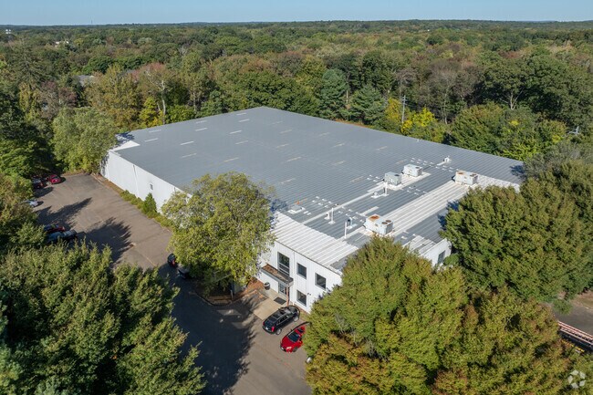
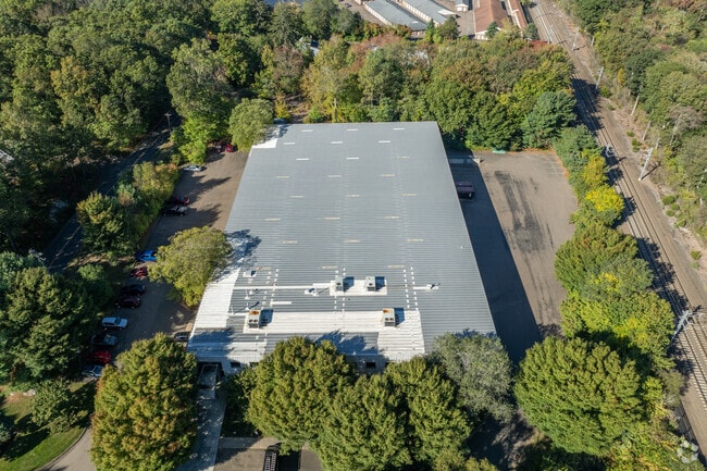
98 Fort Path Rd
Commercialbuilding
South Central Ct
LI
Connecticut
B and X Area of moderate flood hazard, usually the area between the limits of the 100-year and 500-year floods.
4.96 AC
2025
Guilford
2025
Westchester/So Connecticut
194102
New Haven, CT
40,000 SF
MADI-000037-000000-000005
NEARBY LISTINGS FOR SALE OR LEASE
-
-
View all Madison listings for sale on LoopNet.com
DEMOGRAPHICS near 98 Fort Path Rd
1 mile
3 mile
5 mile
2025 Total Population
2,959
15,849
37,431
2030 Population
3,080
16,340
38,302
Pop Growth 2025-2030
+ 4.09%
+ 3.10%
+ 2.33%
Average Age
49
47
46
2025 Total Households
1,291
6,427
15,211
HH Growth 2025-2030
+ 4.11%
+ 3.19%
+ 2.41%
Median Household Inc
$116,950
$132,362
$130,171
Avg Household Size
2.20
2.40
2.40
2025 Avg HH Vehicles
2.00
2.00
2.00
Median Home Value
$674,453
$636,571
$555,435
Median Year Built
1966
1971
1972
Nearby Places
Map Layers
Map Styles
 Street
 Aerial
Layers
 Traffic
 Biking
Places
Listings with unknown addresses are not visible on the map
- Restaurants
- Banks
- Shops
- Fitness
- Groceries
PUBLIC TRANSPORTATION
COMMUTER RAIL
Madison (Shore Line East - Shore Line East)
Drive
Walk
Distance
Madison (Shore Line East - Shore Line East)
5 min
1.1 mi
Drive
Walk
Distance
11 min
5.0 mi
AIRPORT
Tweed/New Haven
Drive
Walk
Distance
Tweed/New Haven
29 min
16.8 mi
Freight Ports
Port of New Haven
Drive
Walk
Distance
Port of New Haven
26 min
16.5 mi
Nearby Properties
Address
Land Use
TOTAL SIZE
Lot Size
Zoning
Address
Land Use
TOTAL SIZE
Lot Size
Zoning
158,618 SF
72.20 AC
RU-2
Address
Land Use
TOTAL SIZE
Lot Size
Zoning
51,202 SF
19 AC
R-3
Address
Land Use
TOTAL SIZE
Lot Size
Zoning
6,026 SF
45 AC
R-2
Address
Land Use
TOTAL SIZE
Lot Size
Zoning
49,294 SF
7.19 AC
C
Address
Land Use
TOTAL SIZE
Lot Size
Zoning
22,590 SF
54.72 AC
RU-2
Address
Land Use
TOTAL SIZE
Lot Size
Zoning
5,995 SF
26.51 AC
R-3
Address
Land Use
TOTAL SIZE
Lot Size
Zoning
45,025 SF
0.93 AC
R-5
Address
Land Use
TOTAL SIZE
Lot Size
Zoning
12,945 SF
15.20 AC
R-2
Address
Land Use
TOTAL SIZE
Lot Size
Zoning
60,070 SF
5.89 AC
DC
Address
Land Use
TOTAL SIZE
Lot Size
Zoning
37,619 SF
37.98 AC
RU-2
Address
Land Use
TOTAL SIZE
Lot Size
Zoning
37,379 SF
1.43 AC
D
Address
Land Use
TOTAL SIZE
Lot Size
Zoning
17,317 SF
5 AC
RU-2
Address
Land Use
TOTAL SIZE
Lot Size
Zoning
7,527 SF
71.77 AC
R-1
Address
Land Use
TOTAL SIZE
Lot Size
Zoning
6,535 SF
12.68 AC
R-2
Address
Land Use
TOTAL SIZE
Lot Size
Zoning
3,996 SF
5.43 AC
R-2
Address
Land Use
TOTAL SIZE
Lot Size
Zoning
58,260 SF
8.59 AC
I
Address
Land Use
TOTAL SIZE
Lot Size
Zoning
3,094 SF
16 AC
BMU
Address
Land Use
TOTAL SIZE
Lot Size
Zoning
36,623 SF
5.13 AC
R-2
Address
Land Use
TOTAL SIZE
Lot Size
Zoning
56,906 SF
16.62 AC
HCFD
Address
Land Use
TOTAL SIZE
Lot Size
Zoning
22,458 SF
6.44 AC
I
Address
Land Use
TOTAL SIZE
Lot Size
Zoning
17,136 SF
4.38 AC
PRB3
Address
Land Use
TOTAL SIZE
Lot Size
Zoning
6.41 AC
I
Address
Land Use
TOTAL SIZE
Lot Size
Zoning
5,074 SF
1.30 AC
D
Address
Land Use
TOTAL SIZE
Lot Size
Zoning
3.87 AC
PRB3
Address
Land Use
TOTAL SIZE
Lot Size
Zoning
27,095 SF
8.62 AC
R-2
Address
Land Use
TOTAL SIZE
Lot Size
Zoning
63,045 SF
9.04 AC
I
Address
Land Use
TOTAL SIZE
Lot Size
Zoning
8,138 SF
3.80 AC
R-2
Address
Land Use
TOTAL SIZE
Lot Size
Zoning
1,920 SF
1.85 AC
D
Address
Land Use
TOTAL SIZE
Lot Size
Zoning
1,260 SF
16.58 AC
R-3
Address
Land Use
TOTAL SIZE
Lot Size
Zoning
183 AC
RU-1
The World's #1 Commercial Real Estate Marketplace
Connect with us
© 2026 CoStar Group
The information above has been obtained from sources believed reliable. While we do not doubt its accuracy we have not verified it and make no guarantee, warranty or representation about it. It is your responsibility to independently confirm its accuracy and completeness. Any projections, opinions, assumptions, or estimates used are for example only and do not represent the current or future performance of the property. The value of this transaction to you depends on tax and other factors which should be evaluated by your tax, financial, and legal advisors. You and your advisors should conduct a careful, independent investigation of the property to determine to your satisfaction the suitability of the property for your needs.