Property Record
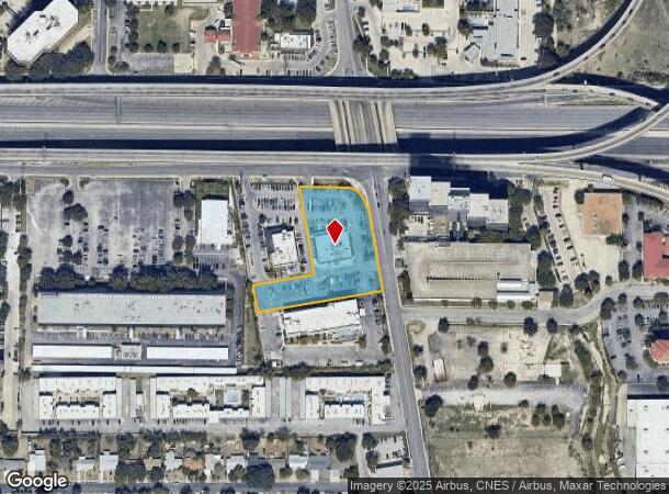
98 Ne Loop 410, San Antonio, TX 78216

NEARBY LISTINGS FOR SALE OR LEASE
Property Detail
98 Ne Loop 410
San Antonio-New Braunfels, TX
Ncb 12025 Blazon 410 Subd
12025-000-0340
NCB 12025 BLK LOT 34 1.952 AC (BLAZON 410 SUBD) 2023 RMS PERSPLIT PER DEED 20220268773 PER CR #58004. 2014-PASS PER PLAT 9654/197-199 EXE 05-10-13, PER EST ESTMNTS AND BUILDING SET-BACK.JPR/GIS/05-21-13
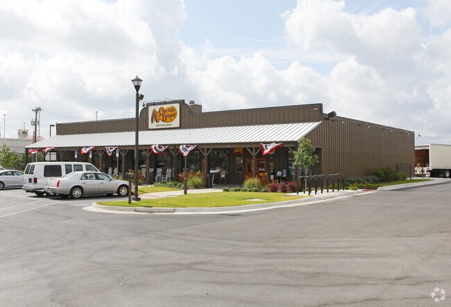
Restaurantbuilding
Bexar
X
Texas
48029C0263H
34
2024
1.95 AC
2025
North Central
190902
San Antonio
9,010 SF
DEMOGRAPHICS near 98 Ne Loop 410
1 Mile
3 Mile
5 Mile
2024 Total Population
9,076
95,984
305,016
2029 Population
9,679
102,325
324,581
Pop Growth 2024-2029
+ 6.64%
+ 6.61%
+ 6.41%
Average Age
37
39
39
2024 Total Households
3,629
41,066
130,279
HH Growth 2024-2029
+ 6.92%
+ 6.90%
+ 6.66%
Median Household Inc
$45,794
$56,763
$55,933
Avg Household Size
2.30
2.30
2.20
2024 Avg HH Vehicles
1.00
2.00
2.00
Median Home Value
$181,355
$279,034
$262,463
Median Year Built
1962
1970
1975
Nearby Places
Map Layers
Map Styles
 Street
 Aerial
- Restaurants
- Banks
- Shops
- Fitness
- Groceries
PUBLIC TRANSPORTATION
COMMUTER RAIL
San Antonio Amtrak Station (Sunset Limited - Amtrak, Texas Eagle - Amtrak)
DRIVE
WALK
Distance
San Antonio Amtrak Station (Sunset Limited - Amtrak, Texas Eagle - Amtrak)
11 min
7.8 mi
AIRPORT
San Antonio International
DRIVE
WALK
Distance
San Antonio International
2 min
0.9 mi
Freight Ports
Calhoun Port
DRIVE
WALK
Distance
Calhoun Port
186 min
153.7 mi
Nearby Properties
Address
Land Use
TOTAL SIZE
Lot Size
Zoning
Address
Land Use
TOTAL SIZE
Lot Size
Zoning
557,078 SF
10.73 AC
Address
Land Use
TOTAL SIZE
Lot Size
Zoning
632,091 SF
27.82 AC
Address
Land Use
TOTAL SIZE
Lot Size
Zoning
338,255 SF
29.62 AC
Address
Land Use
TOTAL SIZE
Lot Size
Zoning
324,360 SF
15.05 AC
Address
Land Use
TOTAL SIZE
Lot Size
Zoning
246,000 SF
22.54 AC
Address
Land Use
TOTAL SIZE
Lot Size
Zoning
46,451 SF
7.03 AC
Address
Land Use
TOTAL SIZE
Lot Size
Zoning
641,471 SF
41.71 AC
Address
Land Use
TOTAL SIZE
Lot Size
Zoning
317,537 SF
25.06 AC
Address
Land Use
TOTAL SIZE
Lot Size
Zoning
56,042 SF
14.60 AC
Address
Land Use
TOTAL SIZE
Lot Size
Zoning
262,515 SF
6.38 AC
Address
Land Use
TOTAL SIZE
Lot Size
Zoning
506,058 SF
25.23 AC
Address
Land Use
TOTAL SIZE
Lot Size
Zoning
250,990 SF
4.89 AC
Address
Land Use
TOTAL SIZE
Lot Size
Zoning
23,738 SF
4.84 AC
Address
Land Use
TOTAL SIZE
Lot Size
Zoning
152,676 SF
13.74 AC
Address
Land Use
TOTAL SIZE
Lot Size
Zoning
33,045 SF
23.63 AC
Address
Land Use
TOTAL SIZE
Lot Size
Zoning
314,264 SF
4.27 AC
Address
Land Use
TOTAL SIZE
Lot Size
Zoning
219,400 SF
6.16 AC
Address
Land Use
TOTAL SIZE
Lot Size
Zoning
360,836 SF
16.87 AC
Address
Land Use
TOTAL SIZE
Lot Size
Zoning
307,193 SF
7.18 AC
Address
Land Use
TOTAL SIZE
Lot Size
Zoning
245,160 SF
15.10 AC
Address
Land Use
TOTAL SIZE
Lot Size
Zoning
392,678 SF
21.04 AC
Address
Land Use
TOTAL SIZE
Lot Size
Zoning
248,547 SF
3.30 AC
Address
Land Use
TOTAL SIZE
Lot Size
Zoning
74,510 SF
6.58 AC
Address
Land Use
TOTAL SIZE
Lot Size
Zoning
272,273 SF
13.62 AC
Address
Land Use
TOTAL SIZE
Lot Size
Zoning
248,413 SF
3.23 AC
Address
Land Use
TOTAL SIZE
Lot Size
Zoning
192,175 SF
5.08 AC
Address
Land Use
TOTAL SIZE
Lot Size
Zoning
308,299 SF
14.55 AC
Address
Land Use
TOTAL SIZE
Lot Size
Zoning
58,461 SF
3.60 AC
Address
Land Use
TOTAL SIZE
Lot Size
Zoning
207,297 SF
4.32 AC
Address
Land Use
TOTAL SIZE
Lot Size
Zoning
220,394 SF
10 AC
The World's #1 Commercial Real Estate Marketplace
Connect with us
© 2025 CoStar Group
The information above has been obtained from sources believed reliable. While we do not doubt its accuracy we have not verified it and make no guarantee, warranty or representation about it. It is your responsibility to independently confirm its accuracy and completeness. Any projections, opinions, assumptions, or estimates used are for example only and do not represent the current or future performance of the property. The value of this transaction to you depends on tax and other factors which should be evaluated by your tax, financial, and legal advisors. You and your advisors should conduct a careful, independent investigation of the property to determine to your satisfaction the suitability of the property for your needs.