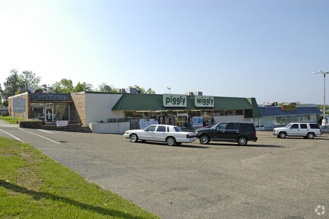
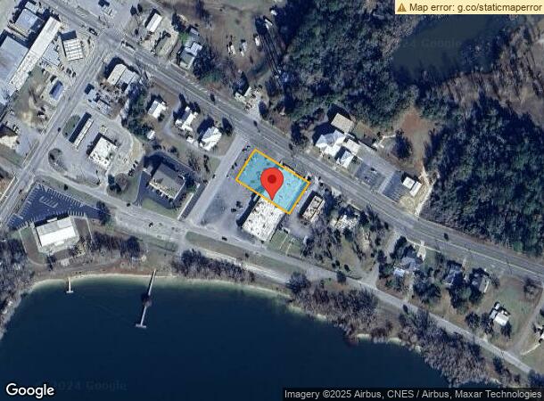
Property Record
980 2Nd St, Florala, AL 36442
NEARBY LISTINGS FOR SALE OR LEASE
-
-
View all Florala listings for sale on LoopNet.com
Property Detail
980 2Nd St
29-07-35-3-301-020.001
Hughes Addn-Florala
Supermarket
DB/PG>2012/554 1/10/12 LT 8-12 BLK 7 HUGHES ADD SEC 35 T1N R17E PB 1 PG 1
X
Covington
01039C0575C
Alabama
2025
8-12
2025
0.90 AC
963000
Alabama South Area
13,462 SF
Other Market Areas
DEMOGRAPHICS near 980 2Nd St
1 mile
3 mile
5 mile
2024 Total Population
1,742
2,973
3,580
2029 Population
1,767
3,145
3,825
Pop Growth 2024-2029
+ 1.44%
+ 5.79%
+ 6.84%
Average Age
44
43
43
2024 Total Households
751
1,233
1,470
HH Growth 2024-2029
+ 1.33%
+ 5.43%
+ 6.46%
Median Household Inc
$30,682
$40,540
$40,800
Avg Household Size
2.20
2.30
2.30
2024 Avg HH Vehicles
1.00
2.00
2.00
Median Home Value
$96,052
$104,694
$102,473
Median Year Built
1975
1979
1980
Nearby Places
Map Layers
Map Styles
 Street
 Aerial
Transit
 Traffic
 Biking
Places
Listings with unknown addresses are not visible on the map
- Restaurants
- Banks
- Shops
- Fitness
- Groceries
Nearby Properties
Address
Land Use
TOTAL SIZE
Lot Size
Zoning
Address
Land Use
TOTAL SIZE
Lot Size
Zoning
49,436 SF
5.90 AC
Address
Land Use
TOTAL SIZE
Lot Size
Zoning
9,365 SF
1.58 AC
MUNI
Address
Land Use
TOTAL SIZE
Lot Size
Zoning
36,268 SF
28.50 AC
Address
Land Use
TOTAL SIZE
Lot Size
Zoning
5,838 SF
35 AC
RR
Address
Land Use
TOTAL SIZE
Lot Size
Zoning
5,184 SF
137.21 AC
Address
Land Use
TOTAL SIZE
Lot Size
Zoning
10,999 SF
1.83 AC
Address
Land Use
TOTAL SIZE
Lot Size
Zoning
10,294 SF
14.79 AC
UR
Address
Land Use
TOTAL SIZE
Lot Size
Zoning
23,268 SF
85.19 AC
MUNI
Address
Land Use
TOTAL SIZE
Lot Size
Zoning
10,836 SF
4.96 AC
LKJACK
Address
Land Use
TOTAL SIZE
Lot Size
Zoning
5,050 SF
0.43 AC
LKJACK
Address
Land Use
TOTAL SIZE
Lot Size
Zoning
7,312 SF
20.52 AC
GA
Address
Land Use
TOTAL SIZE
Lot Size
Zoning
10,802 SF
3.78 AC
LKJACK
Address
Land Use
TOTAL SIZE
Lot Size
Zoning
16,748 SF
27.33 AC
Address
Land Use
TOTAL SIZE
Lot Size
Zoning
10,653 SF
6.93 AC
Address
Land Use
TOTAL SIZE
Lot Size
Zoning
5,228 SF
9.94 AC
Address
Land Use
TOTAL SIZE
Lot Size
Zoning
5,444 SF
42 AC
RR
Address
Land Use
TOTAL SIZE
Lot Size
Zoning
3,592 SF
12.12 AC
Address
Land Use
TOTAL SIZE
Lot Size
Zoning
4,032 SF
2.02 AC
Address
Land Use
TOTAL SIZE
Lot Size
Zoning
3,654 SF
2.23 AC
MUNI
Address
Land Use
TOTAL SIZE
Lot Size
Zoning
7,116 SF
75 AC
Address
Land Use
TOTAL SIZE
Lot Size
Zoning
3,491 SF
0.99 AC
MUNI
Address
Land Use
TOTAL SIZE
Lot Size
Zoning
4,477 SF
0.77 AC
LKJACK
Address
Land Use
TOTAL SIZE
Lot Size
Zoning
4,564 SF
2.51 AC
Address
Land Use
TOTAL SIZE
Lot Size
Zoning
1,028 SF
8 AC
Address
Land Use
TOTAL SIZE
Lot Size
Zoning
2,727 SF
29 AC
Address
Land Use
TOTAL SIZE
Lot Size
Zoning
1,229 SF
4.01 AC
LKJACK
Address
Land Use
TOTAL SIZE
Lot Size
Zoning
1,500 SF
31 AC
Address
Land Use
TOTAL SIZE
Lot Size
Zoning
2,286 SF
28.16 AC
UR
Address
Land Use
TOTAL SIZE
Lot Size
Zoning
5,067 SF
0.40 AC
Address
Land Use
TOTAL SIZE
Lot Size
Zoning
4,225 SF
27.73 AC
The World's #1 Commercial Real Estate Marketplace
Connect with us
© 2026 CoStar Group
The information above has been obtained from sources believed reliable. While we do not doubt its accuracy we have not verified it and make no guarantee, warranty or representation about it. It is your responsibility to independently confirm its accuracy and completeness. Any projections, opinions, assumptions, or estimates used are for example only and do not represent the current or future performance of the property. The value of this transaction to you depends on tax and other factors which should be evaluated by your tax, financial, and legal advisors. You and your advisors should conduct a careful, independent investigation of the property to determine to your satisfaction the suitability of the property for your needs.