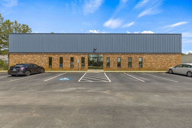
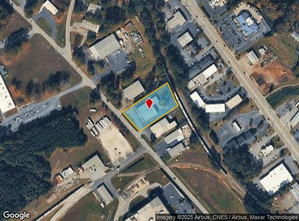
Property Record
980 N Maple St, Simpsonville, SC 29681

NEARBY LISTINGS FOR SALE OR LEASE
Property Detail
980 N Maple St
Greenville-Anderson-Mauldin, SC
Mckee Joseph
0303.00-01-004.15
20
Warehouse
Greenville
X
South Carolina
45045C0419E
004.15
2024
1.30 AC
2024
I-385/Simpsonville
003008
Greenville/Spartanburg
DEMOGRAPHICS near 980 N Maple St
1 Mile
3 Mile
5 Mile
2024 Total Population
4,111
49,790
131,292
2029 Population
4,490
54,812
144,897
Pop Growth 2024-2029
+ 9.22%
+ 10.09%
+ 10.36%
Average Age
41
40
40
2024 Total Households
1,650
19,308
50,686
HH Growth 2024-2029
+ 9.33%
+ 10.16%
+ 10.46%
Median Household Inc
$74,181
$84,920
$87,350
Avg Household Size
2.50
2.50
2.60
2024 Avg HH Vehicles
2.00
2.00
2.00
Median Home Value
$247,680
$242,882
$255,740
Median Year Built
1996
1995
1999
Nearby Places
Map Layers
Map Styles
 Street
 Aerial
- Restaurants
- Banks
- Shops
- Fitness
- Groceries
PUBLIC TRANSPORTATION
AIRPORT
Greenville Spartanburg International
DRIVE
WALK
Distance
Greenville Spartanburg International
20 min
13.7 mi
SALE & LEASE HISTORY
LISTING DATE
SALE/LEASE

Apr 15, 2025
For Lease
Apr 15, 2025
For Sale
Nearby Properties
Address
Land Use
TOTAL SIZE
Lot Size
Zoning
Address
Land Use
TOTAL SIZE
Lot Size
Zoning
10.20 AC
R12
Address
Land Use
TOTAL SIZE
Lot Size
Zoning
23.23 AC
Address
Land Use
TOTAL SIZE
Lot Size
Zoning
11.91 AC
RM20
Address
Land Use
TOTAL SIZE
Lot Size
Zoning
12.31 AC
Address
Land Use
TOTAL SIZE
Lot Size
Zoning
17.59 AC
Address
Land Use
TOTAL SIZE
Lot Size
Zoning
29.21 AC
I1
Address
Land Use
TOTAL SIZE
Lot Size
Zoning
Address
Land Use
TOTAL SIZE
Lot Size
Zoning
10.78 AC
I1
Address
Land Use
TOTAL SIZE
Lot Size
Zoning
4.59 AC
BI
Address
Land Use
TOTAL SIZE
Lot Size
Zoning
195.23 AC
RRROW
Address
Land Use
TOTAL SIZE
Lot Size
Zoning
9.46 AC
I1
Address
Land Use
TOTAL SIZE
Lot Size
Zoning
12.43 AC
RS
Address
Land Use
TOTAL SIZE
Lot Size
Zoning
5.30 AC
BI
Address
Land Use
TOTAL SIZE
Lot Size
Zoning
76.20 AC
R20
Address
Land Use
TOTAL SIZE
Lot Size
Zoning
7.03 AC
I1
Address
Land Use
TOTAL SIZE
Lot Size
Zoning
12.31 AC
I1
Address
Land Use
TOTAL SIZE
Lot Size
Zoning
50.76 AC
PDC
Address
Land Use
TOTAL SIZE
Lot Size
Zoning
96.14 AC
NZ
Address
Land Use
TOTAL SIZE
Lot Size
Zoning
26.30 AC
ROI
Address
Land Use
TOTAL SIZE
Lot Size
Zoning
10.50 AC
RRROW
Address
Land Use
TOTAL SIZE
Lot Size
Zoning
Address
Land Use
TOTAL SIZE
Lot Size
Zoning
12.11 AC
BG
Address
Land Use
TOTAL SIZE
Lot Size
Zoning
51.30 AC
RS
Address
Land Use
TOTAL SIZE
Lot Size
Zoning
8.23 AC
S1
Address
Land Use
TOTAL SIZE
Lot Size
Zoning
17.65 AC
ID
Address
Land Use
TOTAL SIZE
Lot Size
Zoning
65.40 AC
RS
Address
Land Use
TOTAL SIZE
Lot Size
Zoning
17.02 AC
BG
Address
Land Use
TOTAL SIZE
Lot Size
Zoning
3.20 AC
I1
Address
Land Use
TOTAL SIZE
Lot Size
Zoning
31.90 AC
I1
The World's #1 Commercial Real Estate Marketplace
Connect with us
© 2025 CoStar Group
The information above has been obtained from sources believed reliable. While we do not doubt its accuracy we have not verified it and make no guarantee, warranty or representation about it. It is your responsibility to independently confirm its accuracy and completeness. Any projections, opinions, assumptions, or estimates used are for example only and do not represent the current or future performance of the property. The value of this transaction to you depends on tax and other factors which should be evaluated by your tax, financial, and legal advisors. You and your advisors should conduct a careful, independent investigation of the property to determine to your satisfaction the suitability of the property for your needs.