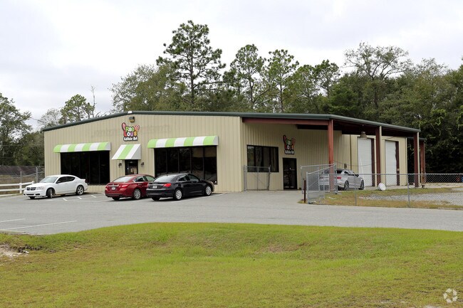
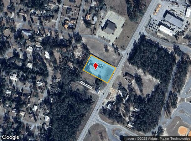
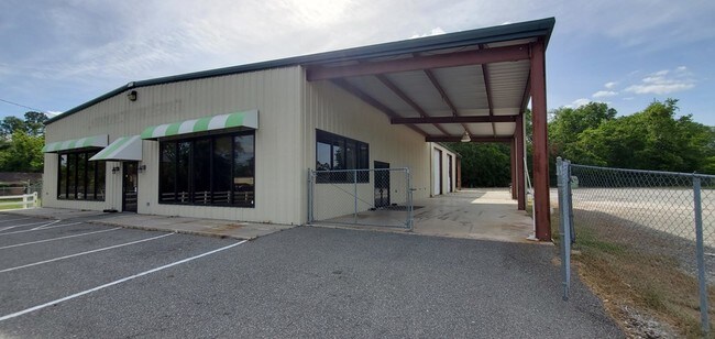
Property Record
980 S Us Highway 301, Jesup, GA 31546
NEARBY LISTINGS FOR SALE OR LEASE
Property Detail
980 S Us Highway 301
100-7
Ff - 150
Commercialnec
PLAT4-38 PB 15-73
X
Wayne
13305C0234C
Georgia
2024
1.24 AC
2025
Georgia South Area
970500
Other Market Areas
6,000 SF
Jesup, GA
DEMOGRAPHICS near 980 S Us Highway 301
1 Mile
3 Mile
5 Mile
2024 Total Population
2,994
10,388
15,222
2029 Population
3,118
10,846
15,893
Pop Growth 2024-2029
+ 4.14%
+ 4.41%
+ 4.41%
Average Age
40
41
41
2024 Total Households
904
3,575
5,407
HH Growth 2024-2029
+ 4.20%
+ 4.48%
+ 4.51%
Median Household Inc
$61,326
$50,491
$44,608
Avg Household Size
2.50
2.40
2.40
2024 Avg HH Vehicles
2.00
2.00
2.00
Median Home Value
$135,588
$138,497
$135,218
Median Year Built
1968
1973
1977
Nearby Places
Map Layers
Map Styles
 Street
 Aerial
- Restaurants
- Banks
- Shops
- Fitness
- Groceries
PUBLIC TRANSPORTATION
COMMUTER RAIL
Jesup Amtrak Station (Silver Meteor - Amtrak)
DRIVE
WALK
Distance
Jesup Amtrak Station (Silver Meteor - Amtrak)
3 min
1.8 mi
Freight Ports
Georgia Ports - Brunswick
DRIVE
WALK
Distance
Georgia Ports - Brunswick
62 min
44.6 mi
SALE & LEASE HISTORY
LISTING DATE
SALE/LEASE

Nov 15, 2018
For Sale
Jun 14, 2019
For Sale
Nearby Properties
Address
Land Use
TOTAL SIZE
Lot Size
Zoning
Address
Land Use
TOTAL SIZE
Lot Size
Zoning
198,150 SF
376 AC
Address
Land Use
TOTAL SIZE
Lot Size
Zoning
196,000 SF
56.48 AC
Address
Land Use
TOTAL SIZE
Lot Size
Zoning
128,875 SF
9.59 AC
Address
Land Use
TOTAL SIZE
Lot Size
Zoning
131,475 SF
19.09 AC
Address
Land Use
TOTAL SIZE
Lot Size
Zoning
147,829 SF
17.80 AC
Address
Land Use
TOTAL SIZE
Lot Size
Zoning
60,000 SF
23.69 AC
Address
Land Use
TOTAL SIZE
Lot Size
Zoning
33,161 SF
10 AC
Address
Land Use
TOTAL SIZE
Lot Size
Zoning
3,696 SF
10.33 AC
Address
Land Use
TOTAL SIZE
Lot Size
Zoning
41,400 SF
10 AC
Address
Land Use
TOTAL SIZE
Lot Size
Zoning
9,690 SF
2.72 AC
Address
Land Use
TOTAL SIZE
Lot Size
Zoning
56,413 SF
2.74 AC
Address
Land Use
TOTAL SIZE
Lot Size
Zoning
26,140 SF
10 AC
Address
Land Use
TOTAL SIZE
Lot Size
Zoning
21,000 SF
8.53 AC
Address
Land Use
TOTAL SIZE
Lot Size
Zoning
Address
Land Use
TOTAL SIZE
Lot Size
Zoning
58,162 SF
4.05 AC
Address
Land Use
TOTAL SIZE
Lot Size
Zoning
13,438 SF
1.46 AC
Address
Land Use
TOTAL SIZE
Lot Size
Zoning
21,275 SF
0.51 AC
Address
Land Use
TOTAL SIZE
Lot Size
Zoning
48,000 SF
17.31 AC
Address
Land Use
TOTAL SIZE
Lot Size
Zoning
10,230 SF
0.84 AC
Address
Land Use
TOTAL SIZE
Lot Size
Zoning
3,900 SF
148.81 AC
Address
Land Use
TOTAL SIZE
Lot Size
Zoning
12,402 SF
2.02 AC
Address
Land Use
TOTAL SIZE
Lot Size
Zoning
43,882 SF
0.92 AC
Address
Land Use
TOTAL SIZE
Lot Size
Zoning
32,280 SF
2.40 AC
Address
Land Use
TOTAL SIZE
Lot Size
Zoning
45,000 SF
47.86 AC
Address
Land Use
TOTAL SIZE
Lot Size
Zoning
10,344 SF
10 AC
Address
Land Use
TOTAL SIZE
Lot Size
Zoning
19,050 SF
4.42 AC
Address
Land Use
TOTAL SIZE
Lot Size
Zoning
10,712 SF
1.28 AC
Address
Land Use
TOTAL SIZE
Lot Size
Zoning
7,744 SF
8.16 AC
Address
Land Use
TOTAL SIZE
Lot Size
Zoning
92,414 SF
14.27 AC
Address
Land Use
TOTAL SIZE
Lot Size
Zoning
14,544 SF
5.74 AC
The World's #1 Commercial Real Estate Marketplace
Connect with us
© 2026 CoStar Group
The information above has been obtained from sources believed reliable. While we do not doubt its accuracy we have not verified it and make no guarantee, warranty or representation about it. It is your responsibility to independently confirm its accuracy and completeness. Any projections, opinions, assumptions, or estimates used are for example only and do not represent the current or future performance of the property. The value of this transaction to you depends on tax and other factors which should be evaluated by your tax, financial, and legal advisors. You and your advisors should conduct a careful, independent investigation of the property to determine to your satisfaction the suitability of the property for your needs.