Property Record
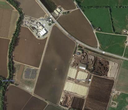
980 State Highway 25, Gilroy, CA 95020

Property Detail
980 State Highway 25
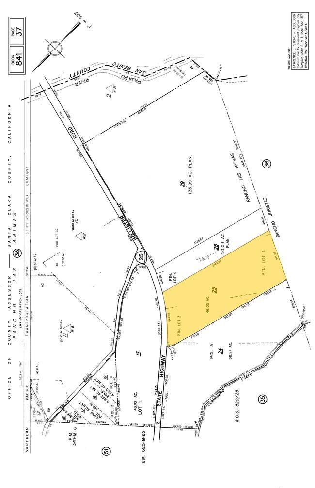
841-37-025
SANTA CLARA
Agriculturalland
California
A-40A
2-3
A Areas with a 1% annual chance of flooding and a 26% chance of flooding over the life of a 30-year mortgage.
46.05 AC
2024
Outlying Santa Clara Cnty
2025
South Bay/San Jose
512602
San Jose-Sunnyvale-Santa Clara, CA
NEARBY LISTINGS FOR SALE OR LEASE
-
-
-
-
-
No Photo
-
View all Gilroy listings for sale on LoopNet.com
DEMOGRAPHICS near 980 State Highway 25
1 mile
3 mile
5 mile
2025 Total Population
32
1,073
25,385
2030 Population
32
1,052
26,008
Pop Growth 2025-2030
0.00%
(1.96%)
+ 2.45%
Average Age
39
39
37
2025 Total Households
10
320
7,122
HH Growth 2025-2030
(10.00%)
(1.88%)
+ 2.39%
Median Household Inc
$158,333
$141,987
$119,796
Avg Household Size
3.60
3.20
3.40
2025 Avg HH Vehicles
3.00
3.00
2.00
Median Home Value
$99,999
$622,093
$887,013
Median Year Built
1969
1971
1983
Nearby Places
Map Layers
Map Styles
 Street
 Aerial
Layers
 Traffic
 Biking
Places
Listings with unknown addresses are not visible on the map
- Restaurants
- Banks
- Shops
- Fitness
- Groceries
PUBLIC TRANSPORTATION
COMMUTER RAIL
Gilroy Caltrain Station Southbound (South Santa Clara County Connector - Caltrain (Caltrain))
Drive
Walk
Distance
Gilroy Caltrain Station Southbound (South Santa Clara County Connector - Caltrain (Caltrain))
8 min
5.0 mi
Freight Ports
Port of Redwood City
Drive
Walk
Distance
Port of Redwood City
70 min
58.2 mi
SALE & LEASE HISTORY
LISTING DATE
SALE/LEASE

Sep 24, 2016
For Sale
Nearby Properties
Address
Land Use
TOTAL SIZE
Lot Size
Zoning
Address
Land Use
TOTAL SIZE
Lot Size
Zoning
189,303 SF
28.73 AC
CM
Address
Land Use
TOTAL SIZE
Lot Size
Zoning
55.03 AC
AW
Address
Land Use
TOTAL SIZE
Lot Size
Zoning
56,020 SF
2.61 AC
M2
Address
Land Use
TOTAL SIZE
Lot Size
Zoning
120,665 SF
6.25 AC
M2
Address
Land Use
TOTAL SIZE
Lot Size
Zoning
62,400 SF
2.57 AC
M2
Address
Land Use
TOTAL SIZE
Lot Size
Zoning
13,844 SF
5.85 AC
CT
Address
Land Use
TOTAL SIZE
Lot Size
Zoning
8.68 AC
M1
Address
Land Use
TOTAL SIZE
Lot Size
Zoning
31,613 SF
2.11 AC
M2
Address
Land Use
TOTAL SIZE
Lot Size
Zoning
61,240 SF
12.34 AC
A-20A
Address
Land Use
TOTAL SIZE
Lot Size
Zoning
20.03 AC
CM
Address
Land Use
TOTAL SIZE
Lot Size
Zoning
19,427 SF
68.57 AC
A-40A
Address
Land Use
TOTAL SIZE
Lot Size
Zoning
14.05 AC
A-40A
Address
Land Use
TOTAL SIZE
Lot Size
Zoning
42,570 SF
8.21 AC
IPUD
Address
Land Use
TOTAL SIZE
Lot Size
Zoning
26,071 SF
1.44 AC
M2
Address
Land Use
TOTAL SIZE
Lot Size
Zoning
175.36 AC
GI
Address
Land Use
TOTAL SIZE
Lot Size
Zoning
1,275.14 AC
AR
Address
Land Use
TOTAL SIZE
Lot Size
Zoning
9.97 AC
A-40A
Address
Land Use
TOTAL SIZE
Lot Size
Zoning
36,000 SF
4.81 AC
M1
Address
Land Use
TOTAL SIZE
Lot Size
Zoning
19.70 AC
Address
Land Use
TOTAL SIZE
Lot Size
Zoning
24,000 SF
6.11 AC
M2
Address
Land Use
TOTAL SIZE
Lot Size
Zoning
2,016 SF
1.06 AC
HC
Address
Land Use
TOTAL SIZE
Lot Size
Zoning
20,000 SF
136.99 AC
A-40A
Address
Land Use
TOTAL SIZE
Lot Size
Zoning
10,152 SF
0.52 AC
M2
Address
Land Use
TOTAL SIZE
Lot Size
Zoning
6,630 SF
0.49 AC
A140
Address
Land Use
TOTAL SIZE
Lot Size
Zoning
2,622 SF
1.09 AC
CM
Address
Land Use
TOTAL SIZE
Lot Size
Zoning
3,090 SF
0.70 AC
IPUD
Address
Land Use
TOTAL SIZE
Lot Size
Zoning
25,665 SF
1.19 AC
M2
Address
Land Use
TOTAL SIZE
Lot Size
Zoning
53.70 AC
AW
Address
Land Use
TOTAL SIZE
Lot Size
Zoning
18.31 AC
A
The World's #1 Commercial Real Estate Marketplace
Connect with us
© 2026 CoStar Group
The information above has been obtained from sources believed reliable. While we do not doubt its accuracy we have not verified it and make no guarantee, warranty or representation about it. It is your responsibility to independently confirm its accuracy and completeness. Any projections, opinions, assumptions, or estimates used are for example only and do not represent the current or future performance of the property. The value of this transaction to you depends on tax and other factors which should be evaluated by your tax, financial, and legal advisors. You and your advisors should conduct a careful, independent investigation of the property to determine to your satisfaction the suitability of the property for your needs.